
Lawrence County, Illinois facts for kids
Quick facts for kids
Lawrence County
|
|
|---|---|

Lawrence County Courthouse in Lawrenceville
|
|

Location within the U.S. state of Illinois
|
|
 Illinois's location within the U.S. |
|
| Country | |
| State | |
| Founded | 1821 |
| Named for | James Lawrence |
| Seat | Lawrenceville |
| Largest city | Lawrenceville |
| Area | |
| • Total | 374 sq mi (970 km2) |
| • Land | 372 sq mi (960 km2) |
| • Water | 2.0 sq mi (5 km2) |
| Population
(2020)
|
|
| • Total | 15,280 |
| • Density | 40.86/sq mi (15.774/km2) |
| Time zone | UTC−6 (Central) |
| • Summer (DST) | UTC−5 (CDT) |
| Congressional district | 15th |
Lawrence County is the easternmost county in the U.S. state of Illinois. At the 2020 census, the population was 15,280. Its county seat is Lawrenceville.
Contents
History
Lawrence County was formed in 1821 out of Crawford and Edwards counties. It was named for Captain James Lawrence, who was killed in action during the War of 1812 while commanding the frigate USS Chesapeake. Mortally wounded, he gave his men the famous last order, "Don't give up the ship."
-

Lawrence County from its creation in 1821 to 1824
-
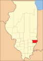
Lawrence County between 1824 and 1841
-
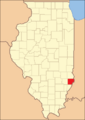
Lawrence County in 1841, when the creation of Richland County reduced Lawrence to its current size


Geography
According to the U.S. Census Bureau, the county has a total area of 374 square miles (970 km2), of which 372 square miles (960 km2) is land and 2.0 square miles (5.2 km2) (0.5%) is water.
Climate and weather
| Weather chart for Lawrenceville, Illinois | |||||||||||||||||||||||||||||||||||||||||||||||
|---|---|---|---|---|---|---|---|---|---|---|---|---|---|---|---|---|---|---|---|---|---|---|---|---|---|---|---|---|---|---|---|---|---|---|---|---|---|---|---|---|---|---|---|---|---|---|---|
| J | F | M | A | M | J | J | A | S | O | N | D | ||||||||||||||||||||||||||||||||||||
|
2.6
36
18
|
2.5
42
22
|
3.6
53
32
|
4.3
65
42
|
5.1
75
52
|
4.1
84
61
|
4.7
88
65
|
3.7
86
63
|
3.2
80
54
|
3.2
68
42
|
4.3
54
33
|
3.2
42
23
|
||||||||||||||||||||||||||||||||||||
| temperatures in °F precipitation totals in inches source: The Weather Channel |
|||||||||||||||||||||||||||||||||||||||||||||||
|
Metric conversion
|
|||||||||||||||||||||||||||||||||||||||||||||||
In recent years, average temperatures in the county seat of Lawrenceville have ranged from a low of 18 °F (−8 °C) in January to a high of 88 °F (31 °C) in July, although a record low of −26 °F (−32 °C) was recorded in January 1994 and a record high of 104 °F (40 °C) was recorded in June 1988. Average monthly precipitation ranged from 2.51 inches (64 mm) in February to 5.13 inches (130 mm) in May.
Major highways
 U.S. Route 50
 Illinois Route 1
 Illinois Route 33
 Illinois Route 250
Adjacent counties
- Crawford County - north
- Knox County, Indiana - east
- Wabash County - south
- Richland County - west
Demographics
| Historical population | |||
|---|---|---|---|
| Census | Pop. | %± | |
| 1830 | 3,668 | — | |
| 1840 | 7,092 | 93.3% | |
| 1850 | 6,121 | −13.7% | |
| 1860 | 9,214 | 50.5% | |
| 1870 | 12,533 | 36.0% | |
| 1880 | 13,663 | 9.0% | |
| 1890 | 14,693 | 7.5% | |
| 1900 | 16,523 | 12.5% | |
| 1910 | 22,661 | 37.1% | |
| 1920 | 21,380 | −5.7% | |
| 1930 | 21,885 | 2.4% | |
| 1940 | 21,075 | −3.7% | |
| 1950 | 20,539 | −2.5% | |
| 1960 | 18,540 | −9.7% | |
| 1970 | 17,522 | −5.5% | |
| 1980 | 17,807 | 1.6% | |
| 1990 | 15,972 | −10.3% | |
| 2000 | 15,452 | −3.3% | |
| 2010 | 16,833 | 8.9% | |
| 2020 | 15,280 | −9.2% | |
| U.S. Decennial Census 1790-1960 1900-1990 1990-2000 2010-2013 |
|||

As of the 2010 United States Census, there were 16,833 people, 6,130 households, and 4,056 families living in the county. The population density was 45.2 inhabitants per square mile (17.5/km2). There were 6,936 housing units at an average density of 18.6 per square mile (7.2/km2). The racial makeup of the county was 87.3% white, 9.6% black or African American, 0.2% Asian, 0.2% American Indian, 1.7% from other races, and 1.0% from two or more races. Those of Hispanic or Latino origin made up 3.3% of the population. In terms of ancestry, 12.7% were German, 10.4% were American, 9.5% were Irish, and 7.8% were English.
Of the 6,130 households, 28.6% had children under the age of 18 living with them, 50.7% were married couples living together, 10.7% had a female householder with no husband present, 33.8% were non-families, and 30.1% of all households were made up of individuals. The average household size was 2.34 and the average family size was 2.88. The median age was 39.7 years.
The median income for a household in the county was $38,771 and the median income for a family was $45,565. Males had a median income of $40,949 versus $25,991 for females. The per capita income for the county was $19,297. About 14.8% of families and 17.5% of the population were below the poverty line, including 26.9% of those under age 18 and 7.7% of those age 65 or over.
Communities
Cities
Villages
Unincorporated towns
Townships
Nine townships make up Lawrence County. They are:
- Allison
- Bond
- Bridgeport
- Christy
- Denison
- Lawrence
- Lukin
- Petty
- Russell
See also
 In Spanish: Condado de Lawrence (Illinois) para niños
