
LeLoup, Kansas facts for kids
Quick facts for kids
LeLoup, Kansas
|
|
|---|---|

|
|

LeLoup, Kansas
Location in Kansas

LeLoup, Kansas
Location in the United States
|
|
| Country | United States |
| State | Kansas |
| County | Franklin |
| Founded | 1870 |
| Named for | Wolf |
| Elevation | 955 ft (291 m) |
| Time zone | UTC-6 (CST) |
| • Summer (DST) | UTC-5 (CDT) |
| Area code | 785 |
| FIPS code | 20-39300 |
| GNIS ID | 479371 |
LeLoup is an unincorporated community in Franklin County, Kansas, United States. It is located a mile and half north of Interstate 35 on Tennessee Road, 11 miles northeast of Ottawa, 7 miles southwest of Wellsville.
History
LeLoup was founded in 1870 after the Santa Fe Railroad laid tracks through the area. The town was originally named Ferguson after Robert Ferguson, the original owner of the town site. The town was renamed LeLoup after a French traveler got off at Ferguson and mistook a coyote for a wolf and began shouting "le loup". The town then voted to change the name to LeLoup.
LeLoup had a post office from September 1870 until 1954; the name of the post office was changed from Ferguson in 1879.
Geography
LeLoup is located a mile and half north of Interstate 35 on Tennessee Road, 11 miles northeast of Ottawa, 7 miles southwest of Wellsville.
- Fitzgerald, Daniel. Ghost Towns of Kansas 6. 2009.
Images for kids
-
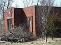
An old school in LeLoup (2008)

