
Leatherhead facts for kids
Quick facts for kids Leatherhead |
|
|---|---|
_(July_2013)_(1).JPG) 2 Bridge Street, Leatherhead |
|

Leatherhead
|
|
| Area | 12.54 km2 (4.84 sq mi) |
| Population | 11,316 (2011 census) or 32,522 as to its Built-up Area which extends to Effingham |
| • Density | 902/km2 (2,340/sq mi) |
| OS grid reference | TQ1656 |
| • London | 17 mi (27 km) north |
| District |
|
| Shire county | |
| Region | |
| Country | England |
| Sovereign state | United Kingdom |
| Post town | Leatherhead |
| Postcode district | KT22 |
| Dialling code | 01372 |
| Police | Surrey |
| Fire | Surrey |
| Ambulance | South East Coast |
| EU Parliament | South East England |
| UK Parliament |
|
Leatherhead is a town in the Mole Valley District of Surrey, England, about 17 mi (27 km) south of Central London. The settlement grew up beside a ford on the River Mole, from which its name is thought to derive. During the late Anglo-Saxon period, Leatherhead was a royal vill and is first mentioned in the will of Alfred the Great in 880 AD. The first bridge may have been constructed in around 1200 and this may have coincided with the expansion of the town and the enlargement of the parish church.
For much of its history, Leatherhead was primarily an agricultural settlement, with a weekly market being held until the mid-Elizabethan era. The construction of turnpike roads in the mid-18th century and the arrival of the railways in the second half of the 19th century attracted newcomers to the town and began to stimulate the local economy. Large-scale manufacturing industries arrived following the end of the First World War and companies with factories in the town included Ronson and Goblin Vacuum Cleaners. Several organisations working with disabled people also opened treatment and training facilities, including The Royal School for the Blind, Queen Elizabeth's Foundation and the Ex-services Welfare Society.
Towards the end of the 20th century, manufacturing in Leatherhead had begun to decline and the town was instead starting to attract service sector employers. The former industrial areas were converted to business parks, which attracted multinational companies, including Esso and Unilever. A controversial redevelopment took place in the town centre in the early 1980s, which included the construction of the Swan Centre. The work, which also included the pedestrianisation of the main shopping area, was widely blamed for a decline in the local retail economy. In 2002, the BBC identified Leatherhead as having one of the worst High Streets in England, but in 2007, the local press described the town centre as "bustling".
Contents
History
Pre-1800
The origins of the town of Leatherhead are Anglo-Saxon. Ashtead lay within the Copthorne hundred by the formation of the Kingdom of England. The Leatherhead Museum has traced the history of the town from its beginnings in about AD 880 when it was known as Leodridan meaning "place where people [can] ride [across the river]" in the Anglo-Saxon (Old English). Later in the Domesday Book of 1086 it was called Leret. Later forms recorded are "Lereda", "Ledreda", "Leddrede" (all second half of 12th century). The early settlement appears to have grown up on the east side of the River Mole, although Hawk's Hill, on the west side of the river, is said to be the site of an old Saxon burial ground.
A view from the University of Sussex has been put forward that the Anglo-Saxon form was distorted from a Celtic form whose Welsh equivalent is Llwyd-rhyd = "grey ford". Within 2 miles (3.2 km) there is evidence of pre-historic and Celtic hillfarming on the North Downs to the east and south - The Druid's Grove, Norbury Park being a possible example of a place of pre-Christian pagan gathering.
To the east of the town is the line of Stane Street, an old Roman road. Most of it is now built over or is used as wooded and hillside footpaths. The road leads from London to Chichester, passing through the strategic Mole Gap.
Elements such as barrows by the A246 provide evidence for a second late Romano-British road that ran from Stane Street in the east close to Ashtead Church crossing the Mole at Leatherhead Bridge some miles to approximately the present road junction very close to Effingham Church. Here it veered more true west and continued in another straight line to Merrow Church crossing the River Wey near Guildford Bridge. The road existed by late Saxon times and all the medieval churches between Leatherhead and Guildford lie within a few yards of this route.
Work on the parish church was started some time in the 11th century. Many parts were added over the years, with a major restoration taking place in the Victorian era.
Leatherhead appears in Domesday Book of 1086 as Leret. It was held by Osbern de Ow (Eu). Its Domesday assets were: 1 church, belonging to Ewell, with 40 acres (160,000 m2). It rendered £1. Pachesham within Leatherhead appears in Domesday Book as Pachesham. It was held by Hugo (Hugh) from the Bishop of Lisieux. Its domesday assets were: 3 virgates. It had part of 2 mills worth 12 shillings, 4 ploughs, 5 acres (20,000 m2) of meadow, woodland worth 3 hogs. It rendered a relatively low £3 10s 0d (£3.50) per year to its feudal system overlords.
A market serving the developing agricultural economy developed at the crossroads and in 1248, Henry III granted to Leatherhead a weekly market and annual fair. The town survived an extensive fire in 1392, after which it was largely rebuilt. In common with many similar medieval towns, Leatherhead had a market house and set of stocks, probably located at the junction of Bridge Street, North Street and High Street.
.jpg)
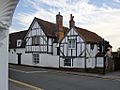
The Running Horse pub dates back to 1403 and is one of the oldest buildings in Leatherhead. It is on the bank of the River Mole, at the southern approach to the town centre. History has it that Elizabeth I once spent a night at the inn when floods made the River Mole impossible to cross.
During the Elizabethan and Stuart periods, the town was associated with several notable people. Edmund Tylney, Master of the Revels, who was in effect the official censor of the time to Queen Elizabeth I, lived in Leatherhead's The Mansion. A Wetherspoons pub in High Street is now named after him. Another notable local noble was Sir Thomas Bloodworth of nearby Thorncroft Manor, who was Lord Mayor of London during the Great Fire of London in 1666.
John Wesley, the founder of Methodism, preached his last sermon in Leatherhead on 23 February 1791.
1800 onwards
Leatherhead saw much expansion, with two major railways linked to it; see Transport.
In the 1870s, a group of clergymen built the private St John's School in the town, and it has produced a number of famous pupils. (See below).
The Letherhead Institute was built. The spelling was said, throughout much of Victorian times, to be the correct spelling.
Cherkley Court was a home of Max Aitken, 1st Baron Beaverbrook.
Modern era
Once parish industries including Ronson's Lighters and Goblin Vacuum Cleaners. Both were used as ammunitions plants in World War II. Most of the assembly plants pulled out of Leatherhead in the late 1970s or early 1980s, in favour of commerce, transport and distribution.
In the 1940s and '50s Leatherhead/Ashtead was made home to a Remploy factory, which are designed to provide work for disabled people in the local area. On 22 May 2007, Remploy announced that the Leatherhead factory along with 42 other sites would close.
In the late 1970s and early '80s, Mole Valley District Council decided to "modernise" the town, with a new pedestrianised high street, and large one-way system.
In 1986, the town was joined to the UK motorway system, when the M25 motorway was built to the north. Leatherhead became Junction 9, which has odd non-aligned entry/exit points on the two sides. The town is perhaps most frequently mentioned in the national media as the location of motorway traffic jams and accidents.
The town

Landmarks
The symbol of Leatherhead is a swan holding a sword in its beak. This can be seen on the old Leatherhead coat of arms, and on the Mole Valley coat of arms. The insignia of Leatherhead Football Club includes a swan, as do the logos of the Swan Shopping Centre, Therfield School and the leisure centre.
Town centre

The town has re-developed periodically through varying economic demands and planning. It has always been much elevated from the river and set away from the parks of the town. Until the 1970s, it had a bustling market town theme with many convenience shops and wares catering to all types of demand. However accidents occurred from increased traffic close to winding bends and narrow pavements; since these the central streets have been pedestrianised or partly blocked off, leading to a decline in volume of pedestrians and convenience shop closures, in favour of out-of-town supermarkets. The construction of the Swan Centre including its large supermarket, brought some revitalisation. In 2002, the high street was voted one of the worst in the United Kingdom in a BBC poll. Since 2002 council landscaping, including trees and water features, this has catered toward making Leatherhead into a place to meet and go to the theatre, cinema, bars, restaurants and cafés. Professional/property services have expanded in the town centre.
Leatherhead's many business premises create lunchtime demand and its restaurants and theatre draw in people from across Surrey. The undulating streetscape lends itself more to warm summer evenings.
The theatre (see below) is a cinema and also has art exhibitions. In the late 1990s the town centre's only hotel, the Bull Hotel, closed down and was subsequently demolished. A Lidl store was built on the site and opened in February 2007. Early in the 21st century, Travelodge opened a new hotel on the site of the old Swan Hotel.
North Leatherhead or Leatherhead Common
North Leatherhead or Leatherhead Common is the area north of the Kingston Road Bridge, bordered to the north by Leatherhead Golf Course, Ashtead Common, and the M25 motorway and to the south by the railway which forks by the town centre. It includes the town's main secondary school, Therfield School, and part of the Trinity School, as well as the bulk of the town's social housing.
Here is the Royal Oak pub the North Leatherhead Community Association or NLCA or social club in a former school building next to the Kingston Road Playing Fields and playground.
Local area
 |
Cobham | Chessington | Ashtead | |
| Fetcham | Kingswood | |||
| Great Bookham | Mickleham | Headley |
The villages of Fetcham, and Mickleham may be considered part of Leatherhead, especially as a postal area. The border with Fetcham blends into Leatherhead. Ashtead is separated from Leatherhead by the M25. Also close by are Headley Heath, Oxshott Woods, Box Hill and Bookham Common.
In the village of Headley, a military hospital, Headley Court (formerly RAF Headley Court), provides long-term rehabilitation to injured members of the British Armed Forces. Its playing fields can be used by helicopters.
Sport
Leisure Centre
.jpg)
The Leisure Centre was opened in 1975 by the Leatherhead Urban District Council and was extended in the 1980s with the addition of the Mole Barn. Plans to build a new centre on the site were drawn up by Mole Valley District Council prior to 2006, but instead the facility was given a 20-month, £12.6m refit and a further extension, which was opened by the Duke of Kent in March 2011. The upgraded centre includes a redesigned reception and entrance area, a new gym, aerobics studio, sauna and play areas.
Cricket
Cricket has been played at Leatherhead since at least 1840, when a match is recorded against a team from Dorking. The Leatherhead Cricket Club was founded in 1850 and initially played its home games at the Kingston Road recreation ground. It moved to Fetcham Grove in the 1930s.
Football

Leatherhead F.C., commonly known as "The Tanners", was formed in 1946 as a result of the merger of two existing clubs, Leatherhead Rose and Leatherhead United. Leatherhead Rose, founded c. 1907, drew the majority of its players from the Leatherhead Common area and was named after the Rose Coffee Rooms on Kingston Road; Leatherhead United was formed in 1924 and the following season were Division One Champions of the Sutton and District League.
Following the merger, the new club adopted Fetcham Grove as its home ground and, in the late 1940s and early 1950s, were champions of the Surrey County Senior League for four consecutive years. In 1969, the team won the Surrey County FA Senior Challenge Cup, the Senior Shield and the Intermediate Cup. They were semi-finalists in the 1971 and 1974 FA Amateur Cup competitions. The Tanners achieved national press coverage in the 1974-75 season, when they were drawn against First Division Leicester City at home in the FA Cup Fourth Round Proper. In the 2017–18 FA Cup they reached the second round proper, in which they played against Wycombe Wanderers.
Golf
The Leatherhead Club was founded as the Surrey Golf Club, but adopted its present name in 1908. The 18-hole course was designed by the Scottish golfer, Peter Paxton, and the first nine holes opened in October 1903. The Prime Minister, Arthur Balfour, was one of those who played at the course in 1907. In 1928, Alf Perry joined as Club Professional and, seven years later, he won the 1935 Open Championship at Muirfield. The clubhouse suffered bomb damage during the Second World War. The construction of the M25 motorway in the late 1970s, necessitated changes to the layout of the southern part of the course.
The 18-hole Tyrells Wood Golf Course was designed by James Braid in the grounds of Tyrells Wood House in 1922. The Club opened two years later.
Pachesham Golf Centre opened in 1989 as a nine-hole course, but was remodelled in 2014 to a six-hole course. The centre has a 28-bay, floodlit driving range, which is the longest in Surrey.
Beaverbrook golf course, to the south of Leatherhead, was designed by David McLay-Kidd and Tom Watson. The 7,100 yard, 72-par course opened in the grounds of Cherkley Court in 2016. The construction of the course was opposed by local residents and environmental campaigners, who mounted a series of legal challenges to the development. Construction of the clubhouse was completed in 2018.
Local leisure and entertainment
The leisure centre was built in the 1970s, and is owned by Mole Valley District Council and managed by Fusion Lifestyle.
The centre was extended in the 1980s with the Mole Barn. Plans to build a new centre on the site were drawn up by Mole Valley District Council prior to 2006, but instead the facility was given a 20-month, £12.6m refit and further extension, reopening (ten months late) in March 2011. The upgraded centre includes: a redesigned reception and entrance area, a 400 m2 gym with around 90 cardiovascular machines and a large free-weight area; an aerobics studio; a Multi Use Games Area (MUGA); a 400 m2 soft play facility for children; a creche; and two new squash courts.
Bockett's Farm off Young Street has rare breeds and a petting zoo. It is open to the public almost all year round, and local schools use the farm for teaching and day trips.
Transport
Rail

Leatherhead railway station is to the west of the town centre and is managed by Southern. It is served by trains to London Victoria via Sutton, to London Waterloo via Wimbledon, to Horsham via Dorking and to Guildford via Bookham.
Buses
Route 21 (Epsom – Leatherhead – Crawley) is run by Metrobus and route 408 (Epsom – Cobham) is run by Falcon Buses. Route 465 from Kingston upon Thames to Dorking via Leatherhead is run by London United. Route 478 to Guildford is run by Reptons Coaches and Route 479 from Epsom to Guildford via Leatherhead is run by Arriva Kent & Sussex and Stagecoach.
Long distance footpaths
Leatherhead station is the northern terminus of the Mole Gap Trail, which rus south through Norbury Park to Dorking station.
Demography and housing
| Ward | Detached | Semi-detached | Terraced | Flats and apartments | Caravans/temporary/mobile homes/houseboats | Shared between households |
|---|---|---|---|---|---|---|
| Leatherhead North | 307 | 906 | 575 | 1,381 | 6 | 2 |
| Leatherhead South | 737 | 331 | 171 | 670 | 4 | 4 |
Region-wide, 28% of dwellings were detached houses and 22.6% were apartments.
| Ward | Population | Households | % Owned outright | % Owned with a loan | hectares |
|---|---|---|---|---|---|
| Leatherhead North | 7,035 | 3,177 | 19 | 31 | 617 |
| Leatherhead South | 4,281 | 1,913 | 44 | 30 | 637 |
The proportion of households who owned their home outright compares to the regional average of 35.1%. The proportion who owned their home with a loan compares to the regional average of 32.5%. The remaining % is made up of rented dwellings (plus a negligible % of households living rent-free).
Education
Early schools
The earliest record of a school in Leatherhead is from 1596, when reference is made to a charity school for ten boys, which was probably held in the tower of the parish church. By 1712, the school had expanded to included eleven girls and, later that century, two bequests to fund the salary of a schoolmaster are recorded.
In 1838 a boys' school was established in Highlands Road by the then Vicar, Benjamin Chapman, and a girls' school followed a year later. The two institutions were National schools and were funded by a combination of local subscriptions and grants from the National Society for Promoting Religious Education.
Maintained schools
Leatherhead Trinity School opened in 2010, having been created by a merger of three existing schools. It traces its origins to the All Saints School, which opened in 1877 in Kingston Road. Trinity School is a primary school and educates children up to the age of eleven.
St Peter's Roman Catholic Primary School was founded in September 1947 and was initially located next to St Peter's Church in Garlands Road. The school's present site in Grange Road was opened in 1958.
Therfield School was founded in Kingston Road in 1913 as the County Upper Mixed Senior School. It moved to Dilston Road in 1953 and was renamed in 1964 after John de Therfield, a former lord of the manor of Pachesham, who was awarded the land in 1205 by King John.
St Andrew's Catholic School was founded in Grange Road in 1935 by five nuns from the Order of St Andrew. The main building was constructed in 1952 and, in 1971, the school became a co-educational comprehensive.
West Hill School is a special school for children with learning needs. It was founded at West Hill, Epsom in 1960 and moved to Leatherhead three years later. Fox Grove School, a second school for pupils with special Education Needs, opened in September 2021 in Molesey. It is due to move to Leatherhead, to a site adjacent to West Hill School, in Spring 2022.
Independent schools
Downsend School was founded in Hampstead in 1898 and moved to its current site in stages between 1918 and 1940. The school underwent a period of expansion in the late 1970s and 1980s, which included the purchase of pre-preparatory departments in Leatherhead, Ashtead and Epsom. In 2002, the school was sold by the Linford family (who had owned it since its opening) to Asquith Court Schools Ltd and it was bought by Cognita in 2006. In 2017, the school announced that it would build a new study centre to accommodate students studying for GCSEs.
.jpg)
St John's School was founded in St John's Wood in 1851 by Ashby Haslewood and moved to Leatherhead in 1872. Initially intended for the sons of poor clergymen, the school began to accept fee-paying pupils at the start of the 20th century. In 1989, girls were accepted into the sixth form and the school became fully coeducational from 2012. Several parts of the school are Grade II listed, including the library, formerly the chapel, which was built in 1876.
Royal School for the Blind
,_Leatherhead_(geograph_6243608).jpg)
The School for the Indigent Blind was founded at St George's Fields, Southwark in 1799 and, for the first 102 years of its existence, was based in London. In 1900, it purchased 15 acres of land in Leatherhead and construction of a new building, in Highlands Road, began the following year. The new school, capable of accommodating up to 250 students, opened in 1904. The school was granted royal patronage by George V in 1911, at which point it became known as the Royal School for the Blind.
By the mid-1930s, the focus of the school had changed from classroom-based learning to the teaching of practical skills in a workshop setting. During the Second World War, the building was requisitioned by King's College Hospital and, although part of the premises were returned to the school in 1946, a group of Chelsea Pensioners continued to live on the site until the 1950s. A redevelopment took place in the late 1970s and early 1980s, which included converting the dormitories into apartments. Students were increasingly encouraged to take responsibility for their everyday living, with the aim of facilitating their integration into wider society.
The charity adopted the name "SeeAbility" as its operating identity in 1994 and, later in the same decade, began to transition away from offering residential education and towards providing community-based support. In the early 2000s, the main school building was sold and converted to apartments. It is now known as Lavender Court. The headquarters of the charity has since moved to Epsom.
Notable buildings and landmarks
All Saints' community café and hub
.jpg)
All Saints' Church on Kingston Road was consecrated in February 1889 as a daughter church to St Mary's. It was designed by the architect, Arthur Blomfield, and was built to serve a new area of housing under construction to the north of the town centre. On opening, the church could accommodate 300 people, but was later extended with the addition of a lady chapel. By 1980, the congregation had dwindled and the building was in need of repair. A decision was taken to convert the nave of the church to a community space, while retaining the chancel as a place of worship. The dual-purpose facility was rededicated by the Bishop of Dorking in March 1982. In 2005, the nave of the church was converted to a Youth Project Café, known as "B Free", to be a space for young people to meet and socialise. In 2014, the Leatherhead Youth Project, launched a new social enterprise at the church called "AllSaints". The project supports disadvantaged young people, especially those not in education, employment or training, and provides opportunities for participants to gain employment and life skills.
Cherkley Court
Cherkley Court was constructed in around 1870 for Abraham Dixon, a wealthy industrialist from the Midlands. It was substantially rebuilt after a fire in 1893 and was sold in 1910 to Max Aitken, 1st Baron Beaverbrook, the Canadian-born owner of the Daily Express. Following the death of Beaverbrook's son in 1985, the estate was owned by the Beaverbrook Foundation until 2011, when it was bought by a consortium of private investors. Despite considerable local opposition, the house was converted to a luxury hotel, spa and golf course, which opened in 2017.
Cradlers
.jpg)
The building at 33 and 35 High Street, commonly known as "Cradlers", is a late-medieval open hall house, formerly owned by the Manor of Thorncroft. It most likely originated as a farmhouse and was built on the edge of one of the common fields. Although the earliest surviving records of the building date from 1527, the construction methods used suggest that it was built in the 13th or 14th century (most likely between 1320 and 1360). The western part of the building (now number 33) was constructed as a single-storey hall, but the height of the walls was later raised and an upper floor inserted. The larger eastern part (number 35) was built as two storeys from the outset. In the late medieval period, the rooms closest to the street were probably used as living quarters, but the northernmost third of the wing may have contained a workshop and hayloft.
Although much of its original timber frame survives, Cradlers has been altered at several points in its history. In the 17th century, a chimney stack and internal staircase were added and the roof was rebuilt around the same time, probably reusing used timbers from other buildings. In the early modern period, Cradlers may have served as a tavern or hostelry and at different times in the 19th and 20th centuries, it housed a butchers, a fruiterers and a ladies' outfitters. As part of a renovation project carried out in the mid-1980s, the modern shopfronts were removed and the street-facing frontage was restored to its original position.
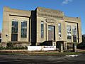
Leatherhead Institute
.jpg)
The Leatherhead Institute was built in 1892. It was given to the town by Abraham Dixon, who wanted the building to be used to provide educational, social and recreational opportunities to local residents. During the Second World War, it housed the local Food and Fuel Offices. A major restoration project was completed in 1987.
Running Horse pub

The Running Horse pub, at the east end of Leatherhead Bridge, is one of the oldest buildings in the town. It is a late-medieval open hall house and was part of the Manor of Thorncroft. Much of the timber frame is original and probably dates from the late 15th century, although the roof was later rebuilt. Later alterations include the insertion of the first floor in the 17th century and installation of interior panelling in the 18th century.
Sweech House
The timber-framed Sweech House, on Gravel Hill, is one of the oldest buildings in Leatherhead. Its name is thought to derive from "switch", indicating that it stood close to a road junction. The land on which it stands may have belonged to the manor of Minchin during the late-medieval period. The southernmost part of the building is the oldest and dates from the 15th century. It was probably constructed as a farmhouse and originally it had an open hall structure. In the late 16th century, it was extended to the north in two separate phases. At different points in its history, the building has been divided into up to four cottages, most likely to provide accommodation for farm labourers. Sweech House was donated to the Leatherhead Countryside Protection Society in the 1940s.
The Mansion
.jpg)
The Mansion, in Church Street, houses the public library, register office and council offices. A map of the town from 1600 shows a house on the site, which may formerly have been the manor house for the manor of Michin. During the late Elizabethan period, it was the home of Edmund Tylney, Master of the Revels, in effect the official censor of the time. and Elizabeth I is thought to have dined with him in Leatherhead in August 1591.
The external appearance of The Mansion largely dates from 1739, when the house was rebuilt in red brick, although a partial remodelling took place c. 1810. From 1846 until some point in the 1870s, the building was used as a boarding and day school for around 50 boys, who were taught using the Jacotot education system. In 1949, The Mansion was subject to a compulsory purchase order and was acquired by Surrey County Council and Leatherhead UDC for use as a health clinic and the public library. During a refurbishment in 2000, the library was moved from the ground floor to the south range and the space released was repurposed for the Registry Office.
Thorncroft Manor house
The current Thorncroft Manor house was designed c. 1763 by the architect, Robert Taylor, for the politician and businessman, Henry Crabb-Boulton. It is built in a Neo-Palladian style, influenced by the early Rennaissence, with light Rococo ornamentation. The building was enlarged with the addition of a rear wing in 1789, possibly designed by George Gwilt. The engineering firm, Howard Humphries & Sons, purchased the house in 1971 and subsequently constructed additional office space, glazed with reflective glass.
War Memorial

The War Memorial in North Street was designed by Stock, Page and Stock, a London firm of architects and was dedicated in April 1921. It consists of a long, single-storey building with 11 open arches, constructed of brick and flint. The arches face a terraced garden, in which there is a free-standing cross made of Portland stone. The land on which the memorial stands was given to the town by Charles Leach, who funded much of the building work and whose son had been a second lieutenant in the Scots Guards. In total, 186 names are inscribed on stone tablets inside the cloister-like structure, of whom 117 died in the First World War. The memorial is protected by a Grade II listing.
Wesley House
The art-deco Wesley House, on Bull Hill, was built in 1935 as the offices of the Leatherhead Urban District Council (UDC). It was designed by the architects C.H. Rose and H.R. Gardner and was constructed of red brick. The original council chamber is preserved at the rear of the property. Wesley House was vacated by the UDC in 1983, when it became part of Mole Valley District Council.
Images for kids
-
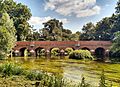
Leatherhead Town Bridge over the River Mole
-
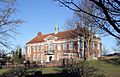
Wesley House, Bull Hill, the former headquarters of the Leatherhead UDC
-
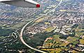
The M25 motorway at Leatherhead
-
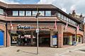
Swan shopping centre
-
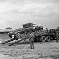
A Valentine tank at the Goblin plant, Leatherhead, 10 June 1942
-
The Leatherhead pumping station was constructed in 1935 by the East Surrey Water Company.
-
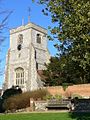
Tower of St Mary and St Nicholas Church
-
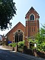
Methodist Church, Church Road
-
Leatherhead Museum
-
Garden at the rear of The Mansion


.jpg)


.jpg)

See also
 In Spanish: Leatherhead para niños
