
Leavenworth, Washington facts for kids
Quick facts for kids
Leavenworth
|
|
|---|---|

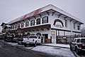
Leavenworth's main street reflects its modelling on a Bavarian village
|
|

Location of Leavenworth, Washington
|
|
| Country | United States |
| State | Washington |
| County | Chelan |
| Established | 1885 |
| Incorporated | September 5, 1906 |
| Area | |
| • Total | 1.47 sq mi (3.81 km2) |
| • Land | 1.45 sq mi (3.76 km2) |
| • Water | 0.02 sq mi (0.05 km2) |
| Elevation | 1,171 ft (357 m) |
| Population
(2010)
|
|
| • Total | 1,965 |
| • Estimate
(2019)
|
2,029 |
| • Density | 1,396.42/sq mi (539.20/km2) |
| Time zone | UTC-8 (PST) |
| • Summer (DST) | UTC-7 (PDT) |
| ZIP code |
98826
|
| Area code | 509 |
| FIPS code | 53-38845 |
| GNIS feature ID | 1521981 |
| Website | City of Leavenworth |
Leavenworth is a city in Chelan County, Washington, United States. It is part of the Wenatchee−East Wenatchee Metropolitan Statistical Area. The population was 1,965 at the 2010 census. The entire town center is modeled on a German Bavarian village as part of a civic initiative that began in the 1960s. The area is a major, four-season tourist destination with festivals nearly every month and a multitude of events year round.
Contents
Geography
Leavenworth's geographic coordinates are 47°35′47″N 120°39′55″W / 47.59639°N 120.66528°W.
According to the United States Census Bureau, the city has a total area of 1.25 square miles (3.24 km2), of which, 1.23 square miles (3.19 km2) is land and 0.02 square miles (0.05 km2) is water.
Geology
Leavenworth sits on the southeast side of the North Cascades collage, which is a group of terranes that accreted to North America all about the same time. Marine fossils indicate that the terranes were probably a group of islands originating out in the South Pacific hundreds of million years ago. The terranes landed on North America about 90mya(million years ago) in the middle of the Cretaceous period. As they smashed into their new home they were a puzzle of north- south slices. As accretion continued they were cut into horizontal (east-west) slices.
During the Eocene epoch, about 50 mya the area was once again cut into vertical slices, creating among others, the Leavenworth fault and the Entiat fault. In between these two faults the Chiwaukum graben was created. ( A graben is a large block of rock that drops between two normal faults). This graben is about 12 miles wide and trends northwest from Wenatchee for about 50 miles. As the graben dropped, it immediately began to fill with clastic sediment from the surrounding hills,creating the Chumstick formation. About 30 mya in the Oligocene epoch the Chiwaukum graben underwent compressional deformation creating several folds in the region, which are visible today. Leavenworth is on the western edge of the graben, in fact the Leavenworth fault runs through the western edge of town. The middle Cretaceous was when the area to the west and southwest of Leavenworth was created, this was the uplift of the Mt.Stuart batholith, forming the granite rock which we see today in Icicle Ridge and Tumwater Mountain.
During the Pleistocene and on into the Holocene epoch Leavenworth would have been a cold place to live. An alpine glacier originating from the southwest in the Mt. Stuart range made its way to where the town is today. Leavenworth actually sits on the terminal moraine of that glacier. A drive through the residential parts of town display many glacier erratic's that originated 20 miles away up the Icicle valley near Mt.Stuart.
About 19,000 years ago a large rock slide dammed the Columbia River near Rock Island (just south of Wenatchee). The temporary dam, in conjunction with one of the Lake Missoula floods, caused the water to flow back up the Wenatchee valley where it was stopped by the glacier at Leavenworth. As the leading edge of the glacier interacted with the flood, ice rafts formed carrying granite erratics from the Stuart batholith ending up in the town of Dryden about 15 miles down valley from Leavenworth. As the glacier retreated, the south side of Leavenworth was a lake dammed up by the moraine. The bridge on the east side of town is a good vantage point to see where the Wenatchee River cuts through the moraine today.
Climate
Leavenworth has a continental Mediterranean climate (Köppen Dsb) with summers characterised by hot, sunny days and chilly nights, and cold, snowy winters.
During the summer, the weather is typically anticyclonic due to the presence of the North Pacific anticyclone, with resultant clear skies and large diurnal temperature ranges. Rainfall is limited by the Cascade rain shadow as well as by the anticyclone, and all months from May to October have recorded zero precipitation on occasions: indeed from June 15 to October 6 of 2003 there were 114 consecutive days with not even a trace of precipitation. When a continental flow enters the Columbia Basin, temperature can be very hot during the day, with the hottest temperature being 110 °F or 43.3 °C during the heatwave of July 1941. However, on cooler, stiller days, summer nights can still be cold and frosts have been recorded as early as August 29 of 1980.
The fall months see steady cooling and a gradual increase in the frequency of frontal storms producing rainfall, whilst winter weather is typically cold and snowy, with an annual mean snowfall of 90.1 inches or 2.29 metres and a maximum monthly total of 92.3 inches (2.34 m) during December 1996. The snowiest season has been from July 1968 to June 1969 with 217.2 inches (5.52 m) and the least snowy from July 1962 to June 1963 when just 19.4 inches (0.49 m) of snow fell. On occasions, as in January and February 1929, and Januaries 1930, 1937, 1949, 1950, 1957 and 1969, very cold and dry Arctic air from western Canada can invade the basin, turning the weather much colder and frequently clearer: the lowest temperature recorded in Leavensworth has been −36 °F (−37.8 °C) on December 30, 1968, though only 5.5 mornings will fall to or below 0 °F or −17.8 °C and numerous mild winters never see such cold temperatures.
The wettest “rain year” has been from July 1955 to June 1956 with a total of 41.13 inches (1,044.7 mm) and the driest from July 1929 to June 1930 with 11.77 inches (299.0 mm). The spring months see gradual warming and drying, though frosts remain frequent into April – over 168 mornings during an average year fall to or below freezing and the average last freeze is on May 16, with 2016 became the first year to record a last frost in March.
| Climate data for Leavenworth, Washington (1971-2000; extremes since 1914) | |||||||||||||
|---|---|---|---|---|---|---|---|---|---|---|---|---|---|
| Month | Jan | Feb | Mar | Apr | May | Jun | Jul | Aug | Sep | Oct | Nov | Dec | Year |
| Record high °F (°C) | 64 (18) |
65 (18) |
79 (26) |
92 (33) |
101 (38) |
105 (41) |
110 (43) |
108 (42) |
104 (40) |
91 (33) |
74 (23) |
60 (16) |
110 (43) |
| Average high °F (°C) | 33.9 (1.1) |
42.0 (5.6) |
52.4 (11.3) |
62.4 (16.9) |
71.4 (21.9) |
78.7 (25.9) |
87.1 (30.6) |
87.6 (30.9) |
78.5 (25.8) |
64.2 (17.9) |
44.0 (6.7) |
33.7 (0.9) |
61.3 (16.3) |
| Average low °F (°C) | 17.2 (−8.2) |
21.6 (−5.8) |
27.3 (−2.6) |
33.4 (0.8) |
40.1 (4.5) |
46.3 (7.9) |
50.6 (10.3) |
50.2 (10.1) |
41.7 (5.4) |
32.8 (0.4) |
27.4 (−2.6) |
19.5 (−6.9) |
34.0 (1.1) |
| Record low °F (°C) | −27 (−33) |
−25 (−32) |
−6 (−21) |
19 (−7) |
24 (−4) |
31 (−1) |
34 (1) |
30 (−1) |
19 (−7) |
11 (−12) |
−10 (−23) |
−36 (−38) |
−36 (−38) |
| Average precipitation inches (mm) | 4.40 (112) |
3.23 (82) |
2.09 (53) |
1.10 (28) |
0.85 (22) |
0.84 (21) |
0.39 (9.9) |
0.58 (15) |
0.75 (19) |
1.74 (44) |
4.27 (108) |
4.83 (123) |
25.07 (636.9) |
| Average snowfall inches (cm) | 27.9 (71) |
15.3 (39) |
5.1 (13) |
0.3 (0.76) |
0.0 (0.0) |
0.0 (0.0) |
0.0 (0.0) |
0.0 (0.0) |
0.0 (0.0) |
0.4 (1.0) |
9.8 (25) |
31.3 (80) |
90.1 (229.76) |
| Average precipitation days (≥ 0.01 inch) | 15.4 | 12.8 | 11.2 | 7.1 | 6.6 | 6.1 | 3.5 | 3.7 | 4.6 | 8.8 | 15.2 | 15.5 | 110.5 |
| Average snowy days (≥ 0.1 inch) | 9.2 | 5.1 | 2.0 | 0.1 | 0.0 | 0.0 | 0.0 | 0.0 | 0.0 | 0.2 | 3.8 | 9.1 | 29.5 |
| Source 1: National Oceanic and Atmospheric Administration | |||||||||||||
| Source 2: National Weather Service (extremes) | |||||||||||||
Demographics
| Historical population | |||
|---|---|---|---|
| Census | Pop. | %± | |
| 1910 | 1,551 | — | |
| 1920 | 1,791 | 15.5% | |
| 1930 | 1,415 | −21.0% | |
| 1940 | 1,608 | 13.6% | |
| 1950 | 1,503 | −6.5% | |
| 1960 | 1,480 | −1.5% | |
| 1970 | 1,322 | −10.7% | |
| 1980 | 1,522 | 15.1% | |
| 1990 | 1,692 | 11.2% | |
| 2000 | 2,074 | 22.6% | |
| 2010 | 1,965 | −5.3% | |
| 2019 (est.) | 2,029 | 3.3% | |
| U.S. Decennial Census 2015 Estimate |
|||
As of the 2010 U.S. Census, there were 1,965 people, 908 households, and 500 families residing in the city. The population density was about 1,598 inhabitants per square mile (617.0/km2). There were 1,241 housing units at an average density of about 1,009 per square mile (389.6/km2). The racial makeup of the city was 92.9% White, 0.4% Black, 0.5% Native American, 0.6% Asian, 0.2% Pacific Islander, 3.9% from other races, and 1.6% from two or more races. Hispanic or Latino of any race were 10.8% of the population.
There were 908 households, of which about 24% had children under the age of 18 living with them, about 42% were married couples living together, about 10% had a female householder with no husband present, 3% had a male householder with no wife present, and about 45% were non-families. About 37% of all households were made up of individuals, and about 20% had someone living alone who was 65 years of age or older. The average household size was 2.16 and the average family size was 2.84.
The median age in the city was about 42 years. About 20% of residents were under the age of 18; about 8% were between the ages of 18 and 24; 25% were from 25 to 44; about 27% were from 45 to 64; and about 20% were 65 years of age or older. The gender makeup of the city was 46.7% male and 53.3% female.
Infrastructure
Transportation
Leavenworth is located on U.S. Route 2, which continues west across Stevens Pass to Snohomish County and east towards Wenatchee. The Chumstick Highway, formerly known as State Route 209, travels north from Leavenworth to Plain and Lake Wenatchee State Park.
The city is served by Amtrak's Empire Builder train, which stops daily at Icicle Station near downtown. Link Transit provides local and inter-city public transit services that connect Leavenworth to Wenatchee, as well as local paratransit and a downtown shuttle. The city also has several private taxi companies and inter-city bus operators, including stops for Northwestern Trailways and Amtrak Thruway Motorcoach.
Education
Public schools in Leavenworth and the surrounding area are operated by the Cascade School District, which has over 1,300 students. The district has one high school, located in Leavenworth, that was rebuilt in 2019.
Leavenworth is home to the Upper Valley Christian School, which is a private, K-12 school operated by the Leavenworth Church of the Nazarene.
Images for kids
-
Bavarian Ritz Hotel
-
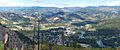
Downtown Leavenworth, 1,500 feet (460 m) below, as viewed from the adjacent Tumwater Mountain on an August afternoon
.jpg)

See also
 In Spanish: Leavenworth (Washington) para niños
