
Lebanon, New Jersey facts for kids
Quick facts for kids
Lebanon, New Jersey
|
|
|---|---|
|
Borough
|
|
| Borough of Lebanon | |

Lebanon Reformed Church
|
|

Map of Lebanon in Hunterdon County. Inset: Location of Hunterdon County highlighted in the State of New Jersey.
|
|

Census Bureau map of Lebanon, New Jersey
|
|

Lebanon, New Jersey
Location in Hunterdon County, New Jersey

Lebanon, New Jersey
Location in New Jersey

Lebanon, New Jersey
Location in the United States
|
|
| Country | |
| State | |
| County | |
| Incorporated | April 20, 1926 |
| Government | |
| • Type | Borough |
| • Body | Borough Council |
| Area | |
| • Total | 0.90 sq mi (2.34 km2) |
| • Land | 0.90 sq mi (2.34 km2) |
| • Water | 0.00 sq mi (0.00 km2) 0.00% |
| Area rank | 514th of 565 in state 25th of 26 in county |
| Elevation | 246 ft (75 m) |
| Population | |
| • Total | 1,358 |
| • Estimate
(2019)
|
1,644 |
| • Rank | 522nd of 566 in state 22nd of 26 in county |
| • Density | 1,532.0/sq mi (591.5/km2) |
| • Density rank | 333rd of 566 in state 4th of 26 in county |
| Time zone | UTC−05:00 (Eastern (EST)) |
| • Summer (DST) | UTC−04:00 (Eastern (EDT)) |
| ZIP Code |
08833
|
| Area code(s) | 908 Exchanges: 236,437 |
| FIPS code | 3401939630 |
| GNIS feature ID | 0885275 |
| Website | |
Lebanon is a borough in Hunterdon County, New Jersey, United States. As of the 2010 United States Census, the borough's population was 1,358, reflecting an increase of 293 (+27.5%) from the 1,065 counted in the 2000 Census, which had in turn increased by 29 (+2.8%) from the 1,036 counted in the 1990 Census.
Lebanon was incorporated as a borough by an act of the New Jersey Legislature on March 26, 1926, from portions of Clinton Township, based on the results of a referendum held on April 20, 1926. Additional portions of Clinton Township were annexed in 1962.
The borough is located north of the Round Valley Reservoir. The Borough was known in the early part of the 19th century as Jacksonville and later as Lebanonville, Lebanonville Depot and finally Lebanon, a station on the Central Railroad of New Jersey. The center of Lebanon has changed little in the past century. The Dutch Reformed Church is one of the oldest churches in the County. Records of the church begin in 1769, however, the church is cited as early as 1747. The Lebanon Historic District was listed on the state and national registers of historic places in 2009.
Contents
Geography
According to the United States Census Bureau, the borough had a total area of 0.886 square miles (2.297 km2), including 0.886 square miles (2.296 km2) of land and less than 0.001 square miles (0.001 km2) of water (0.04%).
The borough is an independent municipality surrounded by Clinton Township, making it part one of 21 pairs of "doughnut towns" in the state, where one municipality entirely surrounds another.
Demographics
| Historical population | |||
|---|---|---|---|
| Census | Pop. | %± | |
| 1930 | 550 | — | |
| 1940 | 638 | 16.0% | |
| 1950 | 752 | 17.9% | |
| 1960 | 880 | 17.0% | |
| 1970 | 885 | 0.6% | |
| 1980 | 820 | −7.3% | |
| 1990 | 1,036 | 26.3% | |
| 2000 | 1,065 | 2.8% | |
| 2010 | 1,358 | 27.5% | |
| 2019 (est.) | 1,644 | 21.1% | |
| Population sources: 1930 1930-1990 2000 2010 |
|||
Census 2010
As of the census of 2010, there were 1,358 people, 602 households, and 366 families residing in the borough. The population density was 1,532.0 per square mile (591.5/km2). There were 664 housing units at an average density of 749.1 per square mile (289.2/km2)*. The racial makeup of the borough was 90.13% (1,224) White, 1.77% (24) Black or African American, 0.15% (2) Native American, 5.23% (71) Asian, 0.00% (0) Pacific Islander, 0.88% (12) from other races, and 1.84% (25) from two or more races. [[Hispanic (U.S. Census)|Hispanic or Latino of any race were 5.01% (68) of the population.
There were 602 households out of which 28.6% had children under the age of 18 living with them, 46.5% were married couples living together, 10.5% had a female householder with no husband present, and 39.2% were non-families. 34.2% of all households were made up of individuals, and 13.1% had someone living alone who was 65 years of age or older. The average household size was 2.26 and the average family size was 2.93.
In the borough, the population was spread out with 21.1% under the age of 18, 6.4% from 18 to 24, 30.5% from 25 to 44, 28.9% from 45 to 64, and 13.2% who were 65 years of age or older. The median age was 40.2 years. For every 100 females there were 84.8 males. For every 100 females ages 18 and old there were 82.6 males. The Census Bureau's 2006-2010 American Community Survey showed that (in 2010 inflation-adjusted dollars) median household income was $71,629 (with a margin of error of +/- $5,410) and the median family income was $96,500 (+/- $10,275). Males had a median income of $70,977 (+/- $9,418) versus $53,750 (+/- $18,758) for females. The per capita income for the borough was $37,035 (+/- $2,975). About 1.5% of families and 2.8% of the population were below the poverty line, including 1.3% of those under age 18 and 1.8% of those age 65 or over.
Census 2000
As of the 2000 United States Census there were 1,065 people, 458 households, and 287 families residing in the borough. The population density was 1,227.3 people per square mile (472.6/km2). There were 477 housing units at an average density of 549.7 per square mile (211.7/km2). The racial makeup of the borough was 95.40% White, 0.66% African American, 0.19% Native American, 3.10% Asian, 0.38% from other races, and 0.28% from two or more races. Hispanic or Latino of any race were 2.07% of the population.
There were 458 households, out of which 30.8% had children under the age of 18 living with them, 50.4% were married couples living together, 9.6% had a female householder with no husband present, and 37.3% were non-families. 33.0% of all households were made up of individuals, and 10.5% had someone living alone who was 65 years of age or older. The average household size was 2.33 and the average family size was 2.97.
In the borough the population was spread out, with 24.1% under the age of 18, 3.7% from 18 to 24, 35.1% from 25 to 44, 25.4% from 45 to 64, and 11.6% who were 65 years of age or older. The median age was 39 years. For every 100 females, there were 92.2 males. For every 100 females age 18 and over, there were 82.4 males.
The median income for a household in the borough was $68,542, and the median income for a family was $83,436. Males had a median income of $52,316 versus $37,396 for females. The per capita income for the borough was $34,066. About 0.7% of families and 3.6% of the population were below the poverty line, including 2.0% of those under age 18 and 5.1% of those age 65 or over.
Transportation
_from_the_overpass_for_Hunterdon_County_Route_639_(Cokesbury_Road)_in_Lebanon,_Hunterdon_County,_New_Jersey.jpg)
Roads and highways
As of May 2010[update], the borough had a total of 7.08 miles (11.39 km) of roadways, of which 4.52 miles (7.27 km) were maintained by the municipality, 0.33 miles (0.53 km) by Hunterdon County and 2.23 miles (3.59 km) by the New Jersey Department of Transportation.
U.S. Route 22 passes through the center of town. Interstate 78 runs through the northern part with Exit 20 within its borders.
Public transportation
The Lebanon station offers service on NJ Transit's Raritan Valley Line. There is a station building on the south side of the tracks. The northern track is no longer in use and the stop has limited weekday and no weekend service.
Points of interest
- Hunterdon County Arboretum
- Round Valley Reservoir
- Cushetunk Mountain
- Lebanon Borough School District's 2014–15 School Report Card from the New Jersey Department of Education
Education
Students in pre-kindergarten through sixth grade for public school are served by the Lebanon Borough School District at Lebanon Borough School. As of the 2018–19 school year, the district, comprised of one school, had an enrollment of 40 students and 13.8 classroom teachers (on an FTE basis), for a student–teacher ratio of 2.9:1. In the 2016–17 school year, Lebanon had the 9th-smallest enrollment of any school district in the state, with 101 students.
Students in seventh and eighth grades attend Clinton Township Middle School in Clinton Township as part of a sending/receiving relationship with the Clinton Township School District. As of the 2018–19 school year, the high school had an enrollment of 479 students and 57.0 classroom teachers (on an FTE basis), for a student–teacher ratio of 8.4:1.
Public school students in ninth through twelfth grades attend North Hunterdon High School in Annandale together with students from Bethlehem Township, Clinton Town, Clinton Township, Franklin Township and Union Township. As of the 2018–19 school year, the high school had an enrollment of 1,584 students and 123.2 classroom teachers (on an FTE basis), for a student–teacher ratio of 12.9:1. The school is part of the North Hunterdon-Voorhees Regional High School District, which also includes students from Califon, Glen Gardner, Hampton, High Bridge, Lebanon Township and Tewksbury Township, who attend Voorhees High School in Lebanon Township.
Eighth grade students from all of Hunterdon County are eligible to apply to attend the high school programs offered by the Hunterdon County Vocational School District, a county-wide vocational school district that offers career and technical education at its campuses in Raritan Township and at programs sited at local high schools, with no tuition charged to students for attendance.
Notable people
People who were born in, residents of, or otherwise closely associated with Lebanon include:
- Alvah A. Clark (1840–1912), represented New Jersey's 4th congressional district in the United States House of Representatives from 1877 to 1881.
- James N. Pidcock (1836–1899), represented New Jersey's 4th congressional district in the United States House of Representatives from 1885 to 1889.
Images for kids
-
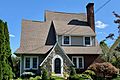
Tudor Revival style house
-
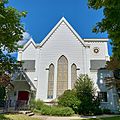
Round Valley United Methodist Church


See also
 In Spanish: Lebanon (Nueva Jersey) para niños
