
Lee County, Illinois facts for kids
Quick facts for kids
Lee County
|
|
|---|---|

Lee County Courthouse
|
|

Location within the U.S. state of Illinois
|
|
 Illinois's location within the U.S. |
|
| Country | |
| State | |
| Founded | February 27, 1839 |
| Named for | Henry Lee III |
| Seat | Dixon |
| Largest city | Dixon |
| Area | |
| • Total | 729 sq mi (1,890 km2) |
| • Land | 725 sq mi (1,880 km2) |
| • Water | 4.1 sq mi (11 km2) 0.6% |
| Population
(2010)
|
|
| • Total | 36,031 |
| • Estimate
(2018)
|
34,223 |
| • Density | 49.43/sq mi (19.083/km2) |
| Time zone | UTC−6 (Central) |
| • Summer (DST) | UTC−5 (CDT) |
| Congressional district | 16th |
Lee County is a county located in the U.S. state of Illinois. According to the 2010 census, it has a population of 36,031. Its county seat is Dixon.
The Dixon, IL Micropolitan Statistical Area includes all of Lee County.
Contents
History
Lee County was formed in 1839 out of Ogle County. The County is named in honor of Lighthorse Harry Lee, officer in the Revolutionary War, or Richard Henry Lee, member of the Continental Congress. The Declaration of Independence was adopted pursuant to the Lee Resolution. President Ronald Reagan lived in Dixon as a boy and attended Dixon High School.
-
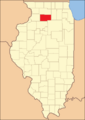
Lee County's boundaries have remained unchanged since its creation in 1839

Geography
According to the U.S. Census Bureau, the county has a total area of 729 square miles (1,890 km2), of which 725 square miles (1,880 km2) is land and 4.1 square miles (11 km2) (0.6%) is water.
Climate and weather
| Weather chart for Dixon, Illinois | |||||||||||||||||||||||||||||||||||||||||||||||
|---|---|---|---|---|---|---|---|---|---|---|---|---|---|---|---|---|---|---|---|---|---|---|---|---|---|---|---|---|---|---|---|---|---|---|---|---|---|---|---|---|---|---|---|---|---|---|---|
| J | F | M | A | M | J | J | A | S | O | N | D | ||||||||||||||||||||||||||||||||||||
|
1.6
26
10
|
1.4
32
15
|
2.6
44
27
|
3.6
58
37
|
4.3
70
48
|
4.9
79
58
|
3.5
82
62
|
4.5
80
60
|
3.3
73
51
|
2.7
62
39
|
2.8
45
28
|
2.1
31
17
|
||||||||||||||||||||||||||||||||||||
| temperatures in °F precipitation totals in inches source: The Weather Channel |
|||||||||||||||||||||||||||||||||||||||||||||||
|
Metric conversion
|
|||||||||||||||||||||||||||||||||||||||||||||||
In recent years, average temperatures in the county seat of Dixon have ranged from a low of 10 °F (−12 °C) in January to a high of 82 °F (28 °C) in July, although a record low of −27 °F (−33 °C) was recorded in January 1999 and a record high of 110 °F (43 °C) was recorded in July 1936. Average monthly precipitation ranged from 1.43 inches (36 mm) in February to 4.88 inches (124 mm) in June.
Major highways
 Interstate 39
 Interstate 88
 U.S. Highway 30
 U.S. Highway 51
 U.S. Highway 52
 Illinois Route 2
 Illinois Route 26
 Illinois Route 38
 Illinois Route 110
 Illinois Route 251
Other features
- Green River Ordinance Plant
- Mendota Hills Wind Farm
Demographics
| Historical population | |||
|---|---|---|---|
| Census | Pop. | %± | |
| 1840 | 2,035 | — | |
| 1850 | 5,292 | 160.0% | |
| 1860 | 17,651 | 233.5% | |
| 1870 | 27,171 | 53.9% | |
| 1880 | 27,491 | 1.2% | |
| 1890 | 26,187 | −4.7% | |
| 1900 | 29,894 | 14.2% | |
| 1910 | 27,750 | −7.2% | |
| 1920 | 28,004 | 0.9% | |
| 1930 | 32,329 | 15.4% | |
| 1940 | 34,604 | 7.0% | |
| 1950 | 36,451 | 5.3% | |
| 1960 | 38,749 | 6.3% | |
| 1970 | 37,947 | −2.1% | |
| 1980 | 36,328 | −4.3% | |
| 1990 | 34,392 | −5.3% | |
| 2000 | 36,062 | 4.9% | |
| 2010 | 36,031 | −0.1% | |
| 2018 (est.) | 34,223 | −5.0% | |
| US Decennial Census 1790-1960 1900-1990 1990-2000 2010-2013 |
|||
As of the 2010 United States Census, there were 36,031 people, 13,758 households, and 9,064 families residing in the county. The population density was 49.7 inhabitants per square mile (19.2/km2). There were 15,049 housing units at an average density of 20.8 per square mile (8.0/km2). The racial makeup of the county was 90.9% white, 4.8% black or African American, 0.7% Asian, 0.2% American Indian, 1.9% from other races, and 1.5% from two or more races. Those of Hispanic or Latino origin made up 5.0% of the population. In terms of ancestry, 38.0% were German, 18.8% were Irish, 8.4% were English, and 8.2% were American.
Of the 13,758 households, 30.0% had children under the age of 18 living with them, 51.2% were married couples living together, 10.0% had a female householder with no husband present, 34.1% were non-families, and 28.8% of all households were made up of individuals. The average household size was 2.41 and the average family size was 2.94. The median age was 42.0 years.
The median income for a household in the county was $48,502 and the median income for a family was $60,759. Males had a median income of $42,114 versus $30,920 for females. The per capita income for the county was $24,440. About 7.6% of families and 9.6% of the population were below the poverty line, including 11.8% of those under age 18 and 6.5% of those age 65 or over.
Communities

Cities
Villages
Townships
Lee County is divided into twenty-two townships:
- Alto
- Amboy
- Ashton
- Bradford
- Brooklyn
- China
- Dixon
- East Grove
- Hamilton
- Harmon
- Lee Center
- Marion
- May
- Nachusa
- Nelson
- Palmyra
- Reynolds
- South Dixon
- Sublette
- Viola
- Willow Creek
- Wyoming
See also
 In Spanish: Condado de Lee (Illinois) para niños
