
Leeming, Western Australia facts for kids
Quick facts for kids LeemingPerth, Western Australia |
|||||||||||||||
|---|---|---|---|---|---|---|---|---|---|---|---|---|---|---|---|

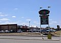
Leeming recreation centre entrance
|
|||||||||||||||
| Population | 10,730 (2016 census) | ||||||||||||||
| • Density | 1,431/km2 (3,710/sq mi) | ||||||||||||||
| Postcode(s) | 6149 | ||||||||||||||
| Area | 7.5 km2 (2.9 sq mi) | ||||||||||||||
| Location | 17 km (11 mi) from Perth | ||||||||||||||
| LGA(s) | City of Melville City of Cockburn City of Canning |
||||||||||||||
| State electorate(s) | Jandakot, Riverton | ||||||||||||||
| Federal Division(s) | Tangney | ||||||||||||||
|
|||||||||||||||
Leeming is a southern suburb of Perth, Western Australia. It is divided between the three local government areas of the City of Melville, the City of Cockburn (south) and the City of Canning (north-east). It is located approximately 17 kilometres (11 mi) south of the Perth central business district and 13 kilometres (8.1 mi) east of Fremantle.
Contents
History
The area was previously part of Jandakot and was predominantly agricultural until the 1970s, having been laid out by a surveyor, George Waters Leeming (1857-1902), in 1886. Three roads - King Road, Leeming Road (the southern boundary) and Beasley Road - accessed the area. In 1971, the suburb of Leeming was gazetted, although construction did not commence until approximately 1976 (possibly as early as 1975). It was built in stages, with the area between Findlay Road and Gracechurch Crescent being built first, while the east, west and south were built in that order over the next ten years. Many of the streets were named after original landowners in the agricultural district.
Geography
Leeming is bounded by South Street to the north, Kwinana Freeway to the west, Roe Highway and to the south and southeast. The 53-ha Ken Hurst Park, a conservation bushland area beyond Roe Highway named for a former mayor of Melville (1971–73) and set aside in the early 1990s, is also within the suburb's boundaries.
At the ABS 2001 census, Leeming had a mostly upper-middle income population of 12,977 people living in 3,959 dwellings, all but 230 of which were detached houses on separate lots. About 10% of the population are of East or South-East Asian descent. Retail and property and business services are the two most common occupations.
Facilities
Educational
Leeming contains three primary schools - Leeming (1982), West Leeming (1986) and Banksia Park (1989), and one high school, Leeming Senior High School (1985).
Commercial
Leeming has two shopping centres:
- Leeming Shopping Forum, on the corner of Farrington and Findlay Roads
- Leeming Park Shopping Centre, on the corner of Beasley Road and Dundee Street
Other commercial services are provided by Stockland Bull Creek on its northern fringe, and Southlands Boulevarde in Willetton.
Recreation and community
The suburb also contains a family centre, a recreation centre and sports facilities ("The Rec"), the Leeming Spartan Cricket Club, the Leeming Bowling Club and the Melville Glades Golf Club.
Murdoch University, Murdoch TAFE (a campus of Challenger TAFE) and St John of God Hospital are 2 km to the west.
Transport
The suburb is located next to Murdoch train station, which opened in 2007. All services are operated by the Public Transport Authority.
Jandakot Airport is 2 km to the south-east.
Images for kids
-
Leeming Shopping Forum on Farrington Road.
-
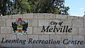
Leeming Recreation Centre sign on Farrington Road.
-
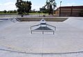
Leeming skate park in 2006. Since 2007, the park has been repainted with street art, under a plan known as "Phaze" organised by the local council.


