Leer (district) facts for kids
Quick facts for kids
Leer
|
|||
|---|---|---|---|
|
|||
| Country | |||
| State | Lower Saxony | ||
| Capital | Leer | ||
| Area | |||
| • Total | 1,086 km2 (419 sq mi) | ||
| Population
(2002)
|
|||
| • Total | 163,800 | ||
| • Density | 150.83/km2 (390.64/sq mi) | ||
| Time zone | UTC+1 (CET) | ||
| • Summer (DST) | UTC+2 (CEST) | ||
| Vehicle registration | LER | ||
| Website | landkreis-leer.de | ||
Leer is a district (Landkreis) in Lower Saxony, Germany.
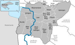
The District is located in the southern part of East Frisia. The Ems River runs through the District, coming out of the Emsland in the south and flowing into the Dollart, a bay of the North Sea. The island of Borkum, belonging to the East Frisian Islands, is also a part of the District. Some of the area of the District is in the Lower Saxony Wadden Sea National Park.
Cities and municipalities
| Cities | Samtgemeinden |
|---|---|
|
|
|
| 1seat of the Samtgemeinde |
Unincorporated Area
The uninhabited island Lütje Hörn is also part of Leer district, but not part of any municipality (unincorporated area).
See also
 In Spanish: Distrito de Leer para niños

All content from Kiddle encyclopedia articles (including the article images and facts) can be freely used under Attribution-ShareAlike license, unless stated otherwise. Cite this article:
Leer (district) Facts for Kids. Kiddle Encyclopedia.


