
Lehigh County, Pennsylvania facts for kids
Quick facts for kids
Lehigh County
|
||
|---|---|---|

Old Lehigh County Courthouse in Allentown, 2011
|
||
|
||

Location within the U.S. state of Pennsylvania
|
||
 Pennsylvania's location within the U.S. |
||
| Country | ||
| State | ||
| Founded | March 6, 1812 | |
| Named for | Lehigh River | |
| Seat | Allentown | |
| Largest city | Allentown | |
| Area | ||
| • Total | 348 sq mi (900 km2) | |
| • Land | 345 sq mi (890 km2) | |
| • Water | 3.1 sq mi (8 km2) 0.9%% | |
| Population | ||
| • Estimate
(2019)
|
369,318 | |
| • Density | 1,046/sq mi (404/km2) | |
| Time zone | UTC−5 (Eastern) | |
| • Summer (DST) | UTC−4 (EDT) | |
| Congressional district | 7th | |

Lehigh County (Pennsylvania Dutch: Lechaa Kaundi) is a county located in the Lehigh Valley region of the U.S. state of Pennsylvania, in the United States. As of the 2020 census, the county's population was 374,557. Its county seat is Allentown, the state's third-largest city behind Philadelphia and Pittsburgh.
Lehigh County falls geographically between two Pennsylvania Appalachian mountain ridges, the Blue Mountain ridge to the county's north and South Mountain to its south. The county is approximately 48 miles (77 km) north-northwest of Philadelphia and 78 miles (126 km) west of New York City.
Lehigh County is the most populated of the four counties that comprise the Lehigh Valley region of eastern Pennsylvania and northwestern New Jersey. It is one of the fastest-growing counties in Pennsylvania and part of the Philadelphia media market, the nation's fourth largest television market.
Contents
Geography
According to the U.S. Census Bureau, the county has a total area of 348 square miles (900 km2), of which 345 square miles (890 km2) is land and 3.1 square miles (8.0 km2) (0.9%) is water.
Topography

The Lehigh Valley, which includes all of Lehigh and Northampton counties, is bounded on the north by Blue Mountain, a ridge of the Appalachian mountain range with an altitude of 1,300 to 1,604 feet (489 m), and on the south by South Mountain, a ridge of 700 to 1,100 feet (340 m) that cuts through the southern portions of the two counties. The highest point in Lehigh County is Bake Oven Knob, a mass of Tuscarora conglomeratic rocks that rise about 100 feet (30 m) above the main ridge of the Blue Mountain in northwestern Heidelberg Township.
Lehigh County is in the Delaware River watershed. While most of the county is drained by the Lehigh River and its tributaries, the Schuylkill River also drains regions in the south of the county via the Perkiomen Creek and the northwest via the Maiden Creek.
Adjacent counties
- Berks County (west)
- Bucks County (southeast)
- Carbon County (north)
- Montgomery County (south)
- Northampton County (northeast)
- Schuylkill County (northwest)
Climate
Most of the county's climate is considered to fall in the humid continental climate zone. Summers are typically hot and muggy, fall and spring are generally mild, and winter is cold. Precipitation is almost uniformly distributed throughout the year.
For the city of Allentown, January lows average −6 °C (21 °F) and highs average 1.3 °C (34.3 °F). The lowest officially recorded temperature was −26.7 °C (−16.1 °F) in 1912 . July lows average 17.6 °C (63.7 °F) and highs average 29.2 °C (84.6 °F), with an average relative humidity (morning) of 82%. The highest temperature on record was 40.6 °C (105.1 °F) in 1966 . Early fall and mid winter are generally driest, with October being the driest month with only 74.7 mm of average precipitation.
Snowfall is variable, with some winters bringing light snow and others bringing numerous significant snowstorms. Average snowfall is 82.3 centimetres (32.4 in) per year, with the months of January and February receiving the highest at just over 22.86 centimetres (9.00 in) each. Rainfall is generally spread throughout the year, with eight to twelve wet days per month, at an average annual rate of 110.54 centimetres (43.52 in).
| Climate data for Allentown, Pennsylvania (Lehigh Valley Int'l), 1981–2010 normals, extremes 1922–present | |||||||||||||
|---|---|---|---|---|---|---|---|---|---|---|---|---|---|
| Month | Jan | Feb | Mar | Apr | May | Jun | Jul | Aug | Sep | Oct | Nov | Dec | Year |
| Record high °F (°C) | 72 (22) |
77 (25) |
87 (31) |
93 (34) |
97 (36) |
100 (38) |
105 (41) |
100 (38) |
99 (37) |
92 (33) |
81 (27) |
72 (22) |
105 (41) |
| Mean maximum °F (°C) | 57.9 (14.4) |
59.6 (15.3) |
71.6 (22.0) |
82.5 (28.1) |
88.2 (31.2) |
91.9 (33.3) |
94.2 (34.6) |
92.5 (33.6) |
88.0 (31.1) |
79.0 (26.1) |
70.6 (21.4) |
59.7 (15.4) |
95.4 (35.2) |
| Average high °F (°C) | 36.0 (2.2) |
39.8 (4.3) |
49.4 (9.7) |
61.3 (16.3) |
71.5 (21.9) |
80.1 (26.7) |
84.2 (29.0) |
82.4 (28.0) |
74.9 (23.8) |
63.6 (17.6) |
52.5 (11.4) |
40.5 (4.7) |
61.4 (16.3) |
| Average low °F (°C) | 19.5 (−6.9) |
21.7 (−5.7) |
28.8 (−1.8) |
38.5 (3.6) |
48.3 (9.1) |
58.1 (14.5) |
62.7 (17.1) |
60.9 (16.1) |
52.9 (11.6) |
41.3 (5.2) |
32.9 (0.5) |
24.0 (−4.4) |
40.8 (4.9) |
| Mean minimum °F (°C) | 3.0 (−16.1) |
5.7 (−14.6) |
13.1 (−10.5) |
26.0 (−3.3) |
35.5 (1.9) |
46.3 (7.9) |
52.6 (11.4) |
49.8 (9.9) |
39.2 (4.0) |
28.8 (−1.8) |
19.9 (−6.7) |
9.1 (−12.7) |
0.2 (−17.7) |
| Record low °F (°C) | −15 (−26) |
−12 (−24) |
−5 (−21) |
12 (−11) |
28 (−2) |
39 (4) |
46 (8) |
41 (5) |
30 (−1) |
21 (−6) |
3 (−16) |
−8 (−22) |
−15 (−26) |
| Average precipitation inches (mm) | 3.03 (77) |
2.70 (69) |
3.39 (86) |
3.56 (90) |
4.14 (105) |
4.31 (109) |
4.95 (126) |
3.69 (94) |
4.62 (117) |
3.88 (99) |
3.50 (89) |
3.58 (91) |
45.35 (1,152) |
| Average snowfall inches (cm) | 10.0 (25) |
11.1 (28) |
4.9 (12) |
1.0 (2.5) |
0 (0) |
0 (0) |
0 (0) |
0 (0) |
0 (0) |
0 (0) |
0.7 (1.8) |
5.2 (13) |
32.9 (84) |
| Average precipitation days (≥ 0.01 in) | 11.1 | 9.8 | 11.0 | 12.1 | 12.1 | 11.4 | 10.9 | 9.5 | 9.1 | 9.1 | 9.8 | 10.9 | 126.8 |
| Average snowy days (≥ 0.1 in) | 5.6 | 4.8 | 2.5 | 0.4 | 0 | 0 | 0 | 0 | 0 | 0 | 0.6 | 3.5 | 17.4 |
| Average relative humidity (%) | 69.1 | 66.7 | 62.6 | 60.9 | 65.6 | 67.9 | 68.8 | 71.9 | 74.0 | 71.8 | 70.5 | 71.4 | 68.4 |
| Source: NOAA (relative humidity 1961–1990) | |||||||||||||
Demographics
As of the 2010 census, the county was 71.6% White Non-Hispanic, 6.1% Black or African American, 0.4% Native American or Alaskan Native, 2.9% Asian, 0.0% Native Hawaiian, 2.9% were two or more races, and 8.6% were some other race. 18.8% of the population were of Hispanic or Latino ancestry.
As of the 2010 census, there were 312,090 people, 121,906 households, and 82,164 families residing in the county. The population density was 900 people per square mile (348/km2). There were 128,910 housing units at an average density of 372 per square mile (144/km2). The racial makeup of the county was 87.02% White, 3.56% Black or African American, 0.18% Native American, 2.10% Asian, 0.04% Pacific Islander, 5.28% from other races, and 1.83% from two or more races. 10.22% of the population were Hispanic or Latino of any race. 27.1% were of German, 7.9% Italian, 7.7% Irish, 6.2% Pennsylvania German and 5.6% American ancestry. 85.0% spoke English, 8.4% Spanish and 1.2% Arabic as their first language.
There were 121,906 households, out of which 30.60% had children under the age of 18 living with them, 53.00% were married couples living together, 10.50% had a female householder with no husband present, and 32.60% were non-families. 27.10% of all households were made up of individuals, and 11.20% had someone living alone who was 65 years of age or older. The average household size was 2.48 and the average family size was 3.02.
Lehigh County's population is spread out with 23.90% under the age of 18, 8.10% from 18 to 24, 29.20% from 25 to 44, 23.00% from 45 to 64, and 15.80% who were 65 years of age or older. The median age was 38 years. For every 100 females there were 93.20 males. For every 100 females age 18 and over, there were 89.60 males.
Transportation
Air
Lehigh County's primary airport, Lehigh Valley International Airport (IATA: ABE, ICAO: KABE), is located three miles (4.8 km) northeast of Allentown in Hanover Township.
The county is also served by Allentown Queen City Municipal Airport, a two-runway general aviation facility located off of Allentown's Lehigh Street used predominantly by private aviation. In 2006, Queen City was awarded the General Aviation Airport of the year by the Eastern Region of the Federal Aviation Administration.
Bus
Public bus service in Lehigh County is available through the Lehigh and Northampton Transportation Authority, known as LANTA. Several private bus lines, including Fullington Trailways and Trans-Bridge Lines, provide bus service from Allentown to New York City's Port Authority Bus Terminal, Philadelphia's Greyhound Terminal and 30th Street Station, Atlantic City's Bus Terminal, and other regional locations.
Major highways
 I-78
I-78
 I-476 / Penna Turnpike NE Extension
 US 22
US 22 US 222
 PA 29
PA 29 PA 100
 PA 143
 PA 145
 PA 222
 PA 309
 PA 329
 PA 378
 PA 863
 PA 873
 PA 987
- Cedar Crest Boulevard
- Lehigh Street
- Tilghman Street
Telecommunications
Lehigh County was once served only by the 215 area code from 1947 (when the North American Numbering Plan of the Bell System went into effect) until 1994. With the county's growing population, however, Lehigh County areas were afforded area code 610 in 1994. Today, Lehigh County is covered by 610. An overlay area code, 484, was added to the 610 service area in 1999. A plan to introduce area code 835 as an additional overlay was rescinded in 2001.
Recreation


Most municipalities in the county have set aside at least some land for public recreation, from neighborhood parks and playgrounds to the more expansive parkways developed by the county, city and several townships. Following are the public parks within the county of more than of 25 acres (100,000 m2), including listings of their primary activities:
- Cedar Creek Parkway, Allentown, 127 acres (0.51 km2). City-owned park along Cedar Creek that includes Lake Muhlenberg and Malcolm W. Gross Rose Gardens. Activities: hiking/walking, jogging, basketball, fishing, swimming and picnicking. Mayfair, an annual arts festival, is held in the Parkway each May.
- Cedar Creek Parkway East, South Whitehall Township, 37.5 acres (152,000 m2). County-owned park along Cedar Creek that includes Haines Mill Museum. Activities: hiking/walking, soccer, fishing, nature study and picnicking.
- Cedar Creek Parkway West, South Whitehall Township, 261 acres (1.06 km2). County-owned park along Cedar Creek. Activities: hiking/walking, jogging, baseball, softball, soccer, tennis, basketball, swimming, nature study and picnicking.
- Covered Bridge Park, South Whitehall Township, 165 acres (0.67 km2). Township-owned park along Jordan Creek that includes two historic covered bridges. Activities: hiking/walking, jogging, football, soccer fields, volleyball, handball, fishing, disc golf, playground and nature study.
- Jordan Creek Parkway, Whitehall & South Whitehall Townships, 296.1 acres (1.198 km2). County-owned park along Jordan Creek. Activities: hiking/walking, jogging, bicycling, softball, baseball, soccer, tennis, fishing, cross country skiing and nature study.

- Leaser Lake, Lynn Township, 540.5 acres (2.187 km2). County-owned park (227.6 acres (0.921 km2)) and Pennsylvania Fish Commission-owned (312.9 acres (1.266 km2)) recreation area that includes a 117-acre (0.47 km2) lake. Activities: hiking/walking, fishing, hunting, boating (sail, other non-motor and small electric motor), cross country skiing, ice-skating, nature study and picnicking.
- Lehigh Canal Park, Allentown, 55 acres (220,000 m2). City-owned park along the Lehigh River. Activities: hiking/walking, fishing and non-motor boating.
- Lehigh Parkway, Allentown, 999 acres (4.04 km2). City-owned park along Little Lehigh Creek that also includes the Lil-Le-Hi Trout Nursery. Activities: hiking/walking, bicycling, fishing, disc golf, nature study and picnicking.

- Lock Ridge Park, Alburtis, 59.2 acres (240,000 m2). County-owned park along Swabia Creek that includes the Lock Ridge Furnace Museum. Activities: hiking/walking, baseball, bicycling, fishing, cross country skiing, nature study and picnicking.
- Lower Macungie Township Community Park, Lower Macungie township, 56 acres (230,000 m2). Township-owned park along Spring Creek. Activities: hiking/walking, jogging, soccer and picnicking.
- Bob Rodale Cycling and Fitness Park, Upper Macungie Township, 103.4 acres (0.418 km2). County-owned bicycle track and fitness area. Activities: Hiking/walking, bicycling, softball, cricket, soccer, basketball, cross country skiing, roller blading, jogging, nature study, playground and picnicking.
- South Mountain Big Rock Park, Upper Saucon and Salisbury Townships, 57.1 acres (231,000 m2). County-owned park. Activities: hiking/walking, picnicking and nature study.
- Trexler Memorial Park, Allentown, 134 acres (0.54 km2). City-owned park along Cedar Creek. Activities: hiking/walking, jogging and nature study.
- Trexler Nature Preserve, North Whitehall Township, 1,108 acres (4.48 km2). County-owned park along Jordan Creek, formerly Trexler-Lehigh County Game Preserve, which includes the Lehigh Valley Zoo and is adding 18 miles (29 km) of trails in 2010. Activities: hiking/walking, mountain biking, jogging, fishing, hunting, nature study and picnicking.
- Upper Macungie Park, Upper Macungie Township, 156.2 acres (0.632 km2). Township-owned park with nature trail. Activities: hiking/walking, baseball, softball, sand volleyball, horse shoes, playground, jogging, nature study and picnicking.
- Whitehall Parkway, Whitehall Township, 110 acres (0.45 km2). Township-owned park connected to the nine-mile (14 km) Ironton Rail-Trail. Activities: hiking/walking, bicycling, jogging and nature study.
Communities


.
Under Pennsylvania law, there are four types of incorporated municipalities: cities, boroughs, townships, and, in only one case, towns. The following cities, boroughs and townships are located in Lehigh County:
Cities
- Allentown (county seat)
- Bethlehem (mostly in Northampton County)
Boroughs
Townships
- Hanover Township
- Heidelberg Township
- Lower Macungie Township
- Lower Milford Township
- Lowhill Township
- Lynn Township
- North Whitehall Township
- Salisbury Township
- South Whitehall Township
- Upper Macungie Township
- Upper Milford Township
- Upper Saucon Township
- Washington Township
- Weisenberg Township
- Whitehall Township
Census-designated places
Census-designated places are geographical areas designated by the U.S. Census Bureau for the purposes of compiling demographic data. They are not actual jurisdictions under Pennsylvania law. Other unincorporated communities, such as villages, may be listed here as well.
- Ancient Oaks
- Breinigsville
- Cementon
- Cetronia
- DeSales University
- Dorneyville
- Egypt
- Fullerton
- Hokendauqua
- Laurys Station
- New Tripoli
- Schnecksville
- Slatedale
- Stiles
- Trexlertown
- Wescosville
Unincorporated communities
- Balliettsville
- Center Valley
- Colesville
- East Texas
- Emerald
- Evergreen Park
- Fogelsville
- Gauff Hill
- Germansville
- Guthsville
- Hensingersville
- Hosensack
- Ironton
- Kuhnsville
- Lanark
- Limeport
- Locust Valley
- Lynnport
- Mechanicsville
- Meyersville
- Neffs
- New Smithville
- Old Zionsville
- Orefield
- Pleasant Corners
- Powder Valley
- Scherersville
- Schoenersville
- Shimerville
- Summit Lawn
- Vera Cruz
- Walbert
- Wanamakers
- Werleys Corner
- West Catasauqua
- Zionsville
Population ranking
The population ranking of the following table is based on the 2010 census of Lehigh County.
† county seat
| Rank | City/Town/etc. | Municipal type | Population (2010 Census) |
|---|---|---|---|
| 1 | † Allentown | City | 118,032 |
| 2 | Bethlehem (mostly in Northampton County) | City | 74,982 |
| 4 | Emmaus | Borough | 11,211 |
| 5 | Ancient Oaks | CDP | 6,661 |
| 6 | Catasauqua | Borough | 6,436 |
| 7 | Wescosville | CDP | 5,872 |
| 8 | Fountain Hill | Borough | 4,597 |
| 9 | Dorneyville | CDP | 4,406 |
| 10 | Slatington | Borough | 4,232 |
| 11 | Breinigsville | CDP | 4,138 |
| 13 | Coplay | Borough | 3,192 |
| 14 | Macungie | Borough | 3,074 |
| 15 | Schnecksville | CDP | 2,935 |
| 17 | Coopersburg | Borough | 2,386 |
| 18 | Alburtis | Borough | 2,361 |
| 19 | Cetronia | CDP | 2,115 |
| 20 | Trexlertown | CDP | 1,988 |
| 22 | Laurys Station | CDP | 1,243 |
| 24 | DeSales University | CDP | 953 |
| 25 | New Tripoli | CDP | 898 |
| 26 | Slatedale | CDP | 455 |
Education
4-year colleges and universities
- Cedar Crest College, Allentown
- DeSales University, Center Valley
- Muhlenberg College, Allentown
- Penn State Lehigh Valley, Center Valley
2-year colleges and technical institutes
- Baum School of Art, Allentown
- Lehigh Carbon Community College – Main Campus, Schnecksville and Donley Center, Allentown
- Lincoln Technical Institute, Allentown
Public school districts

- Allentown School District
- William Allen High School, Allentown
- Louis E. Dieruff High School, Allentown
- Francis D. Raub Middle School, Allentown
- Harrison-Morton Middle School, Allentown
- South Mountain Middle School, Allentown
- Trexler Middle School, Allentown
- Catasauqua Area School District
- Catasauqua High School, Northampton
- Catasauqua Middle School, Catasauqua
- East Penn School District
- Emmaus High School, Emmaus
- Eyer Middle School, Macungie
- Lower Macungie Middle School, Macungie
- Northern Lehigh School District
- Northern Lehigh High School, Slatington
- Northern Lehigh Middle School, Slatington
- Northwestern Lehigh School District
- Northwestern Lehigh High School, New Tripoli
- Parkland School District
- Parkland High School, South Whitehall Township
- Orefield Middle School, Orefield
- Springhouse Middle School, Allentown
- Salisbury Township School District
- Salisbury High School, Salisbury Township
- Salisbury Middle School, Allentown
- Southern Lehigh School District
- Southern Lehigh High School, Center Valley
- Whitehall-Coplay School District
- Whitehall High School, Whitehall Township
- Whitehall-Coplay Middle School, Whitehall
Public charter schools
- Lincoln Leadership Academy Charter School, Allentown
- Roberto Clemente Charter School, Allentown
- Seven Generations Charter School, Emmaus
Private high schools
- Allentown Central Catholic High School, Allentown
- Lehigh Career and Technical Institute, Schnecksville
- Lehigh Valley Christian High School, Allentown
- Salem Christian School, Macungie
Notable people
Lehigh County is the birthplace of, or home to, several notable Americans, including:
- Chuck Bednarik, former professional football player, Philadelphia Eagles, and member of Pro Football Hall of Fame
- Stephen Vincent Benét, novelist
- Michaela Conlin, stage and television actress, Bones
- Charlie Dent, former Member of Congress
- H.D., poet and novelist
- Lee Iacocca, former president and chief executive officer of Chrysler Corporation
- Keith Jarrett, jazz musician
- Michael Johns, health care executive and former White House presidential speechwriter
- Billy Kidman, former professional wrestler
- Carson Kressley, Emmy-winning fashion designer on Bravo's Queer Eye
- Varvara Lepchenko, professional tennis player
- Lil Peep, American rapper, singer, and song writer
- Matt Millen, former professional football player, Oakland Raiders, San Francisco 49ers and Washington Redskins, and former president and general manager, Detroit Lions
- Andre Reed, former professional football player, Buffalo Bills and Washington Redskins and Pro Football Hall of Fame inductee
- Amanda Seyfried, model and actress, The CW's Veronica Mars and HBO's Big Love
- Curt Simmons, former professional baseball player, California Angels, Chicago Cubs, Philadelphia Phillies and St. Louis Cardinals
- Dana Snyder, voice actor, Adult Swim's Aqua Teen Hunger Force
- Albert Solliday, former Wisconsin state senator
- Christine Taylor, actress and wife of actor Ben Stiller
- Lauren Weisberger, author of The Devil Wears Prada
Images for kids
-
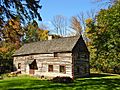
Shelter House in Emmaus, constructed in 1734 by Pennsylvania German settlers, is believed to be the oldest continuously occupied building structure in both Lehigh County and the Lehigh Valley and among the oldest still-standing building structures in Pennsylvania.
-
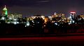
The city skyline of center city Allentown, Lehigh County's largest city, Christmas 2017
-
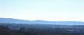
South Mountain, part of the Appalachian Mountain range in Lehigh County, with Allentown in the foreground, December 2010
-
Baum School of Art in Allentown, January 2009
-
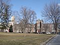
Cedar Crest College in Allentown, March 2014
-
Muhlenberg College in Allentown March 2014
-
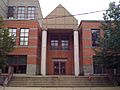
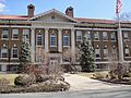
Allen High School, one of Allentown's two large public high schools, July 2008
-
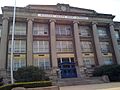
Salisbury High School in Salisbury Township, June 2015
-
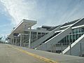
Lehigh Valley International Airport, Pennsylvania's fourth busiest airport, in Hanover Township in Lehigh County, March 2014
-
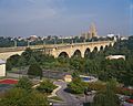
Albertus L. Meyers Bridge crossing the Little Lehigh River in Allentown in Lehigh County, May 2007
-
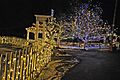
Christmas lights at Lehigh Valley Zoo in Schnecksville, December 2020
-
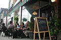
Young people gather on 19th Street in Allentown's West End, July 2007
-
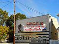
The historic Emmaus Theatre on South Fourth Street in Emmaus, October 2012
-
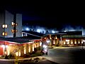
Bear Creek Mountain Resort in Longswamp Township, January 2012
-
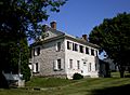
The George Taylor House in Catasauqua, home of George Taylor, a founding father of the United States who signed the Declaration of Independence, August 2008
-
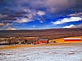
A farm in Lynn Township in the northwest corner of Lehigh County, February 2008


.JPG)


.JPG)


See also
 In Spanish: Condado de Lehigh para niños
