
Lexington, South Carolina facts for kids
Quick facts for kids
Lexington, South Carolina
|
|
|---|---|
 |
|
| Motto(s):
"Town of Progress"
|
|

Lexington, South Carolina
Location in South Carolina

Lexington, South Carolina
Location in the United States
|
|
| Country | |
| State | |
| County | Lexington County |
| Government | |
| • Type | Mayor-Council |
| • Body | Lexington Town Council |
| Area | |
| • Total | 11.98 sq mi (31.04 km2) |
| • Land | 11.84 sq mi (30.66 km2) |
| • Water | 0.14 sq mi (0.38 km2) |
| Elevation | 394 ft (120 m) |
| Population
(2010)
|
|
| • Total | 17,870 |
| • Estimate
(2019)
|
22,157 |
| • Rank | 23rd |
| • Density | 1,871.68/sq mi (722.66/km2) |
| Time zone | UTC−5 (Eastern (EST)) |
| • Summer (DST) | UTC−4 (EDT) |
| ZIP codes |
29071, 29072, 29073
|
| Area code(s) | 803, 839 |
| FIPS code | 45-41335 |
| GNIS feature ID | 1246349 |
Lexington is the largest town in and the county seat of Lexington County, South Carolina, United States. It is a suburb of the state capital, Columbia. The population was 17,870 at the 2010 Census, and it is the second-largest municipality in the greater Columbia area. The 2019 estimated population is 22,157. According to the Central Midlands Council of Governments, the greater Lexington area had an estimated population of 111,549 in 2020 and is considered the fastest-growing area in the Midlands. Lexington's town limits are bordered to the east by the city of West Columbia.
Contents
History
In 1735, the colonial government of King George II established eleven townships in backcountry South Carolina, to encourage settlement, and to provide a buffer between Native American tribes to the West and colonial plantations in the Lowcountry. The townships included one named Saxe Gotha, which flourished with major crops of corn, wheat, tobacco, hemp, and flax, as well as beeswax and livestock.
The Battle of Tarrar Springs was fought nearby on November 16, 1781. In 1785, Saxe Gotha was replaced with Lexington County, in commemoration of the Battles of Lexington and Concord in Massachusetts. The county's first courthouse was built in Granby, but chronic flooding forced the courthouse to move in 1820 to its present location, establishing the community of Lexington Courthouse. The community was incorporated as the Town of Lexington in 1861.
In 1865 Union Army forces destroyed the courthouse and many buildings in the town. But local farms and the lumber industry helped stabilize the economy after Reconstruction. The town grew due to the Columbia to Augusta Railroad and the Lexington Textile Mill, constructed in 1890.
Many current brick buildings were built in the aftermath of severe fires in 1894 and 1916.
The Move Over Law, a law that requires drivers to change lanes when there is a stopped emergency vehicle on the side of the road, originated in Lexington, SC, after a South Carolina Paramedic, James D. Garcia, was struck and injured at an accident scene on Jan. 28, 1994. Garcia was listed at fault, leading to his work to create this law. SC's version (SC 56-5-1538) passed in 1996, and was revised in 2002.
A Murphy Express gas station on Augusta Highway in Lexington, SC sold a $400 million winning Powerball ticket on September 18, 2013. This ticket was the fifth largest winning ticket of any United States lottery.
On November 5, 2013, incumbent Lexington mayor Randy Halfacre lost a reelection bid to Councilman Steve MacDougall by only 18 votes. A recount was initiated but the results remained the same.
Buildings listed on the National Register of Historic Places. include:
- The Ballentine-Shealy House
- Bank of Western Carolina
- W. Q. M. Berly House
- William Berly House
- Lemuel Boozer House
- C.E. Corley House
- Fox House
- Gunter-Summers House
- James Harman Building
- Ernest L. Hazelius House
- John Solomon Hendrix House
- John Jacob Hite Farm
- Home National Bank,
- Lexington County Courthouse
- Henry Lybrand Farm
- Maj. Henry A. Meetze House
- Old Batesburg-Leesville High School
- Charlton Rauch House
- David Rawl House
- Simmons-Harth House
- James Stewart House
- Vastine Wessinger House

Geography
Lexington is located at 33°58′52″N 81°13′51″W / 33.98111°N 81.23083°W (33.980975, -81.230839).
According to the United States Census Bureau, the town has a total area of 8.8 square miles (23 km2), of which 8.7 square miles (23 km2) is land and 0.1 square miles (0.26 km2) (1.73%) is water.
Lexington is 12 mi (19 km) away from South Carolina's state capital and largest city, Columbia.
Climate
The lowest recorded temperature in Lexington was −2 °F (−19 °C) in February 1899. The warmest recorded temperature was 111 °F (44 °C) in June 2012. July averages the most yearly precipitation. Lexington averages 48 in (1.2 m) of rain per year; Lexington averages 4 in (10 cm) of snow per year.
| Climate data for Columbia, South Carolina (Columbia Airport), 1981–2010 normals | |||||||||||||
|---|---|---|---|---|---|---|---|---|---|---|---|---|---|
| Month | Jan | Feb | Mar | Apr | May | Jun | Jul | Aug | Sep | Oct | Nov | Dec | Year |
| Record high °F (°C) | 84 (29) |
84 (29) |
93 (34) |
96 (36) |
101 (38) |
107 (42) |
109 (43) |
107 (42) |
106 (41) |
101 (38) |
90 (32) |
83 (28) |
109 (43) |
| Average high °F (°C) | 56.0 (13.3) |
61 (16) |
68 (20) |
76 (24) |
84 (29) |
90 (32) |
93 (34) |
91 (33) |
85 (29) |
76 (24) |
67 (19) |
58 (14) |
75 (24) |
| Average low °F (°C) | 30 (−1) |
33 (1) |
41 (5) |
50 (10) |
60 (16) |
68 (20) |
72 (22) |
71 (22) |
64 (18) |
52 (11) |
42 (6) |
32 (0) |
51 (11) |
| Record low °F (°C) | −1 (−18) |
−4 (−20) |
4 (−16) |
26 (−3) |
34 (1) |
44 (7) |
54 (12) |
53 (12) |
40 (4) |
23 (−5) |
12 (−11) |
4 (−16) |
−4 (−20) |
| Average precipitation inches (mm) | 3.58 (91) |
3.74 (95) |
3.73 (95) |
2.62 (67) |
2.97 (75) |
4.69 (119) |
5.46 (139) |
5.26 (134) |
3.54 (90) |
3.17 (81) |
2.74 (70) |
3.22 (82) |
44.56 (1,132) |
| Average snowfall inches (cm) | 0.1 (0.25) |
0.8 (2.0) |
0.1 (0.25) |
0 (0) |
0 (0) |
0 (0) |
0 (0) |
0 (0) |
0 (0) |
0 (0) |
0 (0) |
0.1 (0.25) |
1.6 (4.1) |
| Average precipitation days (≥ 0.01 in) | 9.9 | 9.1 | 8.6 | 8.0 | 7.7 | 10.5 | 11.8 | 10.5 | 7.3 | 7.0 | 7.3 | 9.0 | 106.8 |
| Average snowy days (≥ 0.1 in) | 0.5 | 0.3 | 0.1 | 0 | 0 | 0 | 0 | 0 | 0 | 0 | 0 | 0.1 | 1.0 |
| Mean monthly sunshine hours | 173.6 | 183.6 | 238.7 | 270.0 | 291.4 | 279.0 | 285.2 | 263.5 | 240.0 | 235.6 | 195.0 | 173.6 | 2,829.2 |
| Source: NOAA (extremes 1887–present), | |||||||||||||
Transportation
Public transportation
Public transportation in Lexington is provided by the COMET, or officially the Central Midlands Regional Transit Authority (CMRTA). The bus system is the main public transit system for the greater Columbia area.
Roads and highways
Interstate highways
 I-20 – Interstate 20 travels from west to east and connects Columbia to Atlanta and Augusta in the west and Florence in the east. It serves the nearby towns and suburbs of West Columbia, Oak Grove, and Red Bank.
U.S. routes
 U.S. 1
 U.S. 378
S.C. highways
 SC 6
SC 6
Sights

Slightly north of the relatively affluent town of Lexington rests one of South Carolina's major lakes, Lake Murray. The lake is held by a 1.7 mile long dam which people are free to drive, bike, run, or walk across. The Saluda Dam, or Lake Murray Dam, provides electricity for the surrounding area and is a beacon for the Midlands of South Carolina. There is also a public swimming area that is open during the summer months on the Lexington side of the dam.
Demographics
| Historical population | |||
|---|---|---|---|
| Census | Pop. | %± | |
| 1880 | 262 | — | |
| 1890 | 342 | 30.5% | |
| 1900 | 806 | 135.7% | |
| 1910 | 709 | −12.0% | |
| 1920 | 894 | 26.1% | |
| 1930 | 1,152 | 28.9% | |
| 1940 | 1,033 | −10.3% | |
| 1950 | 1,081 | 4.6% | |
| 1960 | 1,127 | 4.3% | |
| 1970 | 969 | −14.0% | |
| 1980 | 2,131 | 119.9% | |
| 1990 | 3,289 | 54.3% | |
| 2000 | 9,793 | 197.8% | |
| 2010 | 17,870 | 82.5% | |
| 2019 (est.) | 22,157 | 24.0% | |
| U.S. Decennial Census | |||
2020 census
| Race | Num. | Perc. |
|---|---|---|
| White (non-Hispanic) | 16,841 | 71.46% |
| Black or African American (non-Hispanic) | 2,666 | 11.31% |
| Native American | 49 | 0.21% |
| Asian | 1,581 | 6.71% |
| Pacific Islander | 23 | 0.1% |
| Other/Mixed | 1,005 | 4.26% |
| Hispanic or Latino | 1,403 | 5.95% |
As of the 2020 United States census, there were 23,568 people, 7,907 households, and 5,270 families residing in the town.
2010 census
As of the census of 2010, there were 17,870 people, 8,101 households, and 2,558 families residing in the town. The population density was 1,724.4 inhabitants per square mile (665.8/km2). There were 4,025 housing units at an average density of 708.7/sq mi (273.6/km2). Since 2000, the town population grew from nearly 10,000 inhabitants to 25,000, a 166% increase. Since 2005, 3,200 new homes have been built within the town limits, as well as 130 new businesses.
In the 2010 census, the racial makeup of the town was 83.88% White, 12.48% Black or African American, 0.18% Native American, 2.05% Asian, 0.03% Pacific Islander, 0.67% from other races, and 0.70% from two or more races. Hispanic or Latino of any race were 1.91% of the population.
There were 3,644 households, out of which 40.5% had children under the age of 18 living with them, 55.9% were married couples living together, 12.3% had a female householder with no husband present, and 29.8% were non-families. 24.9% of all households were made up of individuals, and 7.5% had someone living alone who was 65 years of age or older. The average household size was 2.51 and the average family size was 3.03.
In the town, the population was spread out, with 27.1% under the age of 18, 7.5% from 18 to 24, 39.6% from 25 to 44, 18.3% from 45 to 64, and 7.5% who were 65 years of age or older. The median age was 33 years. For every 100 females, there were 97.6 males. For every 100 females age 18 and over, there were 96.3 males.
The median income for a household in the town was $53,865, and the median income for a family was $65,694. Males had a median income of $44,883 versus $29,020 for females. The per capita income for the town was $23,416. About 5.2% of families and 7.2% of the population were below the poverty line, including 7.3% of those under age 18 and 14.5% of those age 65 or over.
Neighboring Towns and Cities
This is a list of municipalities within 15 miles of the town center of Lexington, SC:
- Springdale (East 7.5 miles)
- Irmo (North 8 miles)
- South Congaree (Southeast 8.5 miles)
- Pine Ridge (Southeast 9 miles)
- Cayce (East 9.5 miles)
- West Columbia (East 9.5 miles)
- Columbia (East 12 miles)
- Summit (West 12 miles)
- Gilbert (West 12.5 miles)
- Chapin (Northwest 14.5 miles)
Economy
In 2019, the unemployment rate was 1.7%, and the per capita personal income was $31,900. According to the Town's 2020 Comprehensive Annual Financial Report, the top employers in the city are:
| # | Employer | # of Employees |
|---|---|---|
| 1 | Lexington School District 1 | 1,083 |
| 2 | Lexington County | 905 |
| 3 | Walmart | 367 |
| 4 | Town of Lexington | 180 |
| 5 | Publix | 160 |
| 6 | Lowe's | 150 |
| 7 | Home Depot | 150 |
| 8 | Avtec | 135 |
| 9 | Target | 120 |
| 10 | Kohl's | 107 |
Education
Public education in Lexington is administered by Lexington County School District One, which has an enrollment of over 27,000 students and employees 3,900 faculty and staff.
| Elementary schools | Enrollment | Within town limits? |
|---|---|---|
| Pleasant Hill Elementary School | 948 | No |
| Midway Elementary School | 947 | No |
| Meadow Glen Elementary School | 908 | Yes |
| Carolina Springs Elementary School | 800 | No |
| Lake Murray Elementary School | 759 | No |
| Saxe Gotha Elementary School | 752 | No |
| Rocky Creek Elementary | 730 | No |
| Deerfield Elementary School | 723 | No |
| Oak Grove Elementary School | 715 | No |
| White Knoll Elementary | 711 | No |
| New Providence Elementary School | 672 | Yes |
| Lexington Elementary School | 644 | Yes |
| Red Bank Elementary School | 579 | No |
| Middle schools | Enrollment | Within town limits? |
| Pleasant Hill Middle School | 1,208 | No |
| Meadow Glen Middle School | 1,029 | Yes |
| Lexington Middle School | 992 | Yes |
| Carolina Springs Middle | 930 | No |
| Beechwood Middle School | 850 | No |
| White Knoll Middle School | 787 | No |
| High schools | Enrollment | Within town limits? |
| Lexington High School | 2,105 | No |
| River Bluff High School | 2,047 | Yes |
| White Knoll High School | 1,955 | No |
| Lexington Technology Center | No | |
| Adult education | Enrollment | Within town limits? |
| Rosenwald Community Learning Center | 100 | Yes |
Library
Lexington has a branch of the Lexington County Library.
Notable people
- Nick Ciuffo, 2013 first-round pick by the Tampa Bay Rays
- Manuel S. Corley, congressman (1868-1869)
- Nikki Haley, former United States Ambassador to the United Nations and 116th governor of South Carolina
- Lacie Lybrand, Miss South Carolina USA 2006
- Bob Peeler, former lieutenant governor (1995–2003), trustee of Clemson University
- Shaq Roland, former South Carolina Gamecocks and West Georgia Wolves wide receiver, and former member of the Chicago Bears practice squad
- Floyd Spence, congressman from 1970 to 2001 and resident of Lexington while in office
- Demetris Summers, former Canadian football running back for the Calgary Stampeders
- Harold E. Wilson, Marine in Korean War; awarded Congressional Medal of Honor
Images for kids
-

Lexington, SC Main Street (1916)
-
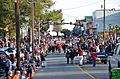
Lexington 2019 Christmas Parade
-

Welcome Sign, Lexington, SC off of Highway 378
-
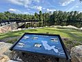
Gipson Pond -- Lexington, SC
-
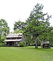
The Ballentine-Shealy House c. 1870.
-
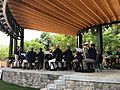
Lexington, SC community band playing at the Icehouse Amphitheater
-

The Lexington Community Band performs "The Star-Spangled Banner" at the opening of a Blowfish baseball game.


See also
 In Spanish: Lexington (Carolina del Sur) para niños
