Lexington, Virginia facts for kids
Quick facts for kids
Lexington, Virginia
|
|
|---|---|

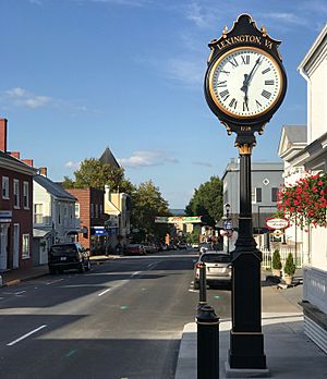
Main Street, Lexington
|
|
| Country | United States |
| State | Virginia |
| County | None (Independent city) |
| Area | |
| • Total | 2.52 sq mi (6.54 km2) |
| • Land | 2.50 sq mi (6.47 km2) |
| • Water | 0.03 sq mi (0.07 km2) |
| Elevation | 1,063 ft (324 m) |
| Population
(2020)
|
|
| • Total | 7,320 |
| • Density | 2,905/sq mi (1,119.3/km2) |
| Time zone | UTC−5 (Eastern (EST)) |
| • Summer (DST) | UTC−4 (EDT) |
| ZIP code |
24450
|
| Area code(s) | 540 |
| FIPS code | 51-45512 |
| GNIS feature ID | 1498506 |
| Website | Lexington, Virginia |
Lexington is an independent city in the Commonwealth of Virginia in the United States. At the 2020 census, the population was 7,320. It is the county seat of Rockbridge County, although the two are separate jurisdictions. The Bureau of Economic Analysis combines the city of Lexington (along with nearby Buena Vista) with Rockbridge County for statistical purposes. Lexington is about 57 miles (92 km) east of the West Virginia border and is about 50 miles (80 km) north of Roanoke, Virginia. It was first settled in 1778.
Lexington is the location of the Virginia Military Institute (VMI) and of Washington and Lee University (W&L).
Contents
City Council
| Official | Position |
|---|---|
| Frank Friedman | Mayor |
| Marylin E. Alexander | Councilwoman |
| Leslie Straughan | Councilwoman |
| Michele Hentz | Councilwoman |
| J. Patrick Rhamey, Jr. | Councilman |
| David Sigler | Councilman |
| Charles "Chuck" Smith | Councilman |
History
Lexington was named in 1778. It was one of the first of what would be many American places named after Lexington, Massachusetts, known for being the place at which the first shot was fired in the American Revolution.
The Union General David Hunter led a raid on Virginia Military Institute during the American Civil War. Robert E. Lee and Stonewall Jackson are buried here. It is the site of the only house Jackson ever owned, now open to the public as a museum. Cyrus McCormick invented the horse-drawn mechanical reaper at his family's farm in Rockbridge County and a statue of McCormick is located on the Washington and Lee University campus. McCormick Farm is now owned by Virginia Tech and is a satellite agricultural research center.
Geography
According to the United States Census Bureau, the city has a total area of 2.5 square miles (6.5 km2), virtually all of which is land. The Maury River, a tributary of the James River, forms the city's northeastern boundary.
Climate
The climate in this area is characterized by hot, humid summers and generally mild to cool winters. According to the Köppen climate classification system, Lexington has a humid subtropical climate, similar to Northern Italy, abbreviated "Cfa" on climate maps.
Demographics
| Historical population | |||
|---|---|---|---|
| Census | Pop. | %± | |
| 1850 | 1,743 | — | |
| 1860 | 2,135 | 22.5% | |
| 1870 | 2,873 | 34.6% | |
| 1880 | 2,771 | −3.6% | |
| 1890 | 3,059 | 10.4% | |
| 1900 | 3,203 | 4.7% | |
| 1910 | 2,931 | −8.5% | |
| 1920 | 2,870 | −2.1% | |
| 1930 | 3,752 | 30.7% | |
| 1940 | 3,914 | 4.3% | |
| 1950 | 5,976 | 52.7% | |
| 1960 | 7,537 | 26.1% | |
| 1970 | 7,597 | 0.8% | |
| 1980 | 7,292 | −4.0% | |
| 1990 | 6,959 | −4.6% | |
| 2000 | 6,867 | −1.3% | |
| 2010 | 7,042 | 2.5% | |
| 2020 | 7,320 | 3.9% | |
| U.S. Decennial Census 1790–1960 1900–1990 1990–2000 2010 2020 |
|||
2020 census
| Race / Ethnicity | Pop 2010 | Pop 2020 | % 2010 | % 2020 |
|---|---|---|---|---|
| White alone (NH) | 5,807 | 6,015 | 82.46% | 82.17% |
| Black or African American alone (NH) | 668 | 454 | 9.49% | 6.20% |
| Native American or Alaska Native alone (NH) | 8 | 8 | 0.11% | 0.11% |
| Asian alone (NH) | 153 | 281 | 2.17% | 3.84% |
| Pacific Islander alone (NH) | 4 | 0 | 0.06% | 0.00% |
| Some Other Race alone (NH) | 12 | 23 | 0.17% | 0.31% |
| Mixed Race/Multi-Racial (NH) | 119 | 204 | 1.69% | 2.79% |
| Hispanic or Latino (any race) | 271 | 335 | 3.85% | 4.58% |
| Total | 7,042 | 7,320 | 100.00% | 100.00% |
Note: the US Census treats Hispanic/Latino as an ethnic category. This table excludes Latinos from the racial categories and assigns them to a separate category. Hispanics/Latinos can be of any race.
Points of interest
- George C. Marshall Foundation
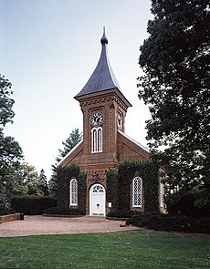
- Robert E. Lee grave site, found in Lee Chapel on the W&L campus.
- Traveller (Lee's horse) grave site, found along a walkway just outside Lee Chapel.
- Stonewall Jackson grave site, found at Stonewall Jackson Memorial Cemetery
- Sam Houston place of birth (nearby)
- Cyrus McCormick Farm, birthplace and museum (nearby)
- Kappa Alpha Order international headquarters
- Omicron Delta Kappa national headquarters
- Sigma Nu international headquarters
- Boxerwood Gardens
- Chessie Nature Trail follows the former C&O railway bed along the Maury River
- Natural Bridge (nearby)
- Hull's Drive In, the first non-profit drive-in theatre in the U.S. (nearby)
- Gems of the Rockbridge geocaching trail
- Located near Lexington are a number of properties listed on the National Register of Historic Places, including: Anderson Hollow Archaeological District, Cedar Hill Church and Cemeteries, Chapel Hill, Church Hill, Clifton, Hamilton Schoolhouse, Liberty Hall Site, Lylburn Downing School, Maple Hall, John Moore House, Mountain View Farm, Margaret E. Poague House, Springdale, Stone House, Sunnyside, Tankersley Tavern, Thorn Hill, Timber Ridge Presbyterian Church, and Willson House.
- Lexington Carriage Company
Economy
Today, Lexington's primary economic activities stem from higher education and tourism. With its various connections to the Civil War, Lexington attracts visitors from around the country. Places of interest in Lexington include the Stonewall Jackson House, Lee Chapel, the George C. Marshall Museum, Virginia Military Institute Museum, Museum of Military Memorabilia, and the downtown historic district. Hull's Drive In theater attracts visitors to the area and was the first community-owned, non-profit drive-in in the U.S.
Lexington also contains a host of small retail businesses, bed and breakfast inns, and restaurants catering to a unique mixture of local, tourist, and collegiate clientele. The historic R. E. Lee Hotel, built in the 1920s, underwent extensive renovation and re-opened its doors late 2014.
Transportation
Lexington is located at the intersection of historic U.S. Route 11 and U.S. Route 60 and more modern highways, Interstate 64 and Interstate 81. RADAR Transit operates the Maury Express, which provides local bus service to Lexington and Buena Vista. The Virginia Breeze provides intercity bus service between Blacksburg and Washington, D.C., with a stop in Lexington.
Notable people
- William H. Armstrong, children's author and educator best known for his 1969 novel Sounder, which won the Newbery Medal.
- Baroness (band), American heavy metal band whose members grew up together in Lexington.
- Howard Drew, competitor in the 1912 Summer Olympics.
- Kelly Evans, journalist and co-presenter for CNBC.
- Hilary Hahn, classical violinist.
- Larry Keel, bandleader and musician.
- John Letcher, 34th Governor of Virginia.
- William Lindsay, U.S. Senator from Kentucky.
- William A. MacCorkle, ninth Governor of West Virginia.
- Sally Mann, photographer.
- Gary W. Martini, posthumously awarded the Medal of Honor for his actions in the Vietnam War.
- William G. McDowell, Episcopal prelate who served as the fifth Bishop of Alabama.
- Robert Paxton, political scientist and historian.
- William N. Pendleton, Confederate general, longtime artillery adviser to General Lee.
- John Thomas Lewis Preston, founder of Virginia Military Institute.
- Pat Robertson, founder and chairman of Christian Broadcasting Network.
- Cy Twombly, artist.
- Reginald H. Ridgely Jr., United States Marine Corps lieutenant general; born in Lexington.
See also
 In Spanish: Lexington (Virginia) para niños


