
Liberal, Kansas facts for kids
Quick facts for kids
Liberal, Kansas
|
||
|---|---|---|
|
City and county seat
|
||
      From left to right, clockwise: A welcome sign on U.S. Route 83, the Baker Arts Center, the Pioneer Mother of Kansas statue, the Liberal Chamber of Commerce office, the First Baptist Church of Liberal, the Seward County Courthouse.
|
||
|
||
| Motto(s):
"Crossroads of Commerce"
|
||

Location within Seward County and Kansas
|
||

|
||
| Country | United States | |
| State | Kansas | |
| County | Seward | |
| Founded | 1888 | |
| Incorporated | 1888 | |
| Area | ||
| • Total | 11.65 sq mi (30.18 km2) | |
| • Land | 11.43 sq mi (29.60 km2) | |
| • Water | 0.22 sq mi (0.57 km2) | |
| Elevation | 2,835 ft (864 m) | |
| Population
(2020)
|
||
| • Total | 19,825 | |
| • Density | 1,701.7/sq mi (656.89/km2) | |
| Time zone | UTC-6 (CST) | |
| • Summer (DST) | UTC-5 (CDT) | |
| ZIP codes |
67901, 67905
|
|
| Area code | 620 | |
| FIPS code | 20-39825 | |
| GNIS ID | 470667 | |
Liberal is the county seat of Seward County, Kansas, United States. As of the 2020 census, the population of the city was 19,825. Liberal is home of Seward County Community College.
Contents
History
Early settler S. S. Rogers built the first house in what would become Liberal in 1872. Rogers became famous in the region for giving water to weary travelers. Reportedly, Liberal gained its name from the common response to his acts of kindness, "That's very liberal of you." In 1885 Rogers built a general store, and with it came an official U.S. Post Office. Rogers named the post office 'Liberal'. After the railroad was built close by, a plan for the town site was created in 1888. A year later the population was around 800.
Drought caused some farmers to give up and look for more fertile territory; however, when the nearby Indian Territory was opened, more settlers headed to the cheap land that would become Oklahoma.
Natural gas was discovered west of town, in what would become part of the massive Panhandle-Hugoton Gas Field, in 1920. Oil was discovered southwest of town in 1951. In 1963 the largest helium plant in the world, National Helium, was opened.
Geography
Liberal is located at 37°2′36″N 100°55′41″W / 37.04333°N 100.92806°W (37.043418, −100.928133) at an elevation of 2,835 feet (864 m). Located in southwestern Kansas at the intersection of U.S. Route 83 and U.S. Route 54, Liberal is 140 miles (225 km) north-northeast of Amarillo, Texas, 202 mi (325 km) west-southwest of Wichita, and 288 mi (463 km) southeast of Denver, Colorado.
The city lies approximately 10 miles (16 km) southwest of the Cimarron River in the High Plains region of the Great Plains.
According to the United States Census Bureau, the city has a total area of 11.75 square miles (30.43 km2), of which 11.61 square miles (30.07 km2) is land and 0.14 square miles (0.36 km2) is water.
Climate
Liberal has a semi-arid steppe climate (Köppen BSk) characterized by hot, dry summers, cool, dry winters, and large diurnal temperature variation year-round; relative humidity averages 63%. On average, January is the coldest month, July is the hottest month, and June is the wettest month.
The monthly daily average temperature ranges from 34.1 °F (1.2 °C) in January to 79.3 °F (26.3 °C) in July. The high temperature reaches or exceeds 90 °F (32 °C) an average of 80 days a year and 100 °F (38 °C) an average of 18 days. The minimum temperature falls to or below 0 °F (−17.8 °C) on an average 5.3 days a year. The highest temperature recorded in Liberal was 114 °F (45.6 °C) as recently as June 10, 1981; the coldest temperature recorded was −19 °F (−28.3 °C) on January 7, 1912.
On average, Liberal receives 20.15 inches (512 mm) of precipitation annually, a majority of which occurs from May to August, and records 58 days of measurable precipitation. Measurable snowfall occurs an average of 8.9 days per year with 6.1 days receiving at least 1.0 inch (2.5 cm). Snow depth of at least one inch occurs an average of 9.5 days a year. Typically, the average window for freezing temperatures is October 21 through April 14, and that for temperatures below 0 °F or −17.8 °C from January 5 to January 24. Liberal is located in USDA Plant Hardiness Zone 7.
| Climate data for Liberal, Kansas | |||||||||||||
|---|---|---|---|---|---|---|---|---|---|---|---|---|---|
| Month | Jan | Feb | Mar | Apr | May | Jun | Jul | Aug | Sep | Oct | Nov | Dec | Year |
| Record high °F (°C) | 85 (29) |
87 (31) |
93 (34) |
103 (39) |
106 (41) |
114 (46) |
113 (45) |
111 (44) |
108 (42) |
99 (37) |
88 (31) |
85 (29) |
114 (46) |
| Average high °F (°C) | 47.7 (8.7) |
51.3 (10.7) |
60.2 (15.7) |
69.9 (21.1) |
78.9 (26.1) |
88.2 (31.2) |
93.5 (34.2) |
92.0 (33.3) |
84.0 (28.9) |
71.7 (22.1) |
58.5 (14.7) |
47.3 (8.5) |
70.3 (21.3) |
| Daily mean °F (°C) | 34.1 (1.2) |
37.3 (2.9) |
45.4 (7.4) |
54.7 (12.6) |
64.7 (18.2) |
74.1 (23.4) |
79.3 (26.3) |
78.2 (25.7) |
69.6 (20.9) |
57.0 (13.9) |
44.1 (6.7) |
34.3 (1.3) |
56.1 (13.4) |
| Average low °F (°C) | 20.4 (−6.4) |
23.4 (−4.8) |
30.6 (−0.8) |
39.6 (4.2) |
50.4 (10.2) |
60.1 (15.6) |
65.1 (18.4) |
64.3 (17.9) |
55.1 (12.8) |
42.4 (5.8) |
29.7 (−1.3) |
21.3 (−5.9) |
41.9 (5.5) |
| Record low °F (°C) | −19 (−28) |
−13 (−25) |
−12 (−24) |
10 (−12) |
20 (−7) |
38 (3) |
48 (9) |
40 (4) |
29 (−2) |
10 (−12) |
−2 (−19) |
−13 (−25) |
−19 (−28) |
| Average precipitation inches (mm) | 0.45 (11) |
0.65 (17) |
1.34 (34) |
1.69 (43) |
2.69 (68) |
3.01 (76) |
2.97 (75) |
2.23 (57) |
1.83 (46) |
1.91 (49) |
0.78 (20) |
0.70 (18) |
20.25 (514) |
| Average snowfall inches (cm) | 3.6 (9.1) |
3.2 (8.1) |
4.6 (12) |
0.9 (2.3) |
0 (0) |
0 (0) |
0 (0) |
0 (0) |
0.1 (0.25) |
0.5 (1.3) |
1.1 (2.8) |
5.1 (13) |
19.1 (48.85) |
| Average precipitation days (≥ 0.01 in) | 2.4 | 3.0 | 4.6 | 5.0 | 6.8 | 7.6 | 7.0 | 6.3 | 4.8 | 4.3 | 3.0 | 3.3 | 58.1 |
| Average snowy days (≥ 0.1 in) | 2.1 | 1.7 | 1.6 | 0.3 | 0 | 0 | 0 | 0 | 0 | 0.2 | 0.8 | 2.3 | 9 |
| Average relative humidity (%) | 75 | 71 | 62 | 67 | 59 | 58 | 58 | 54 | 55 | 61 | 58 | 73 | 63 |
| Source: National Weather Service; Weatherbase | |||||||||||||
Demographics
| Historical population | |||
|---|---|---|---|
| Census | Pop. | %± | |
| 1900 | 426 | — | |
| 1910 | 1,716 | 302.8% | |
| 1920 | 3,613 | 110.5% | |
| 1930 | 5,294 | 46.5% | |
| 1940 | 4,410 | −16.7% | |
| 1950 | 7,134 | 61.8% | |
| 1960 | 13,813 | 93.6% | |
| 1970 | 13,862 | 0.4% | |
| 1980 | 14,911 | 7.6% | |
| 1990 | 16,573 | 11.1% | |
| 2000 | 19,666 | 18.7% | |
| 2010 | 20,525 | 4.4% | |
| 2020 | 19,825 | −3.4% | |
| U.S. Decennial Census 2010-2020 |
|||
2010 census
As of the 2010 census, there were 20,525 people, 6,623 households, and 4,838 families residing in the city. The population density was 1,832.6 people per square mile (707.6/km2). There were 7,118 housing units at an average density of 641.3 per square mile (248.9/km2). The racial makeup of the city was 68.6% White, 3.7% African American, 2.9% Asian, 0.8% American Indian, 0.2% Pacific Islander, 20.6% from other races, and 3.2% from two or more races. Hispanics and Latinos of any race made up 58.7% of the population.
There were 6,623 households, of which 42.3% had children under the age of 18 living with them, 52.7% were married couples living together, 7.1% had a male householder with no wife present, 13.2% had a female householder with no husband present, and 27.0% were non-families. 21.7% of all households were made up of individuals, and 7.5% had someone living alone who was 65 years of age or older. The average household size was 3.03, and the average family size was 3.54.
The median age was 28.4 years. 32.1% of residents were under the age of 18; 12.4% were between the ages of 18 and 24; 27.8% were from 25 to 44; 19.4% were from 45 to 64; and 8.3% were 65 years of age or older. The gender makeup of the city population was 51.4% male and 48.6% female.
The median income for a household in the city was $40,247, and the median income for a family was $44,167. Males had a median income of $31,435 versus $25,208 for females. The per capita income for the city was $17,668. About 15.3% of families and 17.8% of the population were below the poverty line, including 23.6% of those under age 18 and 8.2% of those age 65 or over.
Transportation
U.S. Route 83 runs north-south along the east side of the city, intersecting U.S. Route 54 which runs northeast-southwest. In addition, Liberal is the western terminus of U.S. Route 270 which runs concurrently with U.S. 83 south from the city.
Liberal Mid-America Regional Airport is immediately west of the city. Publicly owned, it has two operative paved runways and is used primarily for general aviation. United Express provides airline service with daily flights to Denver.
The Tucumcari Line of the Union Pacific Railroad runs parallel to U.S. 54 northeast-southwest through the city.
Culture
Events
Liberal is famous for its annual Pancake Day race that is held in competition with the town of Olney, England for the fastest time between both cities.
Points of interest

Liberal has a water park known as Adventure Bay.
The fifth largest collection of civilian and military aircraft in the United States is located at the Mid-America Air Museum. Started with a gift of fifty planes by General Tom (Thomas) Welch, Jr., the museum has more than one hundred aircraft.
The Coronado Museum has items from the Native Americans that lived in the area, as well as items from Francisco Vásquez de Coronado's expedition to the area in 1541, and the history of farming and ranching in the county in more recent times.
Liberal is home to "The Land of Oz" exhibit from The Wizard of Oz, a recreation of Dorothy Gale's house and the famed Yellow Brick Road, featuring donated bricks bearing the names of such luminaries as former U.S. Senator Bob Dole, Ronald and Nancy Reagan, and Liza Minnelli (Judy Garland's daughter). This exhibit was originally designed and displayed for Topeka in 1981, but relocated here eleven years later by its creator Linda Windler.
Liberal Memorial Library is located on North Kansas Avenue between Fifth and Sixth Streets in Cooper Park. The Book Front entrance was completed in April 1955 and designed by the building's architect George L. Pitcher. Wheeler Williams, a sculptor from New York, signed an agreement in October 1960 to mold the "Pioneer Mother of Kansas." This six foot statue, sponsored by Mr. and Mrs. D. K. Baty, was to be erected in Cooper Park on Memorial Day, May 30, 1961. It was placed opposite of the "Statue of Liberty," which was donated and placed in Cooper Park by the Boy Scouts of America.
Sports
The Liberal Bee Jays, a semi-professional baseball team, have won five national championships and 13 state championships. The Bee Jays have been coached by three major league managers and have sent 165 players to the major leagues.
In popular culture and the arts
Composer Mark So wrote his LIBERAL PLAIN SONG (for Joseph Kudirka) while stopped at a gas station in Liberal in 2005. [1]
In the movie National Lampoon's Vacation, Clark W. Griswold mentions departing the route of travel to Liberal to see the world's largest house of mud. The idea is rejected by his wife, Ellen, in favor of getting to her cousin Eddie's home.
Gallery
-
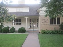
Baker Arts Center (2010)
-
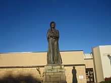
The Pioneer Mother of Kansas statue (2010)
-
Liberal Chamber of Commerce office (2010)
-
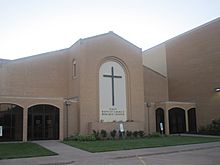
First Baptist Church of Liberal (2010)
-
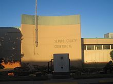
Seward County Courthouse (2010)
- History of the State of Kansas; William G. Cutler; A.T. Andreas Publisher; 1883. (Online HTML eBook)
- Kansas : A Cyclopedia of State History, Embracing Events, Institutions, Industries, Counties, Cities, Towns, Prominent Persons, Etc.; 3 Volumes; Frank W. Blackmar; Standard Publishing Co; 944 / 955 / 824 pages; 1912. (Volume1 - Download 54MB PDF eBook),(Volume2 - Download 53MB PDF eBook), (Volume3 - Download 33MB PDF eBook)
- City
- Schools
- Maps
Economy

Energy and agriculture are the main economic drivers of the area. Natural resources include oil, natural gas, water, gravel and sand. The beef industry (ranches, feed lots and packing plants) is Liberal's largest source of employment. Hard winter wheat, corn, milo, alfalfa and cotton are common crops. Trucking is a major industry. Dairies and pork processors are a growing business.
As of 2012[update], 70.2% of the population over the age of 16 was in the labor force. 0.0% was in the armed forces, and 70.2% was in the civilian labor force with 63.4% being employed and 6.9% unemployed. The composition, by occupation, of the employed civilian labor force was: 28.5% in production, transportation, and material moving; 20.0% in natural resources, construction, and maintenance; 19.9% in sales and office occupations; 18.9% in management, business, science, and arts; and 12.6% in service occupations. The three industries employing the largest percentages of the working civilian labor force were: manufacturing (24.4%); educational services, health care, and social assistance (19.4%); and retail trade (10.5%).
The cost of living in Liberal is relatively low; compared to a U.S. average of 100, the cost of living index for the city is 80.8. As of 2012[update], the median home value in the city was $85,600, the median selected monthly owner cost was $961 for housing units with a mortgage and $383 for those without, and the median gross rent was $648.
Top employers
According to Liberal's 2011 Comprehensive Annual Financial Report, the top 10 employers in the city are:
| # | Employer | Employees |
|---|---|---|
| 1 | National Beef Packing Company | 3,500 |
| 2 | Liberal USD 480 | 800 |
| 3 | Seward County Community College | 450 |
| 4 | Southwest Medical Center | 425 |
| 5 | Walmart Stores | 350 |
| 6 | Seaboard Foods | 275 |
| 7 | Seward County | 200 |
| 8 | City of Liberal | 200 |
| 9 | National Carriers | 200 |
| 10 | Panhandle Oilfield Services | 175 |
Education
Colleges
- Seward County Community College
Primary and secondary
The community is served by Liberal USD 480 public school district, which operates twelve schools in the city:
|
|
There is also a Christian school in Liberal: Fellowship Baptist School (K–12).
Notable people
Notable individuals who were born in and/or have lived in Liberal include:
|
|
See also
 In Spanish: Liberal (Kansas) para niños
