Liberty County, Florida facts for kids
Quick facts for kids
Liberty County
|
|
|---|---|

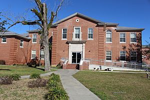
Liberty County Courthouse
|
|

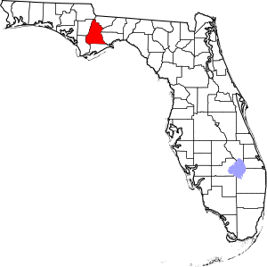
Location within the U.S. state of Florida
|
|
 Florida's location within the U.S. |
|
| Country | |
| State | |
| Founded | December 15, 1855 |
| Seat | Bristol |
| Largest city | Bristol |
| Area | |
| • Total | 843 sq mi (2,180 km2) |
| • Land | 836 sq mi (2,170 km2) |
| • Water | 7.6 sq mi (20 km2) 0.9%% |
| Population | |
| • Estimate
(2019)
|
8,354 |
| • Density | 10/sq mi (4/km2) |
| Time zone | UTC−5 (Eastern) |
| • Summer (DST) | UTC−4 (EDT) |
| Congressional district | 2nd |
Liberty County is a county located in the state of Florida. As of the 2010 census, the population was 8,365, making it the least populous county in Florida. Its county seat is Bristol.
The Apalachicola National Forest occupies half the county.
Contents
History
Liberty County was created in 1855 and is named after the popular American ideal of liberty.
Geography
According to the U.S. Census Bureau, the county has a total area of 843 square miles (2,180 km2), of which 836 square miles (2,170 km2) is land and 7.6 square miles (20 km2) (0.9%) is water. The county is bordered on the west by the Apalachicola River.
Adjacent counties
- Gadsden County - northeast
- Wakulla County - east
- Leon County - east
- Franklin County - south
- Gulf County - southwest
- Calhoun County - west
- Jackson County - northwest
National protected area
- Apalachicola National Forest (part)
Demographics
| Historical population | |||
|---|---|---|---|
| Census | Pop. | %± | |
| 1860 | 1,457 | — | |
| 1870 | 1,050 | −27.9% | |
| 1880 | 1,362 | 29.7% | |
| 1890 | 1,452 | 6.6% | |
| 1900 | 2,956 | 103.6% | |
| 1910 | 4,700 | 59.0% | |
| 1920 | 5,006 | 6.5% | |
| 1930 | 4,067 | −18.8% | |
| 1940 | 3,752 | −7.7% | |
| 1950 | 3,182 | −15.2% | |
| 1960 | 3,138 | −1.4% | |
| 1970 | 3,379 | 7.7% | |
| 1980 | 4,260 | 26.1% | |
| 1990 | 5,569 | 30.7% | |
| 2000 | 7,021 | 26.1% | |
| 2010 | 8,365 | 19.1% | |
| 2019 (est.) | 8,354 | −0.1% | |
| U.S. Decennial Census 1790-1960 1900-1990 1990-2000 2010-2019 |
|||
As of the census of 2000, there were 7,021 people, 2,222 households, and 1,553 families residing in the county. The population density was 8 people per square mile (3/km2). There were 3,156 housing units at an average density of 4 per square mile (1/km2). The racial makeup of the county was 76.41% White, 18.43% Black or African American, 1.81% Native American, 0.14% Asian, 2.08% from other races, and 1.13% from two or more races. 4.50% of the population were Hispanic or Latino of any race. More than 10% of the population are Mormons.
There were 2,222 households, out of which 34.20% had children under the age of 18 living with them, 51.80% were married couples living together, 13.20% had a female householder with no husband present, and 30.10% were non-families. 25.90% of all households were made up of individuals, and 10.60% had someone living alone who was 65 years of age or older. The average household size was 2.51 and the average family size was 3.00.
In the county, the population was spread out, with 21.80% under the age of 18, 9.40% from 18 to 24, 37.70% from 25 to 44, 21.00% from 45 to 64, and 10.20% who were 65 years of age or older. The median age was 35 years. For every 100 females there were 144.90 males. For every 100 females age 18 and over, there were 159.50 males.
The median income for a household in the county was $28,840, and the median income for a family was $34,244. Males had a median income of $22,078 versus $22,661 for females. The per capita income for the county was $17,225. About 16.80% of families and 19.90% of the population were below the poverty line, including 24.30% of those under age 18 and 24.30% of those age 65 or over.
Library
Liberty County is part of the Northwest Regional Library System (NWRLS), which serves Gulf and Bay Counties as well.
Communities
City
Census-designated places
Unincorporated communities
- Estiffanulga
- New York
- Orange
- Rock Bluff
- Telogia
- White Springs
- Wilma
- Woods
Transportation
Much like Calhoun County, Liberty County has no Interstates or U.S. Highways, just state roads.
 FL State Road 20 is the main west-to-east route that runs east from the Apalachicola River at the Calhoun/Liberty County line to the Ochlockonee River at the Liberty/Leon County line, passing through Bristol and Hosford.
 FL State Road 65 is the main south-to-north route running from the Franklin/Liberty County line at Sumatra to the Liberty/Gadsden County line north of Hosford.
 FL State Road 12 is a southwest-to-southeast route running from Liberty County in the southwest to Havana in the northeast. It also contains a county extension into Levy County.
 FL State Road 267 briefly runs alongside state road 20 until it splits away shortly after crossing the Leon/Liberty county line and heads north towards Quincy.
See also
 In Spanish: Condado de Liberty (Florida) para niños

