
Liberty County, Georgia facts for kids
Quick facts for kids
Liberty County
|
|
|---|---|

Liberty County Courthouse in Hinesville
|
|

Location within the U.S. state of Georgia
|
|
 Georgia's location within the U.S. |
|
| Country | |
| State | |
| Founded | February 5, 1777 |
| Seat | Hinesville |
| Largest city | Hinesville |
| Area | |
| • Total | 603 sq mi (1,560 km2) |
| • Land | 490 sq mi (1,300 km2) |
| • Water | 113 sq mi (290 km2) 18.7%% |
| Population | |
| • Estimate
(2019)
|
61,435 |
| • Density | 130/sq mi (50/km2) |
| Time zone | UTC−5 (Eastern) |
| • Summer (DST) | UTC−4 (EDT) |
| Congressional district | 1st |
Liberty County is a county in the U.S. state of Georgia. As of the 2020 census, the population is 65,256. The county seat is Hinesville.
Liberty County is part of the Hinesville, Georgia Metropolitan Statistical Area, which is also included in the Savannah-Hinesville-Statesboro, Georgia Combined Statistical Area.
Contents
History
Liberty county was established in 1777. It is named for the popular American ideal of liberty. Sunbury was first designated the county seat in 1784. In 1797, the seat was transferred to Riceboro and in 1837 it was transferred again to Hinesville.
Geography
According to the U.S. Census Bureau, the county has a total area of 603 square miles (1,560 km2), of which 490 square miles (1,300 km2) is land and 113 square miles (290 km2) (18.7%) is water.
The eastern and southern portion of Liberty County is located in the Ogeechee Coastal sub-basin of the Ogeechee River basin. The northern and western portion of the county is located in the Canoochee River sub-basin of the Ogeechee River basin.
Major highways
 Interstate 95
 U.S. Route 17
 U.S. Route 84
 State Route 25
 State Route 38
 State Route 38 Connector
 State Route 119
 State Route 144
 State Route 196
 State Route 405 (unsigned designation for I-95)
Adjacent counties
- Chatham County - northeast
- Bryan County - north
- McIntosh County - south
- Long County - west
- Evans County - northwest
- Tattnall County - northwest
Demographics
| Historical population | |||
|---|---|---|---|
| Census | Pop. | %± | |
| 1790 | 5,355 | — | |
| 1800 | 5,313 | −0.8% | |
| 1810 | 6,228 | 17.2% | |
| 1820 | 6,695 | 7.5% | |
| 1830 | 7,233 | 8.0% | |
| 1840 | 7,241 | 0.1% | |
| 1850 | 7,926 | 9.5% | |
| 1860 | 8,367 | 5.6% | |
| 1870 | 7,688 | −8.1% | |
| 1880 | 10,649 | 38.5% | |
| 1890 | 12,887 | 21.0% | |
| 1900 | 13,093 | 1.6% | |
| 1910 | 12,924 | −1.3% | |
| 1920 | 12,707 | −1.7% | |
| 1930 | 8,153 | −35.8% | |
| 1940 | 8,595 | 5.4% | |
| 1950 | 8,444 | −1.8% | |
| 1960 | 14,487 | 71.6% | |
| 1970 | 17,569 | 21.3% | |
| 1980 | 37,583 | 113.9% | |
| 1990 | 52,745 | 40.3% | |
| 2000 | 61,610 | 16.8% | |
| 2010 | 63,453 | 3.0% | |
| 2020 | 65,256 | 2.8% | |
| U.S. Decennial Census 1790-1960 1900-1990 1990-2000 2010-2013 |
|||
2010 census
At the 2010 census, there were 63,453 people, 22,155 households, and 16,566 families living in the county. The population density was 129.5 inhabitants per square mile (50.0/km2). There were 26,731 housing units at an average density of 54.6 per square mile (21.1/km2). The racial makeup of the county was 47.1% white, 42.2% black or African American, 2.0% Asian, 0.6% Pacific islander, 0.6% American Indian, 2.9% from other races, and 4.7% from two or more races. Those of Hispanic or Latino origin made up 9.7% of the population. In terms of ancestry, 8.8% were German, 6.9% were Irish, and 6.0% were American.
Of the 22,155 households, 45.9% had children under the age of 18 living with them, 49.0% were married couples living together, 21.5% had a female householder with no husband present, 25.2% were non-families, and 20.7% of households were made up of individuals. The average household size was 2.75 and the average family size was 3.18. The median age was 27.9 years.
The median household income was $42,674 and the median family income was $46,818. Males had a median income of $35,881 versus $31,159 for females. The per capita income for the county was $18,662. About 15.0% of families and 17.8% of the population were below the poverty line, including 26.2% of those under age 18 and 13.4% of those age 65 or over.
2020 census
| Race | Num. | Perc. |
|---|---|---|
| White (non-Hispanic) | 24,004 | 36.78% |
| Black or African American (non-Hispanic) | 27,309 | 41.85% |
| Native American | 225 | 0.34% |
| Asian | 1,325 | 2.03% |
| Pacific Islander | 437 | 0.67% |
| Other/Mixed | 4,170 | 6.39% |
| Hispanic or Latino | 7,786 | 11.93% |
As of the 2020 United States census, there were 65,256 people, 23,485 households, and 16,657 families residing in the county.
Communities
Cities
Census-designated place
Unincorporated community
- Sunbury
In the media
The 2014 award-winning Independent film, A Promise, was filmed in Liberty County.
Education

Liberty County School District operates public schools, including the comprehensive high school Liberty County High School and the Bradwell Institute, as well as its educative middle schools Midway Middle School, Lewis Frasier Middle School, and Snelson-Golden Middle School.
They also provide a career academy, Liberty College & Career Academy (LCCA), for extra academics where students study for a profession they could seek out in the future.
Images for kids
-
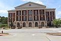
Liberty County Justice Center
-
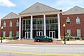
Liberty County Courthouse Annex
-
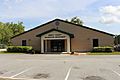
Liberty County Recreation Department


See also
 In Spanish: Condado de Liberty (Georgia) para niños
