
Lindfield, New South Wales facts for kids
Quick facts for kids LindfieldSydney, New South Wales |
|||||||||||||||
|---|---|---|---|---|---|---|---|---|---|---|---|---|---|---|---|
_04.jpg)
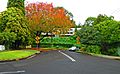
Waimea Road
|
|||||||||||||||
| Population | 9,791 (2016 census) | ||||||||||||||
| • Density | 1,893.8/km2 (4,905/sq mi) | ||||||||||||||
| Established | 1815 | ||||||||||||||
| Postcode(s) | 2070 | ||||||||||||||
| Area | 5.17 km2 (2.0 sq mi) | ||||||||||||||
| Location | 13 km (8 mi) north-west of Sydney CBD | ||||||||||||||
| LGA(s) | Ku-ring-gai Council | ||||||||||||||
| State electorate(s) |
|
||||||||||||||
| Federal Division(s) | Bradfield | ||||||||||||||
|
|||||||||||||||
Lindfield is a suburb on the Upper North Shore of Sydney in the state of New South Wales, Australia. It is 13 kilometres north-west of the Sydney Central Business District and is in the local government area of Ku-ring-gai Council. East Lindfield is a separate suburb, although they share the postcode of 2070.
This suburb of 5.17 square kilometres contains residential housing of California bungalow and federation style, in double brick and tile construction. Australian native bushland in Garigal National Park and Lane Cove National Park borders the suburb.
Contents
History
Lindfield was originally the home of the Kuringgai indigenous people.
Europeans first became active in the area in around 1810, when the colonial government set up a timber gathering camp staffed by convicts. By the 1840s, fruit growing and farming became the suburb's primary industries. Settlement began to increase in the latter half of the eighteenth century. The Lindfield railway station opened in 1890, and Lindfield Post Office opened on 5 January 1895. Land values increased in the area around the railway and more professionals moved into the area.
The name "Lindfield" means a clearing in the lime forest, and derives from the name given by an early landowner, Francis List, to a cottage he built in the area in 1884. List likely named his cottage after Lindfield, Sussex, England. When a railway line came through the area in 1890s, the name of the property was used to identify the station and neighbourhood.
During the years after World War II the suburb experienced significant growth.
Double Town Centre
- Coles
- IGA (reopens late 2017)
- Harris Farm (opens late 2017)
- 2 Chinese Restaurants (Chan's and West Lindfield)
- KFC
- Subway
Infrastructure and development

Lindfield railway station is on the North Shore & Western Line of the Sydney Trains network and is about 30 minutes by train from the Sydney central business district. The Pacific Highway is the main arterial road through Lindfield. Lindfield has a small commercial area on both sides of Lindfield railway station on the Pacific Highway and Lindfield Avenue. The former Commonwealth Bank is an art deco style building on the Pacific Highway.
Lindfield Library is a branch of the Ku-ring-gai Municipal Library Network. There are two community halls: East Lindfield Community Hall at Crana Avenue and West Lindfield Community Hall at Moore Avenue. There are two tennis courts at Lindfield Community Centre (behind the library) and a further two courts at Lindfield Park in Tryon Road.
Places of worship
Lindfield has five places of worship: St Albans Anglican Church, Holy Family Catholic Church, Lindfield Uniting Church (with church buildings on Tryon Road and the Pacific Highway) and the North Shore Synagogue.
Schools
Schools in the suburb comprise: Lindfield Public School, Lindfield East Public School, Newington College Preparatory School, Holy Family Catholic Primary School, and Masada College (K-6). Killara High School is also close by, in Killara.
The University of Technology, Sydney, Kuring-gai Campus, (formerly The William Balmain Teachers College and then The Kuring-gai College Of Advanced Education,) operated at a campus on Eton Road from 1971 to 2015. It offered courses in business, nursing and midwifery, education and travel. The site was then closed in 2015 while an extensive interior fitout was undertaken. It was reopened ahead of the 2019 school year as The Lindfield Learning Village, an unconventional K-12 public school.
Commercial
Commercial developments in Lindfield are situated along the Pacific Highway, Lindfield Shopping Village and nearby Tryon Road.
Lindfield Arcade was demolished in 2016 in order to facilitate the construction of residential apartments.
-
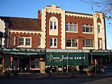
Lindfield Avenue shops
-
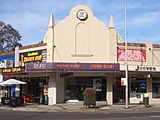
Pacific Highway shops
-
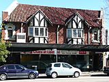
Pacific Highway Tudor revival building
-
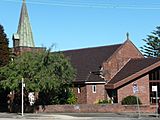
Lindfield Uniting Church


Residential
-
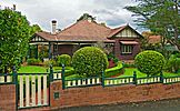
Federation House, Trafalgar Avenue
-
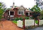
Federation house, Strickland Avenue
-
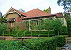
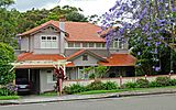
Federation house, Middle Harbour Road
-
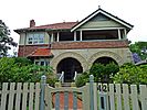
Federation house, Nelson Road
-
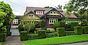
California bungalow house, Northcote Road
-
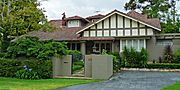
Arts & Crafts Bungalow house, Waimea Road
-
Arts & Crafts Bungalow House, Northcote Road
-
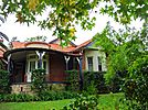
Federation home, Waimea Road
.jpg)
.jpg)
.jpg)
_01.jpg)
.jpg)
.jpg)
.jpg)
.jpg)
Images for kids
-
Strickland Avenue
_02.jpg)
