
Lindsay, Oklahoma facts for kids
Quick facts for kids
Lindsay, Oklahoma
|
|
|---|---|
| Motto(s):
"Working hard as a community"
|
|

Location of Lindsay, Oklahoma
|
|
| Country | United States |
| State | Oklahoma |
| County | Garvin |
| Area | |
| • Total | 2.36 sq mi (6.12 km2) |
| • Land | 2.36 sq mi (6.11 km2) |
| • Water | 0.01 sq mi (0.02 km2) |
| Elevation | 974 ft (297 m) |
| Population
(2010)
|
|
| • Total | 2,840 |
| • Estimate
(2019)
|
2,777 |
| • Density | 1,177.69/sq mi (454.76/km2) |
| Time zone | UTC-6 (Central (CST)) |
| • Summer (DST) | UTC-5 (CDT) |
| ZIP code |
73052
|
| Area code(s) | 405 |
| FIPS code | 40-43150 |
| GNIS feature ID | 1094691 |
Lindsay is a city in Garvin County, Oklahoma, United States. The population was 2,840 at the 2010 census. It once promoted itself as "The Broomcorn Capital of the World" but no longer uses that slogan, as broomcorn is no longer raised in the area.
History
Lindsay was founded in January 1902, when the Atchison, Topeka and Santa Fe and the Chicago, Rock Island and Pacific railroad companies linked their lines halfway between Chickasha and Pauls Valley. Lindsay was named after Lewis Lindsay, a local area farmer who donated 440 acres (180 ha) of land for the townsite.
-
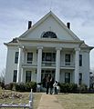
The Lindsay-Murray Mansion

Geography
Lindsay is located in northwestern Garvin County at 34°50′14″N 97°36′27″W / 34.83722°N 97.60750°W (34.837280, -97.607537). The town's northern border follows the McClain County line.
Lindsay is in the Washita River valley. Oklahoma State Highway 19 passes through the center of town as Cherokee Street, leading east (downriver) 11 miles (18 km) to Maysville and northwest (generally upstream) 28 miles (45 km) to Chickasha. Oklahoma State Highway 76 leads north from Lindsay 23 miles (37 km) to Blanchard and south 46 miles (74 km) Healdton.
According to the United States Census Bureau, Lindsay has a total area of 2.3 square miles (6.0 km2), of which 0.01 square miles (0.02 km2), or 0.25%, is water.
Climate
| Climate data for Lindsay, Oklahoma | |||||||||||||
|---|---|---|---|---|---|---|---|---|---|---|---|---|---|
| Month | Jan | Feb | Mar | Apr | May | Jun | Jul | Aug | Sep | Oct | Nov | Dec | Year |
| Average high °F (°C) | 51.0 (10.6) |
56.6 (13.7) |
66.4 (19.1) |
75.8 (24.3) |
82.4 (28.0) |
89.4 (31.9) |
95.6 (35.3) |
95.1 (35.1) |
86.4 (30.2) |
76.8 (24.9) |
63.9 (17.7) |
53.6 (12.0) |
74.4 (23.6) |
| Average low °F (°C) | 25.3 (−3.7) |
30.0 (−1.1) |
39.0 (3.9) |
49.1 (9.5) |
57.6 (14.2) |
65.5 (18.6) |
69.8 (21.0) |
68.1 (20.1) |
60.9 (16.1) |
49.9 (9.9) |
38.6 (3.7) |
28.8 (−1.8) |
48.6 (9.2) |
| Average precipitation inches (mm) | 1.3 (33) |
1.8 (46) |
2.9 (74) |
3.4 (86) |
5.4 (140) |
4.0 (100) |
2.1 (53) |
2.4 (61) |
4.3 (110) |
3.7 (94) |
2.2 (56) |
1.7 (43) |
35.1 (890) |
| Source 1: weather.com | |||||||||||||
| Source 2: Weatherbase.com | |||||||||||||
Demographics
| Historical population | |||
|---|---|---|---|
| Census | Pop. | %± | |
| 1910 | 1,156 | — | |
| 1920 | 1,543 | 33.5% | |
| 1930 | 1,713 | 11.0% | |
| 1940 | 1,792 | 4.6% | |
| 1950 | 3,021 | 68.6% | |
| 1960 | 4,258 | 40.9% | |
| 1970 | 3,705 | −13.0% | |
| 1980 | 3,454 | −6.8% | |
| 1990 | 2,947 | −14.7% | |
| 2000 | 2,889 | −2.0% | |
| 2010 | 2,840 | −1.7% | |
| 2019 (est.) | 2,777 | −2.2% | |
| U.S. Decennial Census | |||
As of the census of 2000, there were 2,889 people, 1,244 households, and 794 families residing in the city. The population density was 1,231.9 people per square mile (474.7/km2). There were 1,446 housing units at an average density of 616.6 per square mile (237.6/km2). The racial makeup of the city was 90.86% White, 0.14% African American, 4.92% Native American, 0.10% Asian, 0.03% Pacific Islander, 0.76% from other races, and 3.18% from two or more races. Hispanic or Latino of any race were 1.25% of the population.
There were 1,244 households, out of which 27.3% had children under the age of 18 living with them, 52.1% were married couples living together, 9.4% had a female householder with no husband present, and 36.1% were non-families. 34.5% of all households were made up of individuals, and 21.7% had someone living alone who was 65 years of age or older. The average household size was 2.28 and the average family size was 2.91.
In the city, the population was spread out, with 23.3% under the age of 18, 8.5% from 18 to 24, 24.1% from 25 to 44, 19.1% from 45 to 64, and 25.0% who were 65 years of age or older. The median age was 40 years. For every 100 females, there were 81.8 males. For every 100 females age 18 and over, there were 78.1 males.
The median income for a household in the city was $26,667, and the median income for a family was $35,208. Males had a median income of $26,831 versus $18,207 for females. The per capita income for the city was $14,320. About 9.9% of families and 15.6% of the population were below the poverty line, including 19.4% of those under age 18 and 12.5% of those age 65 or over.
Economy
In Lindsay, the oilfield industry is a major source of revenue and jobs.
Education
Lindsay Public Schools provide schooling from kindergarten through high school.
Transportation
Lindsay is at the intersection of Oklahoma State Highway 76 and Oklahoma State Highway 19. The intersection of SH-59B with SH-19 is just east of town, which leads to Oklahoma State Highway 59.
The city is served by Lindsay Municipal Airport northeast of town.
See also
 In Spanish: Lindsay (Oklahoma) para niños
