Lindum Colonia facts for kids
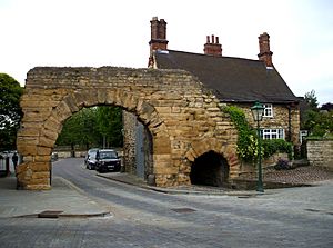
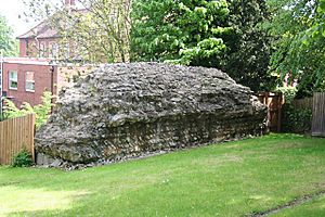
The Newport Arch is a surviving part of the north gate to the Upper City.
|
|
| Alternative name | Lindum, Colonia Domitiana Lindensium |
|---|---|
| Location | Lincoln, Lincolnshire, England |
| Region | Britannia |
| Coordinates | 53°14′02″N 00°32′17″W / 53.23389°N 0.53806°W |
| Type | Settlement |
| History | |
| Builder | Domitian |
| Founded | Around 80 AD |
| Abandoned | End of the 5th century |
| Periods | Roman Imperial |
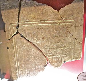
Lindum Colonia was the Latin name for the settlement which is now the City of Lincoln in Lincolnshire. It was founded as a Roman Legionary Fortress during the reign of the Emperor Nero (58–68 AD) or possibly later. Evidence from Roman tombstones suggests that Lincoln was first garrisoned by the Ninth Legion Hispana, which probably moved from Lincoln to found the fortress at York around c. 71 AD. Lindum was then garrisoned by the Second Legion Adiutrix, which then went on to Chester in 77–78 AD.
Probably under the reign of Domitian and most likely after 86 AD, the fortress became a colonia, a settlement for retired soldiers sanctioned by the Emperor. The colonia now developed and a second enclosure, often referred to as the Lower Colonia was added between the Upper Colonia and the River Witham. Evidence has been uncovered for the Forum, baths, temples, buildings and shops of the colonia which was enclosed by walls. The walls of the Upper Colonia started to be built in the earlier part of the 2nd century, while the Lower Colonia was walled in either the late 2nd or early 3rd centuries. The Roman settlement also spread to the south of the river Witham in the area known as the Wigford. In the early 3rd century with the re-organisation of the Roman Empire, a case can be made that Lindum Colonia had become the provincial capital of Britannia Secunda and possibly a Bishop from Lincoln was present at the Council of Arles in 314 AD. In the 4th century Lincoln continued to develop and there is increasing evidence for Christianity. After the departure of the Romans in the 5th century Lindum declined in size and population, although archaeological evidence suggests some degree of continuity.
Contents
Name
The name is a Latinized form of a native Brittonic name which has been reconstructed as *Lindon (lit. "pool" or "lake"; cf. modern Welsh llyn). The primary evidence that modern Lincoln was referred to as Lindum comes from Ptolemy's Geography, which was compiled in about 150 AD, where Lindum is referred to as a polis or town within the tribal area of the Corieltauvi. In the Antonine Itinerary, a road book of the mid-2nd century AD, Lindum is mentioned three times as Lindo in the Iter or routes numbered V, VI and VIII. Then, in the Ravenna Cosmography, a listing of towns in the Roman Empire compiled in the 7th century AD, Lincoln is referred to as Lindum Colonia. As the Roman colonia for veteran soldiers at Lincoln is thought to have been established during the reign of the Roman Emperor Domitian (81–96), it has been suggested that the full name of the colonia would have been Colonia Domitiana Lindensium, but, as yet, there have been no Roman inscriptions found that confirm this.
History
Construction
The Romans conquered this part of Britain in AD 48 and shortly afterwards built a legionary fortress, possibly south of the River Witham. This was soon replaced, around the year 60, by a second fort for the Ninth Legion, high on a hill overlooking the natural lake formed by the widening of the River Witham (the modern day Brayford Pool) and at the northern end of the Fosse Way Roman road. That pool is very likely to have given Lincoln its name.
Decline and transformation
The city and its waterways eventually fell into decline, and, by the end of the 5th century, it was virtually deserted. However, the church of St Paul continued as a place of worship until at least 450 and its churchyard was in use into the 6th century. When Saint Paulinus visited in 629, it was apparently under the control of a Praefectus Civitatis called Blecca. Archaeological evidence indicates that a timber apsidal church was probably built either in the 5th or 6th century in the centre of the old forum. This church was large enough to hold around 100 worshippers, challenging the idea that Lincoln was nearly deserted. Instead, it fits with other evidence for Lincoln retaining its central position in the post-Roman polity called *Lindēs, which became the Kingdom of Lindsey in the Anglo-Saxon period.
Planning, infrastructure, trade and religion
The Roman aqueduct or water supply
Roman Lincoln had a very sophisticated water supply. It was fed by the ‘‘Roaring Meg’’ spring to the North East of the city and then ran parallel with the Nettleham Road towards the N.E corner of the Upper Colonia. The ceramic pipes were encased in concrete that provided a waterproof seal and allowed the water to pass through the pipes under pressure. The course of the aqueduct had been well known from the start of the 18th century. William Stukeley had shown the line of the aqueduct on his plan of Lincoln in 1722. The Lincoln antiquary Thomas Sympson had written in the mid 18th century "There must have been some contrivance for raising the water a good deal above its natural level before it would run to Lindum; the spring being evidently lower than the Town: and indeed there are some traces of a Tower, or some such building at the end of the Aquaeduct by the Spring, which one may suppose would have had a reservoir on its Top." In 1782 the artist Samuel Hieronymus Grimm drew sections of the sheathed pipe and also where it emerged from the ground at the spring. Over the years further lengths of the aqueduct have been uncovered and the base for a watertank fed by the aqueduct discovered just inside the Roman Wall to the east of the Newport Arch. This is just to the north of Cottesford Place, where excavations in the 1960s revealed a probable Roma Bathhouse, which could have been supplied with water from this source. Another pipeline, encased in concrete was found in 1857 by the Greestone Stairs, to the east of the wall, and this pipeline had presumably branched off from the aqueduct and supplied water to the Lower Colonia. Thompson calculated that it would be necessary to raise the water about 70 feet at the source at the ‘‘Roaring Meg’’ for there to be sufficient pressure for the water to reach the tank at the East Bight by the Newport Arch. This may imply that there was some form of water tower and the Romans may either have used some form of pump to raise the water, or a revolving bucket and chain system.
Before 2007 it was questioned whether the Roman aqueduct at Lincoln had ever worked as there was no evidence of limescale in any of the lengths of pipe that had been uncovered. Construction on a housing estate close to the Nettleham showed that there was limescale , indicating that the aqueduct had been in use. This length of the aqueduct had ceramic pipes, joined with collared joints , but other lengths of the aqueduct had pipes which were about 7.5 inches in diameter, narrowing to 4 inches and when laid, the narrow or spigot end of the pipe fitted into the broad or socket end of the next pipe.
Industry
Pottery production
Lincoln was an important centre for pottery production. The earliest discovery of a pottery kiln was on the site of the Technical College (now Lincoln College) on Monks Road. This kiln produced Mortaria stamped with the maker's name VITALIS. who was probably working around 90-115 AD. A further discovery was made in 1947 when Graham Webster excavated a kiln site producing gray ware storage jars at Swanpool, to the S.W. of Lincoln. This was followed in 1950 by the excavation of further mortaria kilns found on the Lincoln Racecourse by Phillip Corder. Kilns producing mortaria by a potter called CATTO and also colour painted and rosette decorated pottery are known from South Carlton, to the north of Lincoln. In the 3rd and 4th centuries, Lincolnshire produced a coarse ware ceramic known as Dales ware, which was exported across the north of Roman Britain.
Roman sculpture and tombstones
|
See also
 In Spanish: Lindum Colonia para niños


