Linn County, Iowa facts for kids
Quick facts for kids
Linn County
|
|||
|---|---|---|---|

|
|||
|
|||

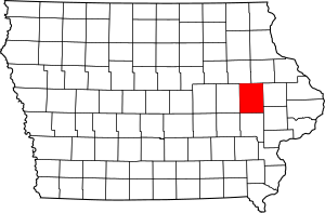
Location within the U.S. state of Iowa
|
|||
 Iowa's location within the U.S. |
|||
| Country | |||
| State | |||
| Founded | 1839 | ||
| Named for | Lewis Linn | ||
| Seat | Cedar Rapids | ||
| Largest city | Cedar Rapids | ||
| Area | |||
| • Total | 725 sq mi (1,880 km2) | ||
| • Land | 717 sq mi (1,860 km2) | ||
| • Water | 7.6 sq mi (20 km2) 1.1% | ||
| Population
(2020)
|
|||
| • Total | 230,299 | ||
| • Density | 317.65/sq mi (122.65/km2) | ||
| Time zone | UTC−6 (Central) | ||
| • Summer (DST) | UTC−5 (CDT) | ||
| Congressional district | 1st | ||
Linn County is a county located in the U.S. state of Iowa. As of the 2020 census, the population was 230,299, making it the second-most populous county in Iowa. The county seat is Cedar Rapids. Linn County is named in honor of Senator Lewis F. Linn of Missouri. Linn County is included in the Cedar Rapids, IA Metropolitan Statistical Area.
Contents
History
Linn County was created as a named but unorganized area on December 21, 1837, as a part of Wisconsin Territory. It became part of Iowa Territory on July 4, 1838 when the territory was organized. Linn County was organized by the first legislative assembly of the Iowa Territory on January 15, 1839. A site was selected for its first county seat along Indian Creek, and was named Marion, after the Revolutionary War general Francis Marion. As early as 1855, there were debates over moving the county seat to the fast-growing Cedar Rapids, southwest of Marion, but it was not until November 6, 1919, that there were enough votes in favor of the move (9,960 to 4,823). The first rail line was built through Cedar Rapids in 1859, and made the town (and the county) a major commercial hub in eastern Iowa.
Many areas of the county were damaged by the flooding of Cedar River in June 2008.
Geography
According to the U.S. Census Bureau, the county has a total area of 725 square miles (1,880 km2), of which 717 square miles (1,860 km2) is land and 7.6 square miles (20 km2) (1.1%) is water.
Major highways
 Interstate 380
 Iowa Highway 27
 U.S. Highway 30
 U.S. Highway 151
 U.S. Highway 218
 Iowa Highway 1
 Iowa Highway 13
Adjacent counties
- Benton County (west)
- Buchanan County (northwest)
- Cedar County (southeast)
- Delaware County (northeast)
- Iowa County (southwest)
- Johnson County (south)
- Jones County (east)
Demographics
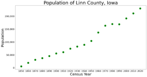
| Historical population | |||
|---|---|---|---|
| Census | Pop. | %± | |
| 1850 | 5,444 | — | |
| 1860 | 18,947 | 248.0% | |
| 1870 | 31,080 | 64.0% | |
| 1880 | 37,237 | 19.8% | |
| 1890 | 45,303 | 21.7% | |
| 1900 | 55,392 | 22.3% | |
| 1910 | 60,720 | 9.6% | |
| 1920 | 74,004 | 21.9% | |
| 1930 | 82,336 | 11.3% | |
| 1940 | 89,142 | 8.3% | |
| 1950 | 104,274 | 17.0% | |
| 1960 | 136,899 | 31.3% | |
| 1970 | 163,213 | 19.2% | |
| 1980 | 169,775 | 4.0% | |
| 1990 | 168,767 | −0.6% | |
| 2000 | 191,701 | 13.6% | |
| 2010 | 211,226 | 10.2% | |
| 2020 | 230,299 | 9.0% | |
| U.S. Decennial Census 1790–1960 1900–1990 1990–2000 2010–2019 |
|||
2020 census
The 2020 census recorded a population of 230,299 in the county, with a population density of 317.2724/sq mi (122.4996/km2). 94.04% of the population reported being of one race. 78.91% were non-Hispanic White, 7.14% were Black, 3.87% were Hispanic, 0.24% were Native American, 2.33% were Asian, 0.23% were Native Hawaiian or Pacific Islander and 7.28% were some other race or more than one race. There were 101,230 housing units, of which 94,751 were occupied.
2010 census
The 2010 census recorded a population of 211,226 in the county, with a population density of 294.4163/sq mi (113.6748/km2). There were 92,251 housing units, of which 86,134 were occupied.
Communities
Cities
Unincorporated communities
Ghost towns
Townships
- Bertram
- Boulder
- Brown
- Buffalo
- Clinton
- College
- Fairfax
- Fayette
- Franklin
- Grant
- Jackson
- Linn
- Maine
- Marion
- Monroe
- Otter Creek
- Putnam
- Spring Grove
- Washington
Population ranking
The population ranking of the following table is based on the 2010 census of Linn County.
† county seat
| Rank | City/Town/etc. | Municipal type | Population (2010 Census) |
|---|---|---|---|
| 1 | † Cedar Rapids | City | 126,326 |
| 2 | Marion | City | 34,768 |
| 3 | Hiawatha | City | 7,024 |
| 4 | Mount Vernon | City | 4,506 |
| 5 | Robins | City | 3,142 |
| 6 | Center Point | City | 2,421 |
| 7 | Lisbon | City | 2,152 |
| 8 | Fairfax | City | 2,123 |
| 9 | Ely | City | 1,776 |
| 10 | Walford (partially in Benton County) | City | 1,463 |
| 11 | Central City | City | 1,257 |
| 12 | Springville | City | 1,074 |
| 13 | Palo | City | 1,026 |
| 14 | Walker | City | 791 |
| 15 | Alburnett | City | 673 |
| 16 | Coggon | City | 658 |
| 17 | Bertram | City | 294 |
| 18 | Prairieburg | City | 178 |
See also
 In Spanish: Condado de Linn (Iowa) para niños


