| Name |
Image |
Refs |
Dedication |
Founded |
Denomination |
Location |
Notes |
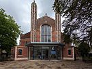
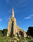
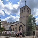
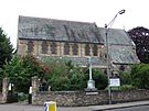
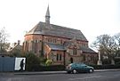
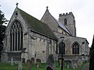
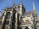
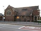
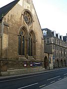
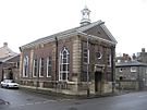
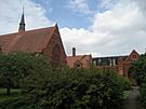
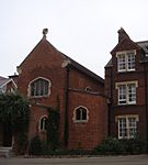
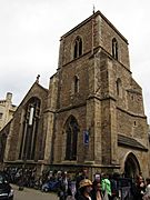
| Christ Church |
 |
|
Jesus |
1837-1839 |
Church of England |
52°12′28″N 0°08′00″E / 52.2078°N 0.1332°E / 52.2078; 0.1332 (Christ Church) |
Received a church graft from St Andrew the Great 2004 |
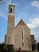
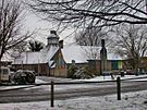
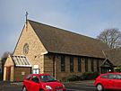
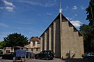
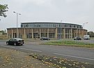
| Christ the Redeemer |
|
|
Jesus |
|
Church of England/
Methodist |
52°12′43″N 0°09′53″E / 52.2119°N 0.1647°E / 52.2119; 0.1647 (Christ the Redeemer) |
2004 merger of Meadowlands Methodist Church (founded in or before 1953) and Holy Cross, Fen Ditton |
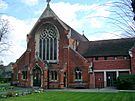
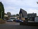
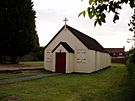
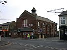
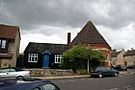
| The Good Shepherd |
 |
|
Jesus |
1958 |
Church of England |
52°13′31″N 0°07′35″E / 52.2254°N 0.1264°E / 52.2254; 0.1264 (The Good Shepherd) |
|
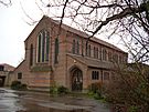
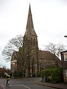
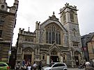
| Holy Trinity |
 |
|
Trinity |
1189 |
Church of England |
52°12′21″N 0°07′13″E / 52.2059°N 0.1203°E / 52.2059; 0.1203 (Holy Trinity) |
|
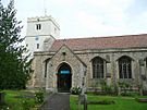
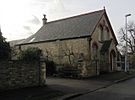
| St Andrew's, Cherry Hinton |
 |
|
Andrew |
c. 1200 |
Church of England |
52°11′31″N 0°10′41″E / 52.1919°N 0.1781°E / 52.1919; 0.1781 (St Andrew, Cherry Hinton) |
|
| St Andrew's, Chesterton |
 |
|
Andrew |
c. 1200 |
Church of England |
52°12′55″N 0°08′23″E / 52.2154°N 0.1397°E / 52.2154; 0.1397 (St Andrew, Chesterton) |
|
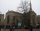
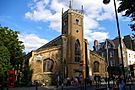
| St Andrew the Great |
 |
|
Andrew |
1485 Medieval |
Church of England |
52°12′18″N 0°07′18″E / 52.205°N 0.1217°E / 52.205; 0.1217 (St Andrew the Great) |
Medieval church demolished 1842, rebuilt in Victorian style. Redundant 1984; home to the congregation of Holy Sepulchre since 1994. |
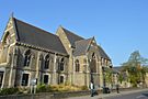
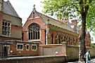
| St Augustine of Canterbury |
 |
|
Augustine of Canterbury |
|
Church of England |
52°13′11″N 0°06′28″E / 52.2198°N 0.1077°E / 52.2198; 0.1077 (St Augustine) |
Forms the Parish of the Ascension with St Giles's and St Peter's. Member of the 'Church at Castle' partnership |
| St Barnabas |
 |
|
Barnabas |
1869 |
Church of England |
52°11′59″N 0°08′16″E / 52.1996°N 0.1377°E / 52.1996; 0.1377 (St Barnabas) |
|
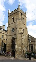
| St Bene't's |
 |
|
Benedict of Nursia |
1020 c. 1020 |
Church of England |
52°12′13″N 0°07′06″E / 52.2037°N 0.1183°E / 52.2037; 0.1183 (St Bene't) |
Oldest church in Cambridgeshire as well as the oldest building in Cambridge. |
| St Botolph's |
 |
|
Botwulf of Thorney |
1350 c. 1350 |
Church of England |
52°12′09″N 0°07′05″E / 52.2025°N 0.1181°E / 52.2025; 0.1181 (St Botolph) |
|
| St Clement's |
 |
|
? |
c. 1225 |
Church of England |
52°12′33″N 0°07′05″E / 52.2091°N 0.118°E / 52.2091; 0.118 (St Clement) |
|
| St Edward King and Martyr |
 |
|
Edward the Martyr |
c. 1250 |
Church of England |
52°12′17″N 0°07′07″E / 52.2046°N 0.1186°E / 52.2046; 0.1186 (St Edward) |
Rebuilt 1400. Royal Peculiar |
| St Giles' |
 |
|
Giles |
1092 |
Church of England |
52°12′40″N 0°06′53″E / 52.2111°N 0.1148°E / 52.2111; 0.1148 (St Giles) |
Forms the Parish of the Ascension with St Augustine's and St Peter's. Member of 'Church at Castle' partnership |
| St George |
 |
|
George |
1938 |
Church of England |
52°13′27″N 0°08′33″E / 52.2243°N 0.1425°E / 52.2243; 0.1425 (St George) |
|
| St James |
|
|
James |
1955 |
Church of England |
52°10′54″N 0°09′08″E / 52.1818°N 0.1522°E / 52.1818; 0.1522 (St James) |
|
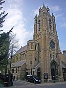
| St John the Evangelist |
 |
|
John the Evangelist |
1891 |
Church of England |
52°11′07″N 0°08′20″E / 52.1853°N 0.1390°E / 52.1853; 0.1390 (St John the Evangalist) |
|
| St Luke's |
 |
|
Luke |
1863 |
URC / CoE |
52°12′57″N 0°06′59″E / 52.2158°N 0.1163°E / 52.2158; 0.1163 (St Luke) |
Current structure erected 1873-1874. Local ecumenical partnership. Member of the 'Church at Castle' partnership |
| St Mark's |
 |
|
Mark |
1870 |
Church of England |
52°11′47″N 0°06′30″E / 52.1964°N 0.1082°E / 52.1964; 0.1082 (St Mark) |
Smaller wooden structure on site of current building in use until 1901 |
| St Martin's |
 |
|
Martin of Tours |
1932 |
Church of England |
52°11′35″N 0°09′01″E / 52.1931°N 0.1503°E / 52.1931; 0.1503 (St Martin) |
Services took place in temporary structures on the site of the current building until 1961 |
| St Mary the Great |
 |
|
Mary |
1205 |
Church of England |
52°12′19″N 0°07′06″E / 52.2053°N 0.1182°E / 52.2053; 0.1182 (St Mary the Great) |
|
| St Mary the Less |
 |
|
Mary |
1352 |
Church of England |
52°12′04″N 0°07′05″E / 52.2011°N 0.1181°E / 52.2011; 0.1181 (St Mary the Less) |
|
| SS Mary and Michael |
 |
|
Mary & Michael |
1200-1330 |
Church of England |
52°10′26″N 0°06′31″E / 52.1739°N 0.1085°E / 52.1739; 0.1085 (SS Mary & Michael) |
|
| St Matthew's |
 |
|
Matthew |
1866 |
Church of England |
52°12′20″N 0°08′17″E / 52.2056°N 0.1380°E / 52.2056; 0.1380 (St Matthew) |
Received a church graft from St Andrew the Great 2008 |
| St Paul's |
 |
|
Paul |
1841 |
Church of England |
52°11′51″N 0°07′46″E / 52.1976°N 0.1294°E / 52.1976; 0.1294 (St Paul) |
|
| St Philip's |
 |
|
Philip |
1889 |
Church of England |
52°11′51″N 0°08′45″E / 52.1976°N 0.1459°E / 52.1976; 0.1459 (St Philip) |
|
| St Thomas's Hall |
|
|
Thomas |
1980 |
Church of England |
52°11′30″N 0°09′25″E / 52.1918°N 0.1569°E / 52.1918; 0.1569 (St Thomas's Hall) |
Part of St Martin's parish; used regularly for services |
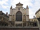
| Our Lady and the English Martyrs |
 |
|
Mary & Forty Martyrs |
1885-1890 |
Catholic Church |
52°11′56″N 0°07′38″E / 52.1988°N 0.1273°E / 52.1988; 0.1273 (OLEM) |
|
| St Laurence's |
 |
|
Lawrence of Rome |
1947 |
Catholic Church |
52°13′05″N 0°07′47″E / 52.2181°N 0.1296°E / 52.2181; 0.1296 (St Laurence) |
Permanent structure built 1958 |
| St Philip Howard |
|
|
Philip Howard |
1978 |
Catholic Church |
52°11′09″N 0°09′38″E / 52.1859°N 0.1606°E / 52.1859; 0.1606 (St Philip Howard) |
|
| St Vincent de Paul |
 |
|
Vincent de Paul |
1958 |
Catholic Church |
52°12′54″N 0°10′04″E / 52.2150°N 0.1679°E / 52.2150; 0.1679 (St Vincent de Paul) |
Parish of Our Lady and the English Martyrs. Current building was old St Laurence's until 1958 when it was moved to Fen Ditton |
| Fisher House University Catholic Chaplaincy |
 |
|
John Fisher |
1925 |
Catholic Church |
52°12′17″N 0°07′12″E / 52.2046°N 0.1199°E / 52.2046; 0.1199 (Fisher House) |
|
| St Athanasios |
 |
|
Athanasius of Alexandria |
1902 |
Greek Orthodox |
52°11′16″N 0°08′40″E / 52.1878°N 0.1445°E / 52.1878; 0.1445 (St Athanasios) |
Ecumenical Patriarchate of Constantinople, the building was formerly the Cherry Hinton Road United Reformed Church |
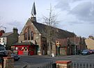
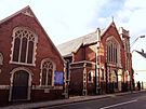
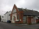
| Arbury Road Baptist Church |
 |
|
|
1842 |
Baptist Union |
52°13′18″N 0°08′01″E / 52.2217°N 0.1336°E / 52.2217; 0.1336 (Arbury Road Baptist) |
Originally called the Ebenezer. Moved to current site 1930. New chapel built 1966. |
| Barnwell Baptist Church |
|
|
|
|
Baptist Union |
52°12′58″N 0°09′46″E / 52.2162°N 0.1628°E / 52.2162; 0.1628 (Barnwell Baptist) |
|
| Cherry Hinton Baptist Church |
|
|
|
|
Baptist Union |
52°11′19″N 0°10′34″E / 52.1885°N 0.1760°E / 52.1885; 0.1760 (Cherry Hinton Baptist) |
|
| Mill Road Baptist Church |
 |
|
|
1881 |
Baptist Union |
52°11′52″N 0°08′36″E / 52.1978°N 0.1432°E / 52.1978; 0.1432 (Mill Road Baptist) |
|
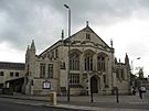
| St Andrew's Street Baptist Church |
 |
|
|
1721 |
Baptist Union |
52°12′10″N 0°07′26″E / 52.2027°N 0.1239°E / 52.2027; 0.1239 (St Andrew's Street Baptist) |
Rebuilt 1836, 1903 |
| Zion Baptist Church |
 |
|
Zion |
1837 |
Baptist Union |
52°12′13″N 0°07′57″E / 52.2035°N 0.1325°E / 52.2035; 0.1325 (Zion Baptist) |
Rebuilt 1879 |
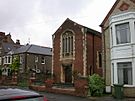
| Eden Baptist Church |
|
|
Eden |
1823 |
FIEC |
52°12′25″N 0°07′46″E / 52.2069°N 0.1295°E / 52.2069; 0.1295 (Eden Baptist) |
Originally a Strict and Particular Baptist chapel. Rebuilt 1874, 1982 |
| Castle Street Methodist Church |
 |
|
|
1823 |
Methodist Church |
52°12′41″N 0°06′49″E / 52.2115°N 0.1136°E / 52.2115; 0.1136 (Castle Street Methodist) |
Member of the 'Church at Castle' partnership. Built as a Primitive Methodist church; rebuilt 1841, 1863, 1914. |
| Chesterton Methodist Church |
 |
|
|
|
Methodist Church |
52°13′15″N 0°08′44″E / 52.2207°N 0.1456°E / 52.2207; 0.1456 (Chesterton Methodist) |
|
| Wesley Methodist Church |
 |
|
John Wesley |
1913 |
Methodist Church |
52°12′26″N 0°07′37″E / 52.2073°N 0.1269°E / 52.2073; 0.1269 (Wesley Methodist) |
|
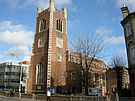
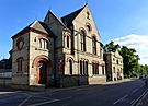
| Downing Place United Reformed Church |
 |
|
|
1687 |
United Reformed |
52°12′12″N 0°07′22″E / 52.2032°N 0.1227°E / 52.2032; 0.1227 (Downing Place URC) |
Founded from a merger of Emmanuel (1687) and St Columba's (c.1891); building dates from 1891 |
| German Lutheran Church |
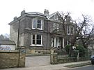 |
|
|
|
? |
52°11′26″N 0°07′51″E / 52.1906°N 0.1309°E / 52.1906; 0.1309 (German Lutheran Church) |
Aligned with the Evangelical Church in Germany (EKD) |
| Cambridge Salvation Army |
 |
|
|
1914 |
Salvation Army |
52°11′59″N 0°08′12″E / 52.1998°N 0.1368°E / 52.1998; 0.1368 (Salvation Army) |
|
| Cambridge Seventh-Day Adventist Church |
|
|
|
1920 |
Seventh-day Adventist Church |
52°11′45″N 0°09′09″E / 52.1959°N 0.1525°E / 52.1959; 0.1525 (Seventh-Day Adventist) |
Permanent building 1962 |
| North Arbury Chapel |
|
|
|
1976 |
Partnership UK |
52°13′51″N 0°07′46″E / 52.2308°N 0.1295°E / 52.2308; 0.1295 (North Arbury Chapel) |
|
| Roseford Chapel |
|
|
|
1959 |
? |
52°13′33″N 0°07′00″E / 52.2258°N 0.1167°E / 52.2258; 0.1167 (Roseford Chapel) |
|
| Queen Edith Chapel |
|
|
|
c. 1960 |
Partnership UK |
52°10′53″N 0°09′10″E / 52.1814°N 0.1529°E / 52.1814; 0.1529 (Queen Edith Chapel) |
|
| King's Church Cambridge |
 |
|
|
|
Assemblies of God |
52°11′55″N 0°08′10″E / 52.1986°N 0.1361°E / 52.1986; 0.1361 (King's Church) |
Building originally Tenison Road Baptist Chapel (opened 1897). Previously Living Waters Church. |
| C3 Church |
 |
|
|
c. 2015 |
? |
52°12′02″N 0°09′25″E / 52.2005°N 0.1570°E / 52.2005; 0.1570 (C3 Church) |
Formerly Cambridge Community Church. New church built on the site of St Stephen's Church, previously used the Free Church in Trumpington. |
| Memorial Unitarian Church |
 |
|
|
1904 |
Unitarian Church |
52°12′18″N 0°07′34″E / 52.2051°N 0.1261°E / 52.2051; 0.1261 (Memorial Unitarian) |
Permanent building 1927, designed by Ronald Potter Jones |
| Cambridge Chinese Christian Church |
 |
|
|
|
Interdenominational |
52°12′42″N 0°06′45″E / 52.2117°N 0.1124°E / 52.2117; 0.1124 (Cambridge Chinese Church) |
Castle End Mission (URC) until 2014. Built 1884 |
| Christadelphian Hall |
|
|
|
1954 |
Christadelphian |
52°12′06″N 0°09′09″E / 52.2018°N 0.1525°E / 52.2018; 0.1525 (Christadelphian Hall) |
|
| City of David Church |
|
|
|
2005 |
Redeemed Christian Church of God, Pentecostal |
52°11′15″N 0°09′18″E / 52.1875°N 0.155°E / 52.1875; 0.155 (City of David Church) |
Worship Centre located on Cherry Hinton Road |
| First Church of Christ Scientist |
|
|
|
|
Christian Science |
52°11′45″N 0°07′29″E / 52.1957°N 0.1248°E / 52.1957; 0.1248 (1st Church of Christ Scientist) |
The building shows the date 1866 |
| Kingdom Hall |
|
|
|
|
Jehovah's Witnesses |
52°12′46″N 0°08′50″E / 52.2127°N 0.1472°E / 52.2127; 0.1472 (Kingdom Hall) |
|
| Name |
Image |
Refs |
Dedication |
Founded |
Denomination |
Location |
Notes |
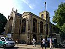
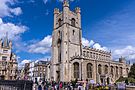
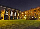
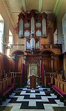
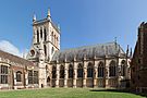
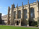
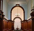
| King's College Chapel |
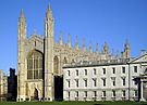 |
|
Mary & Nicholas |
1446-1515 |
Church of England |
52°12′17″N 0°06′59″E / 52.2048°N 0.1165°E / 52.2048; 0.1165 (King's College Chapel) |
|
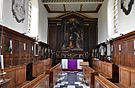
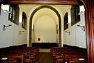
| Queens' College Chapel |
 |
|
Margaret the Virgin & Bernard of Clairvaux |
1450s |
Church of England |
52°12′10″N 0°06′57″E / 52.2029°N 0.1159°E / 52.2029; 0.1159 (Queens' College Chapel) |
Rebuilt in a different part of the college 1891 |
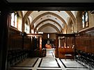
| Christ's College Chapel |
 |
|
|
c. 1440 |
Church of England |
52°12′21″N 0°07′20″E / 52.2057°N 0.1221°E / 52.2057; 0.1221 (Christ's College Chapel) |
Enlarged and reconsecrated 1510 when God's-house was refounded as Christ's |
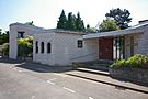
| Chapel at Churchill College |
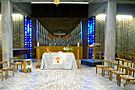 |
|
|
1967 |
Interdenominational |
52°12′51″N 0°05′49″E / 52.2142°N 0.0970°E / 52.2142; 0.0970 (Churchill College Chapel) |
|
| Clare College Chapel |
 |
|
Mary |
1363 |
Church of England |
52°12′19″N 0°06′57″E / 52.2053°N 0.1158°E / 52.2053; 0.1158 (Clare College Chapel) |
Rebuilt 1535. Current structure was built in 1763-1769 |
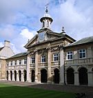
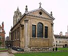
| Corpus Christi College Chapel |
 |
|
|
1577 |
Church of England |
52°12′11″N 0°07′07″E / 52.2030°N 0.1187°E / 52.2030; 0.1187 (Corpus Christi College Chapel) |
Previously the college used the nearby St Bene't's church. New chapel built 1827 by William Wilkins |
| Downing College Chapel |
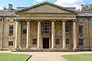 |
|
|
1950–1953 |
Church of England |
52°12′04″N 0°07′24″E / 52.2012°N 0.1233°E / 52.2012; 0.1233 (Downing College Chapel) |
The college spent over 150 years attempting to obtain a purpose-built chapel |
| Emmanuel College Chapel |
 |
|
|
c. 1590 |
Church of England |
52°12′14″N 0°07′28″E / 52.2039°N 0.1245°E / 52.2039; 0.1245 (Emmanuel College Chapel) |
Original chapel (previously dining hall of Dominican friary) became library. Current Christopher Wren structure 1677. |
| Fitzwilliam College Chapel |
 |
|
|
1991 |
Interdenominational |
52°12′54″N 0°06′20″E / 52.2150°N 0.1055°E / 52.2150; 0.1055 (Fitzwilliam College Chapel) |
|
| Girton College Chapel |
 |
|
|
1899–1902 |
Church of England |
52°13′41″N 0°05′03″E / 52.2281°N 0.0843°E / 52.2281; 0.0843 (Girton College Chapel) |
|
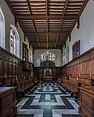
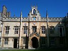
| Gonville and Caius College Chapel |
 |
|
|
1393 |
Church of England |
52°12′22″N 0°07′02″E / 52.2060°N 0.1172°E / 52.2060; 0.1172 (Gonville & Caius College Chapel) |
Oldest college chapel in either Oxford or Cambridge which has been in continuous use as such |
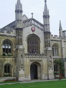
| Jesus College Chapel |
 |
|
|
1157–1245 |
Church of England |
52°12′32″N 0°07′27″E / 52.2090°N 0.1242°E / 52.2090; 0.1242 (Jesus College Chapel) |
Oldest university building in Cambridge still in use. Previously chapel of St Radegund's Priory until college was founded c. 1500 |
| Magdalene College Chapel |
 |
|
|
1470–1472 |
Church of England |
52°12′38″N 0°06′58″E / 52.2105°N 0.1162°E / 52.2105; 0.1162 (Magdalene College Chapel) |
|
| Pembroke College Chapel |
 |
|
|
c. 1350 |
Church of England |
52°12′06″N 0°07′07″E / 52.20155°N 0.1187°E / 52.20155; 0.1187 (Pembroke College Chapel) |
Original chapel (first bespoke college chapel in town) now Old Library; current chapel designed by Christopher Wren consecrated 1665 |
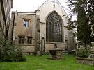
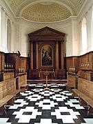
| Peterhouse Chapel |
 |
|
|
1628 |
Church of England |
52°12′04″N 0°07′07″E / 52.2010°N 0.1187°E / 52.2010; 0.1187 (Peterhouse College Chapel) |
College previously employed St Mary the Less as its chapel |
| Robinson College Chapel |
 |
|
|
1981 |
Interdenominational |
52°12′17″N 0°06′20″E / 52.2047°N 0.1055°E / 52.2047; 0.1055 (Robinson College Chapel) |
|
| St Catharine's College Chapel |
 |
|
|
1704 pre-1704 |
Church of England |
52°12′11″N 0°07′01″E / 52.20315°N 0.1169°E / 52.20315; 0.1169 (St Catharine's College Chapel) |
Rebuilt and reconsecrated 1704 |
| St Edmund's College Chapel |
 |
|
|
1916 |
Catholic Church |
52°12′47″N 0°06′31″E / 52.2130°N 0.1087°E / 52.2130; 0.1087 (St Edmund's College Chapel) |
|
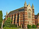
| St John's College Chapel |
 |
|
|
c. 1300 |
Church of England |
52°12′30″N 0°07′04″E / 52.2082°N 0.1178°E / 52.2082; 0.1178 (St John's College Chapel) |
Current structure constructed 1866-1869, designed by Sir George Gilbert Scott. Tallest structure in Cambridge |
| Selwyn College Chapel |
 |
|
|
1895 |
Church of England |
52°12′03″N 0°06′24″E / 52.20095°N 0.1068°E / 52.20095; 0.1068 (Selwyn College Chapel) |
|
| Sidney Sussex College Chapel |
 |
|
|
c. 1600 |
Church of England |
52°12′25″N 0°07′15″E / 52.2069°N 0.1208°E / 52.2069; 0.1208 (Sidney Sussex College Chapel) |
Previously a friary building; rebuilt 1776 |
| Trinity College Chapel |
 |
|
|
1554–1567 |
Church of England |
52°12′27″N 0°07′03″E / 52.2074°N 0.1175°E / 52.2074; 0.1175 (Trinity College Chapel) |
|
| Trinity Hall Chapel |
 |
|
|
1366 |
Church of England |
52°12′20″N 0°06′57″E / 52.2056°N 0.1157°E / 52.2056; 0.1157 (Trinity Hall College Chapel) |
|
| Memorial Chapel, The Leys School |
 |
|
|
1905 |
Methodist |
52°11′48″N 0°07′17″E / 52.1968°N 0.1214°E / 52.1968; 0.1214 (The Leys School Chapel) |
|
| Ridley Hall Chapel |
 |
|
|
After 1891 |
Church of England |
52°12′01″N 0°06′40″E / 52.2003°N 0.1110°E / 52.2003; 0.1110 (Ridley Hall Chapel) |
|
| Wesley House Chapel |
 |
|
|
1930 |
Methodist |
52°12′32″N 0°07′20″E / 52.2088°N 0.1222°E / 52.2088; 0.1222 (Wesley House Chapel) |
|
| Westcott House Chapel |
 |
|
|
|
Church of England |
52°12′28″N 0°07′22″E / 52.20785°N 0.1228°E / 52.20785; 0.1228 (Westcott House Chapel) |
|
| Westminster College Chapel |
 |
|
|
1897–1899 |
United Reformed |
52°12′39″N 0°06′44″E / 52.2107°N 0.1123°E / 52.2107; 0.1123 (Wesminster College Chapel) |
|
| Westfield House Chapel |
 |
|
Titus |
|
Evangelical Lutheran Church of England |
52°12′55″N 0°06′34″E / 52.2152°N 0.1095°E / 52.2152; 0.1095 (Resurrection Lutheran) |
Used by the local Lutheran congregation, Resurrection Lutheran Church |
| Name |
Image |
Refs |
Founded |
Defunct |
Denomination |
Location |
Notes |
| Michaelhouse |
 |
|
1324 |
1908 |
Church of England |
52°12′22″N 0°07′06″E / 52.2060°N 0.1183°E / 52.2060; 0.1183 (Michaelhouse) |
Combined with parish of St Mary the Great 1908. Now used as a cafe with occasional services. |
| St Peter's |
 |
|
c. 1150 |
|
Church of England |
52°12′40″N 0°06′50″E / 52.21107°N 0.1139°E / 52.21107; 0.1139 (St Peter) |
Managed by Churches Conservation Trust. Forms the Parish of the Ascension with St Augustine's and St Giles's. Member of the 'Church at Castle' partnership with St Giles's, St Augustine's, St Luke's (C of E/URC) and Castle Street Methodist Church. |
| All Saints |
 |
|
1863 |
1973 |
Church of England |
52°12′30″N 0°07′24″E / 52.2082°N 0.1232°E / 52.2082; 0.1232 (All Saints) |
Previously stood opposite St John's College in what is now All Saints' Churchyard; pulled down and rebuilt in current location 1863. Redundant 1973. Not used for Anglican services; joint benefice with the Holy Sepulchre (Round Church) parish which meets in St Andrew the Great church building |
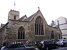
| Holy Sepulchre (The Round Church) |
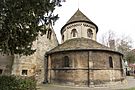 |
|
1130 |
|
Church of England |
52°12′30″N 0°07′08″E / 52.2084°N 0.1189°E / 52.2084; 0.1189 (Holy Sepulchre) |
Managed by Christian Heritage. Now a joint benefice with St Andrew the Great, where the parish's congregation meets |
| Leper Chapel (Chapel of St Mary Magdalene) |
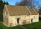 |
|
1125 c. 1125 |
|
Church of England |
52°12′50″N 0°09′09″E / 52.2139°N 0.1526°E / 52.2139; 0.1526 (Leper Chapel) |
Defunct and managed by the Cambridge Preservation Society. Oldest complete surviving building in Cambridge. In a united benefice with Christ the Redeemer and used for occasional services. |
| St Andrew The Less |
 |
|
1190 |
|
Church of England |
52°12′32″N 0°08′23″E / 52.20895°N 0.1397°E / 52.20895; 0.1397 (St Andrew the Less) |
In a united benefice with Christ Church and rarely, if ever, used for services |
| Emmanuel United Reformed Church |
 |
|
1874 |
2020 |
United Reformed |
52°12′05″N 0°07′06″E / 52.2014°N 0.1182°E / 52.2014; 0.1182 (Emmanuel URC) |
Congregation merged with St Columba's to form Downing Place URC. Building now belongs to Pembroke College. |
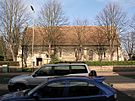
| Trumpington Free Church |
 |
|
1899 |
|
|
52°10′36″N 0°06′52″E / 52.1767°N 0.1145°E / 52.1767; 0.1145 (Trumpington Free Church) |
Formerly used by the Cambridge Community Chuch (C3 Church). |


.jpg)


.jpg)


.jpg)


.jpg)


.JPG)


.jpg)


