
List of counties in Utah facts for kids
Quick facts for kids Counties of Utah |
|
|---|---|
| Location | State of Utah |
| Number | 29 |
| Populations | 1,059 (Daggett) – 1,029,665 (Salt Lake) |
| Areas | 299 square miles (770 km2) (Davis) – 7,820 square miles (20,300 km2) (San Juan) |
| Government | County government |
| Subdivisions | cities, towns, townships, unincorporated communities, indian reservations, census designated place |

There are 29 counties in the U.S. state of Utah. There were originally seven counties established under the provisional State of Deseret in 1849: Davis, Iron, Sanpete, Salt Lake, Tooele, Utah, and Weber. The Territory of Utah was created in 1851 with the first territorial legislature meeting from 1851–1852. The first legislature re-created the original counties from the State of Deseret under territorial law as well as establishing three additional counties: Juab, Millard, and Washington. All other counties were established between 1854 and 1894 by the Utah Territorial Legislature under territorial law except for the last two counties formed, Daggett and Duchesne. They were created by popular vote and by gubernatorial proclamation after Utah became a state. Present-day Duchesne County encompassed an Indian reservation that was created in 1861. The reservation was opened to homesteaders in 1905 and the county was created in 1913. Due to dangerous roads, mountainous terrain, and bad weather preventing travel via a direct route, residents in present-day Daggett County had to travel 400 to 800 miles (640 to 1,290 km) on both stage and rail to conduct business in Vernal, the county seat for Uintah County a mere 50 miles away. In 1917, all Uintah County residents voted to create Daggett County.
Based on the 2010 United States Census data, the population of Utah was 2,763,885. Just over 75% of Utah's population is concentrated along four Wasatch Front counties of Salt Lake, Utah, Davis, and Weber. Salt Lake County was the largest county in the state with a population of 1,029,655, followed by Utah County with 516,564, Davis County with 306,479 and Weber County with 231,236. Daggett County was the least populated with 1,059 people. The largest county in land area is San Juan County with 7,821 square miles (20,260 km2) and Davis County is the smallest with 304 square miles (790 km2).
The Federal Information Processing Standard (FIPS) code, which is used by the United States government to uniquely identify states and counties, is provided with each county. Utah's FIPS code is 49, which when combined with any county code would be written as 49XXX. In the FIPS code column in the table below, each FIPS code links to the most current census data for that county.
Contents
Counties
| County |
FIPS code | County seat | Established | Origin | Etymology | Population(2010) | Area(2010) | Map |
|---|---|---|---|---|---|---|---|---|
| Beaver County | 001 | Beaver | 1856 | Part of Iron County | The many beavers in the area | 6,629 | 2,590 sq mi (6,708 km2) |
 |
| Box Elder County | 003 | Brigham City | 1856 | Part of Weber County | The many Box Elder trees in the area | 49,975 | 5,746 sq mi (14,882 km2) |
 |
| Cache County | 005 | Logan | 1857 | Part of Weber County | Caches of furs made by Rocky Mountain Fur Company trappers | 112,656 | 1,165 sq mi (3,017 km2) |
 |
| Carbon County | 007 | Price | 1894 | Part of Emery County | The vast coal beds in the county. | 21,403 | 1,478 sq mi (3,828 km2) |
 |
| Daggett County | 009 | Manila | 1919 | Part of Uintah County | Ellsworth Daggett (1810–1880), the first Utah Surveyor General | 1,059 | 697 sq mi (1,805 km2) |
 |
| Davis County | 011 | Farmington | 1850 | Original county of State of Deseret | Daniel C. Davis (1804–1850), Mormon Battalion captain | 306,479 | 299 sq mi (774 km2) |
 |
| Duchesne County | 013 | Duchesne | 1913 | Part of Wasatch County | Uncertain; likely origins are a Ute word translated "dark canyon", the French and Indian War site of Fort Duquesne (the county's initial settlement was also a fortress), the corrupted name of an area Indian chief, or the name of French fur trapper and explorer. | 18,607 | 3,241 sq mi (8,394 km2) |
 |
| Emery County | 015 | Castle Dale | 1880 | Part of Sanpete County | George W. Emery (1830–1909), Governor of the Utah Territory from 1875–1880 | 10,976 | 4,462 sq mi (11,557 km2) |
 |
| Garfield County | 017 | Panguitch | 1882 | Part of Iron County | James A. Garfield (1831–1881), President of the United States in 1881 | 5,172 | 5,175 sq mi (13,403 km2) |
 |
| Grand County | 019 | Moab | 1890 | Part of Emery County | The Grand River, since renamed to the Colorado River | 9,225 | 3,672 sq mi (9,510 km2) |
 |
| Iron County | 021 | Parowan | 1850 | Original county of State of Deseret | Iron mines west of Cedar City. | 46,163 | 3,297 sq mi (8,539 km2) |
 |
| Juab County | 023 | Nephi | 1852 | Original county of Territory of Utah | A Native American word translated "thirsty valley" | 10,246 | 3,392 sq mi (8,785 km2) |
 |
| Kane County | 025 | Kanab | 1864 | Part of Washington County | Thomas L. Kane (1822–1883), U.S. Army officer who spoke in favor of the Mormon migration and settlement of Utah | 7,125 | 3,990 sq mi (10,334 km2) |
 |
| Millard County | 027 | Fillmore | 1851 | Original county of Territory of Utah | Millard Fillmore (1800–1874), President of the United States from 1850 to 1853 | 12,503 | 6,572 sq mi (17,021 km2) |
 |
| Morgan County | 029 | Morgan | 1862 | Part of Davis County | Jedediah Morgan Grant (1816–1856), an Apostle of The Church of Jesus Christ of Latter-day Saints | 9,469 | 609 sq mi (1,577 km2) |
 |
| Piute County | 031 | Junction | 1865 | Part of Beaver County | The Piute tribe of Native Americans who lived in the area | 1,556 | 758 sq mi (1,963 km2) |
 |
| Rich County | 033 | Randolph | 1864 | Part of Cache County | Charles C. Rich (1809–1883), an Apostle of The Church of Jesus Christ of Latter-day Saints | 2,264 | 1,029 sq mi (2,665 km2) |
 |
| Salt Lake County | 035 | Salt Lake City | 1849 | Original county of State of Deseret | The Great Salt Lake, the largest terminal lake in the Western Hemisphere | 1,029,665 | 742 sq mi (1,922 km2) |
 |
| San Juan County | 037 | Monticello | 1880 | Parts of Kane, Iron, and Piute counties | Named for the San Juan River, a 400-mile (640 km) tributary of the Colorado river located in southern Colorado and Utah | 14,746 | 7,820 sq mi (20,254 km2) |
 |
| Sanpete County | 039 | Manti | 1849 | Original county of State of Deseret | Uncertain, possibly from a Ute Chief named San Pitch | 27,882 | 1,590 sq mi (4,118 km2) |
 |
| Sevier County | 041 | Richfield | 1862 | Part of Sanpete County | The Sevier River, a 280-mile (450 km) mile river in central Utah | 20,802 | 1,911 sq mi (4,949 km2) |
 |
| Summit County | 043 | Coalville | 1854 | Part of Salt Lake and Green River counties | High elevations in the county, which includes 39 of Utah's highest peaks | 36,324 | 1,872 sq mi (4,848 km2) |
 |
| Tooele County | 045 | Tooele | 1849 | Original county of State of Deseret | Uncertain, either from the Goshute Tribe Chief Tuilla or the Tules plant that grew in the marshes | 58,218 | 6,941 sq mi (17,977 km2) |
 |
| Uintah County | 047 | Vernal | 1880 | Part of Wasatch | The Uintah band of the Ute tribe who lived in the area | 32,588 | 4,480 sq mi (11,603 km2) |
 |
| Utah County | 049 | Provo | 1849 | Original county of State of Deseret | Yuta, the Spanish name for the Ute tribe | 516,564 | 2,003 sq mi (5,188 km2) |
 |
| Wasatch County | 051 | Heber City | 1862 | Part of Utah and Sanpete counties | A Native American word meaning "mountain pass", also the name of the Wasatch Range | 23,530 | 1,176 sq mi (3,046 km2) |
 |
| Washington County | 053 | St. George | 1852 | Original county of Territory of Utah | George Washington (1732–1799), President of the United States from 1789 to 1797 | 138,115 | 2,426 sq mi (6,283 km2) |
 |
| Wayne County | 055 | Loa | 1892 | Part of Piute County | Wayne Robinson, the son of Utah state legislator Willis Robinson, who was killed by a horse while both men traveled to a legislative session. | 2,589 | 2,461 sq mi (6,374 km2) |
 |
| Weber County | 057 | Ogden | 1849 | Original county of State of Deseret | The Weber River, a 125 miles (201 km) tributary of the Great Salt Lake | 231,236 | 576 sq mi (1,492 km2) |
 |
Former counties
There were ten counties in the Territory of Utah that were absorbed by other states or Utah counties.
| County | Established | Superseded | Etymology | Present location |
|---|---|---|---|---|
| Carson County | 1854 | 1861 | Named for the Carson River, a 150-mile (240 km) river in Nevada and California that originates from the Sierra Nevada Mountains | Nevada |
| Cedar County | 1856 | 1862 | Named for the numerous cedar trees growing in the area (which are actually juniper trees) | Utah County |
| Desert County | 1852 | 1862 | Named for the surrounding desert | Box Elder County, Tooele County and Nevada |
| Greasewood County | 1856 | 1862 | Named for the greasewood plant growing in the area | Box Elder County |
| Green River County | 1852 | 1872 | Named for the Green River, a 730-mile (1,170 km) tributary of the Colorado River that runs through Wyoming, Colorado and Utah | Cache, Weber, Morgan, Davis, Wasatch, Summit, Duchesne, Carbon, and Utah Counties, and Wyoming and Colorado |
| Humboldt County | 1856 | 1861 | Named for the Humboldt River, a 300-mile (480 km) river in Nevada and longest river in the Great Basin | Nevada |
| Malad County | 1856 | 1862 | Named for the Malad River, the name being French for "sickly" | Box Elder County |
| Rio Virgin County | 1869 | 1872 | Named for the Virgin River, a 160 miles (260 km) long tributary of the Colorado River located in southern Utah and Nevada | Washington County, Nevada and Arizona |
| St. Mary's County | 1856 | 1861 | Named after the Mary's River, which was later renamed to the Humboldt River | Nevada |
| Shambip County | 1856 | 1862 | Goshute Native American Tribe word for Rush Lake | Tooele County |
Images for kids
-
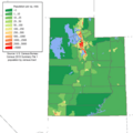
Population density of Utah counties

See also
 In Spanish: Anexo:Condados de Utah para niños
