
List of districts of Andhra Pradesh facts for kids
Quick facts for kids Districts of Andhra Pradesh |
|
|---|---|

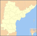
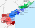
Andhra Pradesh Political Map
|
|
| Category | Districts |
| Location | Andhra Pradesh |
| Number | 26 districts |
| Populations | Parvathipuram Manyam – 9,25,340 (lowest); Nellore – 24,69,712 (highest) |
| Areas | Visakhapatnam – 1,048 km2 (405 sq mi)(smallest); Prakasam – 14,322 km2 (5,530 sq mi)(largest) |
| Government | Government of Andhra Pradesh |
| Subdivisions | Revenue Divisions of Andhra Pradesh |
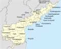
The state of Andhra Pradesh has 26 districts spread across three cultural regions: Uttaraandhra, Kostaandhra and Rayalaseema. Uttaarandhra consists of Srikakulam, Vizianagaram, Parvathipuram Manyam, Alluri Sitharama Raju, Visakhapatnam and Anakapalli districts. Coastal andhra comprises Kakinada, Dr. B. R. Ambedkar Konaseema, East Godavari, West Godavari, Eluru, Krishna, NTR, Guntur, Palnadu, Bapatla, Prakasam and Sri Potti Sriramulu Nellore districts. Rayalaseema consists of Kurnool, Nandyal, Anantapuramu, Sri Sathya Sai, YSR, Annamayya, Tirupati and Chittoor districts.
Visakhapatnam district is the smallest district in area while Prakasam district is the largest. Sri Potti Sriramulu Nellore district is the most populous whereas Parvathipuram Manyam district is the least populous district. The districts are further divided into two or more revenue divisions, which are further subdivided into mandals for administrative purposes.
History
At the time of Independence the present day Andhra Pradesh was a part of the Madras State. The telugu speaking dominant regions Kostaandhra and Rayalaseema were separated from Madras State to form Andhra State in 1953.
As Andhra State, it consisted of 11 districts which are Anantapur, Chittoor, East Godavari, Guntur, Kadapa, Krishna, Kurnool, Nellore, Srikakulam, Visakhapatnam and West Godavari.
As a result of the 1956 States Reorganisation Act, the state's boundaries were re-organized following linguistic lines. On 1 November 1956, the Andhra State and the Telangana region of the Hyderabad State were merged to form the Andhra Pradesh which is retrospectively referred to as United Andhra Pradesh.
As united Andhra Pradesh, it consisted of 21 district's, with 10 districts of Telangana region. In the year 1959, Bhadrachalam and Nuguru Venkatapuram taluks of East Godavari district, which are on the other side of the Godavari River, were merged into Khammam district on grounds of geographical contiguity and administrative viability. Similarly Aswaraopeta part of West Godavari District was added to Khammam district and Munagala taluk belonging to Krishna district was added to Nalgonda district in the same year.
The number of districts became 23 with the formation of Prakasam district from the parts of Guntur, Nellore and Kurnool district's in 1970 and Vizianagaram district from parts of Visakhapatnam and Srikakulam districts in 1979.
After the bifurcation of the United Andhra Pradesh in 2014, the Andhra region now known as Andhra Pradesh was left with 13 districts but was given several tribal-dominated mandals from the Khammam district of the Telangana as part of the Polavaram project. These mandals were added to the East Godavari and West Godavari district's respectively.
On 26 January 2022, the Government of Andhra Pradesh had proposed 13 new districts by issuing a draft notification under the Andhra Pradesh Districts (Formation) Act, 1974, Section 3(5). After taking the objections and suggestions received from the public into consideration, the government has published the final notification on 3 April 2022. With effect from 4 April 2022 the newly formed districts came into effect as specified in the schedule. At present there are 26 districts spread across 3 cultural regions: Uttaraandhra, Kostaandhra and Rayalaseema.
Timeline
-
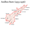
(1953–1956)
-
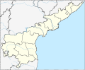
(1956–2014)
-
(2014–2022)
-
(2022–2023)
-
(2023 - )
.png)
.png)


Districts
| S.No | Code | Official name | Headquarters | Revenue divisions |
Mandals | Population | Area (in sq.km) |
Density (per sq.km) |
Map |
|---|---|---|---|---|---|---|---|---|---|
| 1 | SRI | Srikakulam | Srikakulam | 3 | 30 | 21,91,471 | 4,591 | 477.34 | .svg) |
| 2 | PAR | Parvathipuram Manyam | Parvathipuram | 2 | 15 | 9,25,340 | 3,659 | 252.89 | .svg) |
| 3 | VIZ | Vizianagaram | Vizianagaram | 3 | 27 | 19,30,811 | 4,122 | 468.42 | .svg) |
| 4 | VIS | Visakhapatnam | Visakhapatnam | 2 | 11 | 19,59,544 | 1,048 | 1869.79 | .svg) |
| 5 | ALL | Alluri Sitharama Raju | Paderu | 3 | 22 | 9,53,960 | 12,251 | 77.87 | .svg) |
| 6 | ANA | Anakapalli | Anakapalli | 2 | 25 | 17,26,998 | 4,292 | 402.38 | .svg) |
| 7 | KAK | Kakinada | Kakinada | 2 | 21 | 20,92,374 | 3,019 | 693.07 | .svg) |
| 8 | EAS | East Godavari | Rajamahendravaram | 2 | 19 | 18,32,332 | 2,561 | 715.48 | .svg) |
| 9 | KON | Dr. B. R. Ambedkar Konaseema | Amalapuram | 3 | 22 | 17,19,093 | 2,083 | 825.30 | .svg) |
| 10 | ELU | Eluru | Eluru | 3 | 27 | 20,06,737 | 6,579 | 305.02 | |
| 11 | WES | West Godavari | Bhimavaram | 3 | 20 | 18,44,898 | 2,278 | 809.88 | |
| 12 | NTR | NTR | Vijayawada | 3 | 20 | 22,18,591 | 3,316 | 669.06 | .svg) |
| 13 | KRI | Krishna | Machilipatnam | 3 | 26 | 17,35,079 | 3,775 | 459.62 | .svg) |
| 14 | PAL | Palnadu | Narasaraopeta | 3 | 28 | 20,41,723 | 7,298 | 279.76 | .svg) |
| 15 | GUN | Guntur | Guntur | 2 | 18 | 20,91,075 | 2,443 | 855.95 | .svg) |
| 16 | BAP | Bapatla | Bapatla | 3 | 25 | 15,86,918 | 3,829 | 414.45 | .svg) |
| 17 | PRA | Prakasam | Ongole | 3 | 39 | 22,88,026 | 14,322 | 159.76 | .svg) |
| 18 | NEL | Sri Potti Sriramulu Nellore | Nellore | 4 | 38 | 24,69,712 | 10,441 | 236.54 | .svg) |
| 19 | KUR | Kurnool | Kurnool | 3 | 26 | 22,71,686 | 7,980 | 284.67 | .svg) |
| 20 | NAN | Nandyal | Nandyal | 3 | 30 | 17,81,777 | 9,682 | 184.03 | .svg) |
| 21 | ANA | Anantapur | Anantapur | 3 | 32 | 22,41,105 | 10,205 | 219.61 | .svg) |
| 22 | SSS | Sri Sathya Sai | Puttaparthi | 4 | 32 | 18,40,043 | 8,925 | 206.17 | .svg) |
| 23 | CUD | YSR | Kadapa | 4 | 36 | 20,60,654 | 11,228 | 183.53 | .svg) |
| 24 | ANN | Annamayya | Rayachoti | 3 | 30 | 16,97,308 | 7,954 | 213.39 | .svg) |
| 25 | TIR | Tirupati | Tirupati | 4 | 34 | 21,96,984 | 8,231 | 266.92 | .svg) |
| 26 | CHI | Chittoor | Chittoor | 4 | 32 | 18,72,951 | 6,855 | 273.22 | .svg) |
- Source:
<mapframe width="500" height="500" text="Districts in Andhra Pradesh, zoom and click for interactive identification map" align=center> { "type": "ExternalData", "service": "geoshape", "query": "SELECT ?id ?idLabel (concat('', ?idLabel, '') as ?title) \n WHERE \n { \n ?id wdt:P31 wd:Q1149652 . # is a \n ?id wdt:P131 wd:Q1159 . # in India \n SERVICE wikibase:label { bd:serviceParam wikibase:language 'en' } \n }"} </mapframe>
See also
 In Spanish: Anexo:Distritos del estado de Andhra Pradesh para niños
- List of mandals in Andhra Pradesh
- List of districts in India
- List of revenue divisions in Andhra Pradesh
