
List of highest mountains facts for kids

This is a list of the highest mountains in the world. There are at least 109 mountains on Earth that are higher than 7,200 metres (23,622 ft) above sea level. Most of these are in central or southern Asia. It is hard to measure how tall a mountain is, so these measurements may not be exact. It is also hard to figure out if two peaks close to each other are part of the same mountain or are two different mountains.
Contents
List
| Rank | Mountain | Height (m) | Height (ft) | Range | Coordinates | Prominence (m) | Parent mountain | First ascent | Ascents (attempts) bef.2004 |
|---|---|---|---|---|---|---|---|---|---|
| 1 | Mount Everest/ Sagarmatha / Chomolungma |
8,848 | 29,029 | Mahalangur Himalaya | 27°59′17″N 86°55′31″E / 27.98806°N 86.92528°E | 8,848 | none | 1953 | 145 (121) |
| 2 | K2/ Qogir/ Godwin Austen |
8,611 | 28,251 | Baltoro Karakoram | 35°52′57″N 76°30′48″E / 35.88250°N 76.51333°E | 4,017 | Mount Everest | 1954 | 45 (44) |
| 3 | Kangchenjunga | 8,586 | 28,169 | Kangchenjunga Himalaya | 27°42′09″N 88°08′49″E / 27.70250°N 88.14694°E | 3,922 | Mount Everest | 1955 | 38 (24) |
| 4 | Lhotse | 8,516 | 27,940 | Mahalangur Himalaya | 27°57′42″N 86°55′59″E / 27.96167°N 86.93306°E | 610 | Mount Everest | 1956 | 26 (26) |
| 5 | Makalu | 8,485 | 27,838 | Mahalangur Himalaya | 27°53′21″N 87°05′19″E / 27.88917°N 87.08861°E | 2,386 | Mount Everest (Lhotse) | 1955 | 45 (52) |
| 6 | Cho Oyu | 8,188 | 26,864 | Mahalangur Himalaya | 28°05′39″N 86°39′39″E / 28.09417°N 86.66083°E | 2,340 | Mount Everest | 1954 | 79 (28) |
| 7 | Dhaulagiri I | 8,167 | 26,795 | Dhaulagiri Himalaya | 28°41′45″N 83°29′36″E / 28.69583°N 83.49333°E | 3,357 | K2 | 1960 | 51 (39) |
| 8 | Manaslu | 8,163 | 26,781 | Manaslu Himalaya | 28°32′58″N 84°33′39″E / 28.54944°N 84.56083°E | 3,092 | Cho Oyu | 1956 | 49 (45) |
| 9 | Nanga Parbat | 8,126 | 26,660 | Nanga Parbat Himalaya | 35°14′18″N 74°35′22″E / 35.23833°N 74.58944°E | 4,608 | Dhaulagiri | 1953 | 52 (67) |
| 10 | Annapurna I | 8,091 | 26,545 | Annapurna Himalaya | 28°35′43″N 83°49′11″E / 28.59528°N 83.81972°E | 2,984 | Cho Oyu | 1950 | 36 (47) |
| 11 | Gasherbrum I | 8,080 | 26,509 | Baltoro Karakoram | 35°43′27″N 76°41′44″E / 35.72417°N 76.69556°E | 2,155 | K2 | 1958 | 31 (16) |
| 12 | Broad Peak | 8,051 | 26,414 | Baltoro Karakoram | 35°48′38″N 76°34′05″E / 35.81056°N 76.56806°E | 1,701 | Gasherbrum I | 1957 | 39 (19) |
| 13 | Gasherbrum II | 8,034 | 26,362 | Baltoro Karakoram | 35°45′27″N 76°39′11″E / 35.75750°N 76.65306°E | 1,523 | Gasherbrum I | 1956 | 54 (12) |
| 14 | Shishapangma | 8,027 | 26,335 | Jugal Himalaya | 28°21′12″N 85°46′43″E / 28.35333°N 85.77861°E | 2,897 | Cho Oyu | 1964 | 43 (19) |
| 15 | Gyachung Kang | 7,952 | 26,089 | Mahalangur Himalaya | 28°05′52″N 86°44′47″E / 28.09778°N 86.74639°E | 700 | Cho Oyu | 1964 | 5 (3) |
| Gasherbrum III | 7,946 | 26,070 | Baltoro Karakoram | 35°45′34″N 76°38′31″E / 35.75944°N 76.64194°E | 355 | Gasherbrum II | 1975 | 2 (2) | |
| 16 | Annapurna II | 7,937 | 26,040 | Annapurna Himalaya | 28°32′03″N 84°07′20″E / 28.53417°N 84.12222°E | 2,437 | Annapurna I | 1960 | 6 (19) |
| 17 | Gasherbrum IV | 7,932 | 26,024 | Baltoro Karakoram | 35°45′33″N 76°36′57″E / 35.75917°N 76.61583°E | 715 | Gasherbrum III | 1958 | 4 (11) |
| 18 | Himalchuli | 7,893 | 25,896 | Manaslu Himalaya | 28°26′07″N 84°38′24″E / 28.43528°N 84.64000°E | 1,633 | Manaslu | 1960 | 6 (12) |
| 19 | Distaghil Sar | 7,884 | 25,866 | Hispar Karakoram | 36°19′33″N 75°11′18″E / 36.32583°N 75.18833°E | 2,525 | K2 | 1960 | 3 (5) |
| 20 | Ngadi Chuli | 7,871 | 25,823 | Manaslu Himalaya | 28°30′12″N 84°34′03″E / 28.50333°N 84.56750°E | 1,020 | Manaslu | 1970 | 2 (6) |
| Nuptse | 7,864 | 25,801 | Mahalangur Himalaya | 27°58′02″N 86°53′10″E / 27.96722°N 86.88611°E | 319 | Lhotse | 1961 | 5 (12) | |
| 21 | Khunyang Chhish | 7,823 | 25,666 | Hispar Karakoram | 36°12′19″N 75°12′28″E / 36.20528°N 75.20778°E | 1,765 | Distaghil Sar | 1971 | 2 (6) |
| 22 | Masherbrum | 7,821 | 25,659 | Masherbrum Karakoram | 35°38′28″N 76°18′21″E / 35.64111°N 76.30583°E | 2,457 | Gasherbrum I | 1960 | 4 (9) |
| 23 | Nanda Devi | 7,816 | 25,643 | Garhwal Himalaya | 30°22′36″N 79°58′15″E / 30.37667°N 79.97083°E | 3,139 | Dhaulagiri | 1936 | 14 (12) |
| 24 | Chomo Lonzo | 7,804 | 25,604 | Mahalangur Himalaya | 27°55′48″N 87°06′29″E / 27.93000°N 87.10806°E | 590 | Makalu | 1954 | 3 (1) |
| 25 | Batura Sar | 7,795 | 25,574 | Batura Karakoram | 36°30′36″N 74°31′27″E / 36.51000°N 74.52417°E | 3,118 | Distaghil Sar | 1976 | 4 (6) |
| 26 | Kanjut Sar | 7,790 | 25,558 | Hispar Karakoram | 36°12′18″N 75°25′04″E / 36.20500°N 75.41778°E | 1,690 | Khunyang Chhish | 1959 | 2 (1) |
| 27 | Rakaposhi | 7,788 | 25,551 | Rakaposhi-Haramosh Karakoram | 36°08′33″N 74°29′21″E / 36.14250°N 74.48917°E | 2,818 | Khunyang Chhish | 1958 | 8 (13) |
| 28 | Namcha Barwa | 7,782 | 25,531 | Assam Himalaya | 29°37′50″N 95°03′19″E / 29.63056°N 95.05528°E | 4,106 | Kangchenjunga | 1992 | 1 (2) |
| 29 | Kamet | 7,756 | 25,446 | Garhwal Himalaya | 30°55′12″N 79°35′30″E / 30.92000°N 79.59167°E | 2,825 | Nanda Devi | 1931 | 23 (14) |
| 30 | Dhaulagiri II | 7,751 | 25,430 | Dhaulagiri Himalaya | 28°45′46″N 83°23′14″E / 28.76278°N 83.38722°E | 2,396 | Dhaulagiri | 1971 | 4 (11) |
| 31 | Saltoro Kangri | 7,742 | 25,400 | Saltoro Karakoram | 35°23′57″N 76°50′51″E / 35.39917°N 76.84750°E | 2,160 | Gasherbrum I | 1962 | 2 (1) |
| 32 | Jannu | 7,711 | 25,299 | Kangchenjunga Himalaya | 27°40′54″N 88°02′36″E / 27.68167°N 88.04333°E | 1,036 | Kangchenjunga | 1962 | 17 (12) |
| 33 | Tirich Mir | 7,708 | 25,289 | Hindu Kush | 36°15′19″N 71°50′30″E / 36.25528°N 71.84167°E | 3,910 | Batura Sar | 1950 | 20 (11) |
| Molamenqing | 7,703 | 25,272 | Langtang Himalaya | 28°21′17″N 85°48′39″E / 28.35472°N 85.81083°E | 430 | Shishapangma | 1981 | 1 (0) | |
| 34 | Gurla Mandhata | 7,694 | 25,243 | Nalakankar Himalaya | 30°26′17″N 81°17′53″E / 30.43806°N 81.29806°E | 2,788 | Dhaulagiri | 1985 | 6 (4) |
| 35 | Saser Kangri I | 7,672 | 25,171 | Saser Karakoram | 34°52′00″N 77°45′09″E / 34.86667°N 77.75250°E | 2,304 | Gasherbrum I | 1973 | 6 (4) |
| 36 | Chogolisa | 7,665 | 25,148 | Masherbrum Karakoram | 35°36′42″N 76°34′18″E / 35.61167°N 76.57167°E | 1,624 | Masherbrum | 1975 | 4 (2) |
| Dhaulagiri IV | 7,661 | 25,135 | Dhaulagiri Himalaya | 28°44′09″N 83°18′55″E / 28.73583°N 83.31528°E | 469 | Dhaulagiri II | 1975 | 2 (10) | |
| 37 | Kongur Tagh | 7,649 | 25,095 | Kongur Shan Kunlun | 38°35′36″N 75°18′48″E / 38.59333°N 75.31333°E | 3,585 | Distaghil Sar | 1981 | 2 (4) |
| Dhaulagiri V | 7,618 | 24,993 | Dhaulagiri Himalaya | 28°44′02″N 83°21′41″E / 28.73389°N 83.36139°E | 340 | Dhaulagiri IV | 1975 | 2 (3) | |
| 38 | Shispare | 7,611 | 24,970 | Batura Karakoram | 36°26′26″N 74°40′51″E / 36.44056°N 74.68083°E | 1,240 | Batura Sar | 1974 | 3 (1) |
| 39 | Trivor | 7,577 | 24,859 | Hispar Karakoram | 36°17′15″N 75°05′10″E / 36.28750°N 75.08611°E | 980 | Distaghil Sar | 1960 | 2 (5) |
| 40 | Gangkhar Puensum | 7,570 | 24,836 | Kula Kangri Himalaya | 28°02′48″N 90°27′21″E / 28.04667°N 90.45583°E | 2,995 | Kangchenjunga | unclimbed | 0 (3) |
| 41 | Gongga Shan/ Minya Konka |
7,556 | 24,790 | Daxue Shan | 29°35′43″N 101°52′47″E / 29.59528°N 101.87972°E | 3,642 | Mount Everest | 1932 | 6 (7) |
| 42 | Annapurna III | 7,555 | 24,787 | Annapurna Himalaya | 28°35′05″N 83°59′28″E / 28.58472°N 83.99111°E | 703 | Annapurna I | 1961 | 10 (17) |
| 43 | Muztagh Ata | 7,546 | 24,757 | Muztagata Kunlun | 38°16′42″N 75°06′57″E / 38.27833°N 75.11583°E | 2,735 | Kongur Tagh | 1956 | many |
| 44 | Skyang Kangri | 7,545 | 24,754 | Baltoro Karakoram | 35°55′35″N 76°34′03″E / 35.92639°N 76.56750°E | 1,085 | K2 | 1976 | 1 (2) |
| 45 | Changtse | 7,543 | 24,747 | Mahalangur Himalaya | 28°01′29″N 86°54′31″E / 28.02472°N 86.90861°E | 520 | Mount Everest | 1982 | 9 (9) |
| 46 | Kula Kangri | 7,538 | 24,731 | Kula Kangri Himalaya | 28°13′34″N 90°36′54″E / 28.22611°N 90.61500°E | 1,650 | Gangkhar Puensum | 1986 | 3 (2) |
| 47 | Kongur Tiube | 7,530 | 24,705 | Kongur Shan Kunlun | 38°36′59″N 75°11′55″E / 38.61639°N 75.19861°E | 840 | Kongur Tagh | 1956 | 2 (3) |
| 48 | Mamostong Kangri | 7,516 | 24,659 | Rimo Karakoram | 35°08′27″N 77°34′39″E / 35.14083°N 77.57750°E | 1,803 | Gasherbrum I | 1984 | 5 (0) |
| 49 | Saser Kangri II E | 7,513 | 24,649 | Saser Karakoram | 34°48′15″N 77°48′18″E / 34.80417°N 77.80500°E | 1,450 | Saser Kangri I | 2011 | 0 (0) |
| 50 | Ismoil Somoni Peak | 7,495 | 24,590 | Pamir (Akademiya Nauk Range) | 38°56′32″N 72°00′57″E / 38.94222°N 72.01583°E | 3,402 | Muztagh Ata | 1933 |
Gallery
-
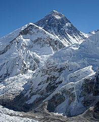
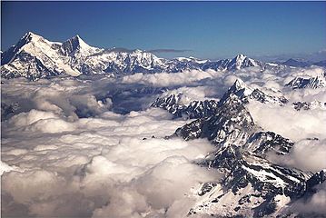
1. The summit of Mount Everest, the highest point on Earth
-
3. Kangchenjunga, the second-highest mountain of the Himalaya
-
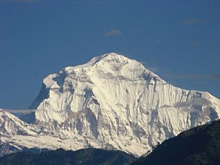
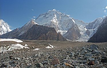
7. Dhaulagiri in the Himalaya
-
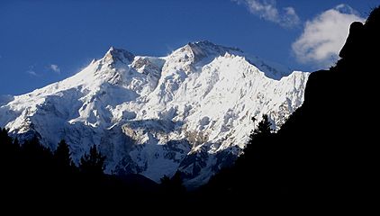
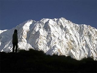
9. Nanga Parbat in the Himalaya
-
10. Annapurna I in the Himalaya
-
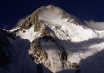
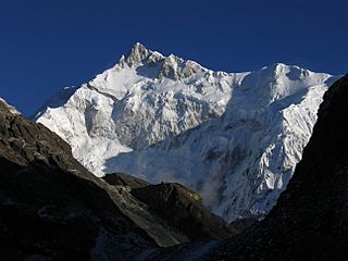
11. Gasherbrum I, the second-highest mountain of the Karakoram
-
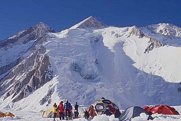
12. Broad Peak, the third-highest mountain of the Karakoram
-
13. Gasherbrum II in the Karakoram
-
14. Shishapangma in the Himalaya


Related pages
Images for kids
-

Figure demonstrating the concept of topographic prominence: The prominence of a peak is the height of the peak's summit above the lowest contour line encircling it and no higher summit. For example, vertical arrows show the topographic prominence of three peaks on an island. A dotted horizontal line links each peak (except the highest) to its key col.
See also
 In Spanish: Anexo:Montañas más altas de la Tierra para niños
