
Lofa County facts for kids
Quick facts for kids
Lofa County
|
||
|---|---|---|
|
County
|
||
|
||
| Nickname(s):
Tambah Nyumah
|
||

Location in Liberia
|
||
| Country | ||
| Capital | Voinjama | |
| Districts | 6 | |
| Established | 1964 | |
| Area | ||
| • Total | 9,982 km2 (3,854 sq mi) | |
| Population
(2008)
|
||
| • Total | 270,114 | |
| • Density | 27.1/km2 (70/sq mi) | |
| Time zone | UTC+0 (GMT) | |

Lofa County is a county in Liberia.
The county is bordered by Bong County to the south and Gbarpolu County to the west. The northwestern parts of Lofa border the nation of Sierra Leone. The northeastern parts border Guinea. Mount Wuteve, the highest mountain in Liberia, is in the county.
Images for kids
-
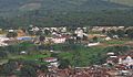
A view of Voinjama

See also
 In Spanish: Condado de Lofa para niños

All content from Kiddle encyclopedia articles (including the article images and facts) can be freely used under Attribution-ShareAlike license, unless stated otherwise. Cite this article:
Lofa County Facts for Kids. Kiddle Encyclopedia.