
Logan Village, Queensland facts for kids
Quick facts for kids Logan VillageLogan City, Queensland |
|||||||||||||||
|---|---|---|---|---|---|---|---|---|---|---|---|---|---|---|---|

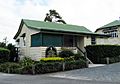
Hotz Road, 2014
|
|||||||||||||||

Logan Village
Location in Queensland
|
|||||||||||||||
| Population | 4,417 (2016 census) | ||||||||||||||
| • Density | 111.82/km2 (289.6/sq mi) | ||||||||||||||
| Postcode(s) | 4207 | ||||||||||||||
| Area | 39.5 km2 (15.3 sq mi) | ||||||||||||||
| Time zone | AEST (UTC+10:00) | ||||||||||||||
| Location |
|
||||||||||||||
| LGA(s) | Logan City | ||||||||||||||
| State electorate(s) | Logan | ||||||||||||||
| Federal Division(s) | Wright | ||||||||||||||
|
|||||||||||||||
Logan Village is a semi-rural town and locality in the City of Logan, Queensland, Australia. In the 2016 census, the locality of Logan Village had a population of 4,417 people. Logan Village was once known as the head of the navigable Logan River. Its importance as a town grew again when the railway arrived.
Contents
Geography
Logan Village is a low density semi-rural suburb. The area has remained remote with few commercial or retail outlets. The Logan River passes through the middle of the suburb as does the disused railway from Bethania to Beaudesert and the Waterford–Tamborine Road. The name derives from the river which was named by Ralph Darling, the Governor of New South Wales, after Captain Patrick Logan. The township was referred to by various names in the colonial era, including Village of Logan, Town of Logan, and Logan Town.
History
In 1827 Captain Patrick Logan, commandant of the Moreton Bay penal colony, made an expedition to Mount Barney. The expedition is believed to have camped beside the Logan River near present-day Logan Village; Logan notes in his journal, "June 19th.—…at two o’clock arrived at the Logan, not fordable; stopped for the night;".
On the first accurate map of the region compiled by the surveyor Robert Dixon and published in 1842 (This map of Moreton Bay), the Logan River is shown with a navigation limit marked near the locality of Logan Village. The label "Boats to here" is placed at 4 miles (6.4 km) up river from the site now occupied by the township.
The area was initially subject to settlement restrictions. Until 1842 a 50-mile (80 km) exclusion radius for the penal colony prohibited free settlers. Apart from escaped convicts it was timber, especially cedar, that brought the first European activity to the Albert and Logan catchments. After 1842, with closure of the penal colony, land north of Beaudesert towards Brisbane was opened for leasehold only, to facilitate planning and cropping; unlike further south in the Upper Logan where squatters occupied large runs or stations.
Freehold settlement
European settlement at Logan Village itself originated in its location as the head of navigation on the Logan River, and with the Logan Agricultural Reserve being proclaimed in 1862 for freehold selection. The first constructions were a wharf and store for the cotton plantation at ‘Townsvale’ (Veresdale) owned by Robert Towns.

The locality became part of the Agricultural Reserve when it was extended the following year in 1863 by a further 25,000 acres (10,000 ha). The 1863 plan of extension for the Reserve shows the proposed township as portion no. 184, designated RES (reserve), along the east side of the Logan River with an area of 47 acres (19 ha). The township was surveyed in 1865, with town lots of around 1 acre (0.40 ha).
The first recorded burial in the Logan Village cemetery occurred on 30 October 1878. However, it was not until 1 February 1879 that the reserve for the cemetery was gazetted and the trustees were appointed on 14 March 1879. On 2 September 1976, the Beaudesert Shire Council took over control of the cemetery. A lawn graves section was established on 15 April 1981.
The Village of Logan Provisional School opened on 1 March 1872, becoming the Logan Village State School in February 1901.
The first bridge built at Logan Village over the Logan River opened in 1897. Swept away by flood in 1903, it was 93 years before it was replaced with a new bridge in 1996 which was named after the Beaudesert Shire Engineer, Geoff Philp.
In the 1920s, Rifle Range no. 98 was located along Miller Road for the Logan Village Rifle Club.
World War 2
During the Second World War Camp Cable, an army training base, extended from Logan Village in the north to the Albert River in the south-east. Memorials relating to the camp were relocated from its former entrance to the grounds of the Logan Village RSL in 2012.
Local council amalgamations
Formerly in the Shire of Beaudesert, Logan Village became part of Logan City following the local government amalgamations in March 2008.
Demographics
In the 2011 census, Logan Village recorded a population of 3,586 people, 48.6% female and 51.4% male. The median age of the Logan Village population was 38 years, 1 year above the national median of 37. 75% of people living in Logan Village were born in Australia. The other top responses for country of birth were England 6.2%, New Zealand 5%, Scotland 0.7%, Germany 0.7%, South Africa 0.6%. 91% of people spoke only English at home; the next most common languages were 0.3% Finnish, 0.3% German, 0.3% French, 0.2% Khmer, 0.1% Spanish.
Heritage listings
Logan Village has a number of heritage-listed sites, including:
- River and Wharf Streets: Old Logan Village State School
Community

The Logan Village Community Centre is located along Wharf St, and includes meeting rooms and a number of heritage buildings. Adjacent to the Centre is the Village Green, a parkland with picnic and playground facilities.
In 2013 Logan Village celebrated Settlers Day, 150 years since freehold titles were first taken up in September 1863. Events included a street parade, re-enactment of Captain Logan's 1826 landing, and other commemorative activities.
The Forest of Memories, described as an "outdoor museum", was erected at Logan Village in 2013 as part of the 150 year celebrations. It is situated on Albert St and consists of a row of plaques leading to 15 three sided totems displaying historic images and stories from the district. The Forest features special lighting for display at night.
Planning
In 2011 the Logan City Council endorsed the Logan Village Local Plan to develop the town centre and surrounds.
Education
Logan Village State School is a government primary (Prep-6) school for boys and girls at North Street (27°45′55″S 153°06′23″E / 27.7653°S 153.1063°E). In 2018, the school had an enrolment of 691 students with 49 teachers (44 full-time equivalent) and 27 non-teaching staff (18 full-time equivalent). It includes a special education program.
There is no secondary school in Logan Village. The nearest government secondary school is Yarrabilba State Secondary College in neighbouring Yarrabilba to the south; however, being opened in 2018, as at 2021, it is only offering Years 7 to 9 which will extend to Year 12 by 2024. Other nearby government secondary schools (all to Year 12) are Marsden State High School in Waterford West to the north, Windaroo Valley State High School in Bahrs Scrub to the north-east, and Flagstone State Community College in Flagstone to the west.
Images for kids
-
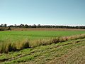
Paddocks along Waterford Tamborine Road, 2014
-
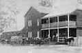
Logan Village Hotel, 1912
-
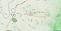
Location of the 1920s rifle range
-
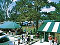
Settlers Day celebrations, 2013
-
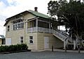
Old Logan Village State School, 2013
-
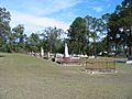
Logan Village Cemetery, 2005
-
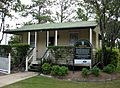
Col Ferguson Cottage, 2013
-
Doo Drop Inn


.jpg)
