
London Borough of Brent facts for kids
Quick facts for kids
London Borough of Brent
|
||
|---|---|---|
|
||
| Motto(s):
Forward Together
|
||

Brent shown within Greater London
|
||
| Sovereign state | United Kingdom | |
| Constituent country | England | |
| Region | London | |
| Ceremonial county | Greater London | |
| Created | 1 April 1965 | |
| Admin HQ | Engineers Way, Wembley | |
| Government | ||
| • Type | London borough council | |
| • Body | Brent London Borough Council | |
| Area | ||
| • Total | 16.70 sq mi (43.24 km2) | |
| Area rank | 284th (of 326) | |
| Population
(2020)
|
||
| • Total | 329,771 | |
| • Rank | 28th (of 326) | |
| • Density | 19,752.6/sq mi (7,626.5/km2) | |
| • Ethnicity | 18% White British 4% White Irish 0.1% White Gypsy or Irish Traveller 14.3% Other White 1.4% White & Black Caribbean 0.9% White & Black African 1.2% White & Asian 1.6% Other Mixed 18.6% Indian 4.6% Pakistani 0.6% Bangladeshi 1% Chinese 9.2% Other Asian 7.8% Black African 7.6% Black Caribbean 3.4% Other Black 3.7% Arab 2.1% Other |
|
| Time zone | UTC (GMT) | |
| • Summer (DST) | UTC+1 (BST) | |
| Postcodes |
HA, NW, W
|
|
| Area code(s) | 020 | |
| ONS code | 00AE | |
| GSS code | E09000005 | |
| Police | Metropolitan Police | |
| Website | http://www.brent.gov.uk | |

The London Borough of Brent is a London borough in north-west London. It borders the boroughs of Harrow to the north-west, Barnet to the north-east, Camden to the east, the City of Westminster to the south-east, as well as the Royal Borough of Kensington and Chelsea, Hammersmith and Fulham and Ealing to the south. Most of the eastern border is formed by the Roman road Watling Street, which is now the modern A5.
Brent's population is estimated to be 329,771. Major districts are Kilburn, Willesden and Wembley, while other districts include Harlesden, Stonebridge, Kingsbury and Queen's Park. Brent has a mixture of residential, industrial and commercial land. It includes many districts of inner-city character in the east and a more distinct suburban character in the west, part of which formed part of the early 20th century Metroland developments. Today Brent is known for being home to Wembley Stadium, the country's largest stadium by capacity, as well as other landmarks such as the Kiln Theatre, the Swaminarayan Temple and Wembley Arena. Other notable places are the Welsh Harp reservoir and the Park Royal commercial estate. The local authority is Brent London Borough Council.
Contents
History

Brent was formed in 1965 from the area of the former Municipal Borough of Wembley and Municipal Borough of Willesden of Middlesex. Its name derives from the River Brent which runs through the borough.
Demographics
| Population | ||
|---|---|---|
| Year | Pop. | ±% |
| 1801 | 2,022 | — |
| 1811 | 2,690 | +33.0% |
| 1821 | 3,074 | +14.3% |
| 1831 | 3,991 | +29.8% |
| 1841 | 5,416 | +35.7% |
| 1851 | 5,646 | +4.2% |
| 1861 | 14,749 | +161.2% |
| 1871 | 23,852 | +61.7% |
| 1881 | 32,955 | +38.2% |
| 1891 | 67,674 | +105.4% |
| 1901 | 105,613 | +56.1% |
| 1911 | 164,833 | +56.1% |
| 1921 | 202,448 | +22.8% |
| 1931 | 248,656 | +22.8% |
| 1941 | 277,842 | +11.7% |
| 1951 | 310,457 | +11.7% |
| 1961 | 294,804 | −5.0% |
| 1971 | 280,009 | −5.0% |
| 1981 | 251,249 | −10.3% |
| 1991 | 248,569 | −1.1% |
| 2001 | 263,463 | +6.0% |
| 2011 | 311,215 | +18.1% |
| Source: A Vision of Britain through time | ||
In 1801, the civil parishes that form the modern borough had a total population of 2,022. This rose slowly throughout the nineteenth century, as the district became built up; reaching 5,646 in the middle of the century. When the railways arrived the rate of population growth increased. The population took five decades to rebound to the more muted peak of the 1950s, when much industry relocated from London, further boosting the speed of the wave of new housing then built.
Brent is the most diverse locality in the UK by country of birth. It in 2019 became the only local authority with over 50% of residents, namely 52%, born abroad. Large Asian and Indian, Black African, Black Caribbean, Irish, and Eastern European communities exist. 45 percent of the population was a minority ethnicity in the 1991 census, the most in England at the time. In 1991 17.2% were Indian, 10.2% were Black Caribbean and 9% were Irish. Brent was the only Outer London borough combining high proportions of Indian and Afro-Caribbean ethnicities.
The 2001 UK Census found that the borough had a population of 263,464 residents, of whom 127,806 were male, and 135,658 female. Of those stating a choice, 47.71% described themselves as Christian, 17.71% as Hindu, 12.26% as Muslim and 10% as having no religion. Among residents, 39.96% were in full-time employment and 7.86% in part-time employment – compared to a London average of 42.64% and 8.62%, respectively. Narrowly most residents included an owner-occupier in their household, with 23.17% of households owning their house outright, and a further 31.33% owning with a mortgage. 10.59% were in local authority housing, with a further 13.29% renting from a housing association, or other registered social landlord.
The borough of Brent is extremely ethnically diverse, having changed greatly since 1951. In the 2011 census, those who identified as White British made up 18% of the borough's population. 18% identified as other White, 5% were of mixed heritage, those of South Asian heritage comprised about 33%, those of African and Caribbean heritage about 19%, and other ethnic groups about 7%. White ethnicities were relatively high in the wards of Mapesbury (straddling Willesden Green and Cricklewood), Brondesbury Park, Queen's Park and Kilburn. Black ethnicities in highest proportion were in Stonebridge, Harlesden and Kensal Green wards. Asian ethnicities in highest proportion were in the wards of Alperton, Wembley Central and Kenton. Those who ethnically identify as BAME (Black, Asian and minority Ethnic) was as high as 86% in Wembley Central – one of the highest in London – and most other Brent wards have a majority BAME population. Queen's Park had the lowest BAME proportion, at 37.0%.
Brent has the highest proportion of Irish residents in Britain, with 4% of the population. It also has the largest Brazilian community in the UK; one of the largest Indian communities; a significant Afro-Caribbean community; and more recent Romanian, Polish and Somali communities.
Religion
As of 2011, 41.5% identified themselves as Christian, 18.6% Muslim, 17.8% Hindu and 10.6% with no religion. Brent is notably home of the Neasden Temple, once the largest Hindu Mandir outside India; and JFS, the largest Jewish school in Europe. There is also an Islamic school called Islamia Primary School founded by Cat Stevens.
Ethnicity
This table shows the stated ethnic group of respondents of the 2001 and 2011 censuses in Brent.
| Ethnic Group | 2001 | 2011 | ||
|---|---|---|---|---|
| Number | % | Number | % | |
| White: British | 76,893 | 29.19% | 55,887 | 17.96% |
| White: Irish | 18,313 | 6.95% | 12,320 | 3.96% |
| White: Gypsy or Irish Traveller | 320 | 0.10% | ||
| White: Other | 24,072 | 9.14% | 44,353 | 14.25% |
| White: Total | 119,278 | 45.27% | 112,880 | 36.27% |
| Asian or Asian British: Indian | 48,624 | 18.46% | 58,017 | 18.64% |
| Asian or Asian British: Pakistani | 10,626 | 4.03% | 14,381 | 4.62% |
| Asian or Asian British: Bangladeshi | 1,184 | 0.45% | 1,749 | 0.56% |
| Asian or Asian British: Chinese | 2,812 | 1.07% | 3,250 | 1.04% |
| Asian or Asian British: Other Asian | 12,628 | 4.79% | 28,589 | 9.19% |
| Asian or Asian British: Total | 75,874 | 28.80% | 105,986 | 34.06% |
| Black or Black British: African | 20,640 | 7.83% | 24,391 | 7.84% |
| Black or Black British: Caribbean | 27,574 | 10.47% | 23,723 | 7.62% |
| Black or Black British: Other Black | 4,123 | 1.56% | 10,518 | 3.38% |
| Black or Black British: Total | 52,337 | 19.86% | 58,632 | 18.84% |
| Mixed: White and Black Caribbean | 2,739 | 1.04% | 4,291 | 1.38% |
| Mixed: White and Black African | 1,739 | 0.66% | 2,820 | 0.91% |
| Mixed: White and Asian | 2,529 | 0.96% | 3,642 | 1.17% |
| Mixed: Other Mixed | 2,795 | 1.06% | 5,022 | 1.61% |
| Mixed: Total | 9,802 | 3.72% | 15,775 | 5.07% |
| Other: Arab | 11,430 | 3.67% | ||
| Other: Any other ethnic group | 6,512 | 2.09% | ||
| Other: Total | 6,173 | 2.34% | 17,942 | 5.77% |
| Black, Asian, and minority ethnic: Total | 144,186 | 54.73% | 198,335 | 63.73% |
| Total | 263,464 | 100.00% | 311,215 | 100.00% |
Geography
Major districts of Brent include:Kilburn, Willesden and Wembley.
Climate
Climate in this area has mild differences between highs and lows, and there is adequate rainfall year round. The Köppen Climate Classification subtype for this climate is "Cfb". (Marine West Coast Climate/Oceanic climate).
| Climate data for Borough of Brent, UK | |||||||||||||
|---|---|---|---|---|---|---|---|---|---|---|---|---|---|
| Month | Jan | Feb | Mar | Apr | May | Jun | Jul | Aug | Sep | Oct | Nov | Dec | Year |
| Average high °C (°F) | 8 (46) |
8 (46) |
10 (50) |
12 (54) |
15 (59) |
17 (63) |
19 (66) |
19 (66) |
17 (63) |
14 (57) |
11 (52) |
8 (46) |
13 (55) |
| Average low °C (°F) | 3 (37) |
3 (37) |
4 (39) |
5 (41) |
8 (46) |
10 (50) |
12 (54) |
12 (54) |
10 (50) |
8 (46) |
6 (43) |
4 (39) |
7 (45) |
| Average precipitation mm (inches) | 130 (5.2) |
110 (4.3) |
79 (3.1) |
84 (3.3) |
79 (3.1) |
64 (2.5) |
76 (3) |
89 (3.5) |
89 (3.5) |
140 (5.7) |
150 (5.9) |
150 (6.1) |
1,250 (49.4) |
| Source: Weatherbase | |||||||||||||
Amenities and culture
Education
Compulsory recycling
Recycling has been compulsory in the borough of Brent since 2008. Through a green box collection scheme the borough aims to improve on the 25 per cent recycled waste it already achieves.
London Fire Brigade
The London Borough of Brent has three fire stations within the borough: Park Royal, Wembley and Willesden. Brent has a mixture of residential, industrial and commercial land. Most notably, Wembley National Stadium is within the area - on match days the safety of over 90,000 people is the responsibility of the London Fire Brigade. Wembley covers the largest area in the borough, 19.1 km2 (7.4 sq mi). Two pumping appliances, a fire rescue unit and an aerial ladder platform are based there. Willesden, for its relatively small, in comparison to Wembley, station ground (10.5 km2 (4.1 sq mi)), responded to over a thousand incidents in 2006/2007. Two pumping appliances reside there. Park Royal, with its one pumping appliance and an incident response unit, has one of the smallest station grounds; just 8.1 km2 (3.1 sq mi). Within the borough, 4,105 incidents occurred in 2006/2007.
Transport
The numerous London Underground, London Overground and National Rail stations in the borough are:
- Alperton tube station
- Brondesbury railway station
- Brondesbury Park railway station
- Dollis Hill tube station
- Harlesden station
- Kensal Green station
- Kenton station
- Kilburn tube station
- Kilburn Park tube station
- Kingsbury tube station
- Neasden tube station
- North Wembley station
- Northwick Park tube station
- Preston Road tube station
- Queensbury tube station
- Queen's Park station
- South Kenton station
- Stonebridge Park station
- Sudbury Town tube station
- Sudbury & Harrow Road railway station
- Wembley Central station
- Wembley Park tube station
- Wembley Stadium railway station
- Willesden Green tube station
- Willesden Junction station
Travel to work
In March 2011, the main forms of transport that residents used to travel to work were (of all residents aged 16–74):
- underground, metro, light rail, tram, 18.3%;
- driving a car or van, 11.5%;
- bus, minibus or coach, 11.5%;
- on foot, 4.6%;
- train, 4.5%;
- work mainly at or from home, 2.6%;
- bicycle, 1.7%.
Landmarks
- Wembley Stadium
- Wembley Arena
- Neasden Temple
- Jubilee clock Harlesden
- Brent Town Hall
Parks and open spaces
- Roe Green Park
- Queen's Park
- Roundwood Park
- Tiverton Green
- Gladstone Park
- Barham Park
- One Tree Hill Park
- Maybank Open Space
- King Edward VI Park
Sport and leisure
The Borough has three Non-League football clubs:
- Tokyngton Manor F.C., which plays at Spratleys Meadow.
- Wembley F.C., which plays at Vale Farm stadium
- South Kilburn F.C. which plays at Vale Farm stadium.
Town twinning
Brent is twinned with:
 South Dublin, Leinster, Ireland
| Greater London • London • City of London | |
|---|---|
|
London Boroughs: Barking and Dagenham • Barnet • Bexley • Brent • Bromley • Camden • Croydon • Ealing • Enfield • Greenwich • Hackney • Hammersmith and Fulham • Haringey • Harrow • Havering • Hillingdon • Hounslow • Islington • Kensington and Chelsea • Kingston • Lambeth • Lewisham • Merton • Newham • Redbridge • Richmond • Southwark • Sutton • Tower Hamlets • Waltham Forest • Wandsworth • Westminster |
|
Economy
Diageo has its head office in Park Royal and in the London Borough of Brent, on a former Guinness brewery property. The brewery was closed in 2004; it had produced beer since 1936. Diageo planned to move its head office to Brent from Central London when the lease on the Central London office expired in 2010.
Brent is the joint fourth-worst Borough in London for levels of child poverty. Save the Children reported in 2011 that 11,000 children are impoverished.
Images for kids
-
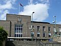
The old Brent Town Hall
-
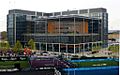
The new Brent Civic Centre
,_Wembley_-_geograph.org.uk_-_865102.jpg)
.jpg)
See also
 In Spanish: Brent (Londres) para niños
