
London station group facts for kids
The London station group is a group of 18 railway stations in central London. They are part of the National Rail network. Most are terminal stations, meaning that they are at the end of the railway line. The station group is shown on tickets as London Terminals.
Group members
As of 2024, the group is made up of:
Former members
- Broad Street (closed 1986)
- Holborn Viaduct (closed 1990)
- Kensington Olympia (withdrawn 1994)
- Kings Cross Thameslink (closed 2007)
Station statistics
| Station | Image | Location | Coordinates | Managed by | London services | National services | Annual entry/exit (millions) 2006/7 |
Annual entry/exit (millions) 2007/8 |
Annual entry/exit (millions) 2008/9 |
Annual entry/exit (millions) 2009/10 |
Open date |
Terminal platforms |
Through platforms |
|---|---|---|---|---|---|---|---|---|---|---|---|---|---|
| Blackfriars |  |
City of London | 51°30′40″N 0°06′11″W / 51.511°N 0.103°W | First Capital Connect | NW, N, S, SE | Thameslink, Gatwick Airport, Luton Airport | 1886 | 2 | 2 | ||||
| Cannon Street | City of London | 51°30′36″N 0°05′24″W / 51.510°N 0.090°W | Network Rail | SE | Kent and East Sussex | 1866 | 7 | 0 | |||||
| Charing Cross |  |
Westminster | 51°30′25″N 0°07′23″W / 51.507°N 0.123°W | Network Rail | SE | Kent and East Sussex | 1864 | 6 | 0 | ||||
| City Thameslink |  |
City of London | 51°30′58″N 0°06′11″W / 51.516°N 0.103°W | First Capital Connect | NW, N, S, SE | Thameslink, Gatwick Airport, Luton Airport | 1988 | 0 | 2 | ||||
| Euston |  |
Camden | 51°31′41″N 0°07′59″W / 51.528°N 0.133°W | Network Rail | NW | West Coast Main Line | 1837 | 18 | 0 | ||||
| Fenchurch Street |  |
City of London | 51°30′40″N 0°04′41″W / 51.511°N 0.078°W | Network Rail | E | Southend-on-Sea | 1841 | 4 | 0 | ||||
| Kings Cross |  |
Camden | 51°31′55″N 0°07′23″W / 51.532°N 0.123°W | Network Rail | N | East Coast Main Line | 1852 | 12 | 0 | ||||
| Liverpool Street |  |
City of London | 51°31′05″N 0°04′52″W / 51.518°N 0.081°W | Network Rail | E, NE | East of England, Stansted Airport | 1874 | 18 | 0 | ||||
| London Bridge |  |
Southwark | 51°30′18″N 0°05′10″W / 51.505°N 0.086°W | Network Rail | S, SE, NW | Kent, East Sussex, Gatwick Airport | 1836 | 9 | 6 | ||||
| Marylebone |  |
Westminster | 51°31′19″N 0°09′47″W / 51.522°N 0.163°W | Chiltern Railways | NW | Birmingham | 1899 | 6 | 0 | ||||
| Moorgate |  |
City of London | 51°31′05″N 0°05′17″W / 51.518°N 0.088°W | London Underground | N | Hertfordshire | 1865 | 2 | 0 | ||||
| Old Street |  |
Islington | 51°31′30″N 0°05′13″W / 51.525°N 0.087°W | London Underground | N | Hertfordshire | 0.734 | 1901 | 0 | 2 | |||
| Paddington |  |
Westminster | 51°31′01″N 0°10′37″W / 51.517°N 0.177°W | Network Rail | W | Great Western Main Line, Heathrow Airport | 1854 | 14 | 0 | ||||
| St Pancras |  |
Camden | 51°31′48″N 0°07′30″W / 51.530°N 0.125°W | Network Rail | N, NW, S, SE | Midland Main Line, Gatwick Airport, Luton Airport, Kent | 1868 | 13 | 2 | ||||
| Vauxhall |  |
Lambeth | 51°29′06″N 0°07′19″W / 51.485°N 0.122°W | South West Trains | SW | South West England | 1848 | 0 | 10 | ||||
| Victoria |  |
Westminster | 51°29′46″N 0°08′38″W / 51.496°N 0.144°W | Network Rail | S, SE, SW | Kent, Sussex, Gatwick Airport | 1862 | 19 | 0 | ||||
| Waterloo |  |
Lambeth | 51°30′11″N 0°06′47″W / 51.503°N 0.113°W | Network Rail | SW | South West England | 1848 | 19 | 0 | ||||
| Waterloo East |  |
Lambeth | 51°30′14″N 0°06′36″W / 51.504°N 0.110°W | Southeastern | S, SE | Kent and East Sussex | 1869 | 0 | 4 |
Related pages
Images for kids
-
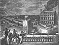
The first London terminal station, London Bridge, in 1836
-
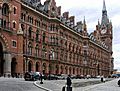
The distinctive Gothic architecture of St Pancras railway station survived demolition, unlike neighbouring Euston.
-
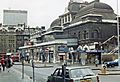
Broad Street station was one of the few in the London station group to be closed and demolished.
-
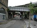
The building of railway lines into London took up a substantial amount of land, particularly south of the Thames.


_-_geograph.org.uk_-_470890.jpg)

All content from Kiddle encyclopedia articles (including the article images and facts) can be freely used under Attribution-ShareAlike license, unless stated otherwise. Cite this article:
London station group Facts for Kids. Kiddle Encyclopedia.