
Longlands facts for kids
Quick facts for kids Longlands |
|
|---|---|

Longlands
|
|
| Population | 10,442 (2011 Census. Ward) |
| OS grid reference | TQ449722 |
| London borough | |
| Ceremonial county | Greater London |
| Region | |
| Country | England |
| Sovereign state | United Kingdom |
| Post town | SIDCUP |
| Postcode district | DA14, DA15 |
| Post town | LONDON |
| Postcode district | SE9 |
| Post town | CHISLEHURST |
| Postcode district | BR7 |
| Dialling code | 020 |
| Police | Metropolitan |
| Fire | London |
| Ambulance | London |
| EU Parliament | London |
| UK Parliament |
|
| London Assembly |
|

Longlands is an area of South East London overlapping the London Boroughs of Bexley, Bromley and Greenwich. It lies north west of Sidcup and south east of Eltham.
Some old maps and records have the name as two words "Long Lands", and show it was in the Foots Cray/Sidcup parish in the Hundred of Ruxley.
Found within Longlands
On Main Road there are a small number of shops including a Peugeot show room, an off license/convenience store, a fish and chip shop, a restaurant, a launderette and a small post office. Shops here seem to be somewhat over shadowed by nearby larger towns, New Eltham and especially Sidcup. Within Longlands the place gives it name to Longlands Recreation Ground, Longlands Primary School, Longlands Road and Longlands Park Crescent. Also things found within the ward of Longlands include Queen Mary's Hospital, Frognal Corner Roundabout, Sidcup Fire Station, Sidcup Place, two primary schools, Longlands primary school and Dulverton Primary School, one secondary school, St Mary and St Joseph's Catholic School, and a small college. These are all part of the Sidcup post town, with the exception of Dulverton Primary School which occupies the small westerly part of the ward that overlaps into the SE9postcode district, that is within the London post town.The small river Wyncham Stream also flows from Chislehurst northward through Longlands toward Lamorbey and finally into the River Shuttle.
Transport
Rail
The closest National Rail stations to Longlands is New Eltham and Sidcup.
Buses
Longlands is served by two Transport for London bus services.
- 233 to Eltham and to Swanley via Sidcup
- 321 to New Cross via Eltham and Lewisham and to Foots Cray via Sidcup (24 Hour Service)
Images for kids
-
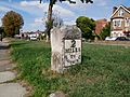
An 18th-century milestone, now Grade II listed, along Footscray Road in Longlands
.jpg)
