Lordstown, Ohio facts for kids
Quick facts for kids
Lordstown, Ohio
|
|
|---|---|
|
Village
|
|
| Village of Lordstown | |

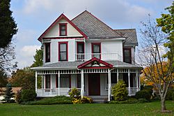
The Almon G. McCorkle House, a historic site in the village
|
|

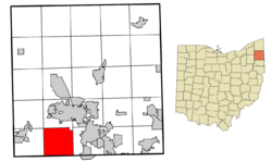
Location of Lordstown in Trumbull County within the state of Ohio
|
|
| Country | United States |
| State | Ohio |
| County | Trumbull |
| Area | |
| • Total | 23.20 sq mi (60.08 km2) |
| • Land | 23.19 sq mi (60.07 km2) |
| • Water | 0.00 sq mi (0.01 km2) |
| Elevation | 951 ft (290 m) |
| Population
(2010)
|
|
| • Total | 3,417 |
| • Estimate
(2019)
|
3,258 |
| • Density | 140.47/sq mi (54.24/km2) |
| Time zone | UTC-5 (Eastern (EST)) |
| • Summer (DST) | UTC-4 (EDT) |
| ZIP code |
44481
|
| Area code(s) | 234/330 |
| FIPS code | 39-44912 |
| GNIS feature ID | 1061443 |
Lordstown is a village in Trumbull County, Ohio, United States. It is part of the Youngstown-Warren-Boardman, OH-PA Metropolitan Statistical Area.
Contents
Geography
Lordstown is located at 41°10′18″N 80°52′00″W / 41.17167°N 80.86667°W (41.171785, -80.866655). It borders or touches the following other townships and municipalities:
- Jackson Township, Mahoning County, on the south;
- Milton Township, Mahoning County, on the southwest (touches, but does not border);
- Newton Township, on the west;
- Braceville Township, on the northwest (touches, but does not border);
- Warren Township, on the north;
- Weathersfield Township, on the east;
- Austintown Township, Mahoning County, on the southeast (touches, but does not border);
According to the United States Census Bureau, the village has a total area of 23.14 square miles (59.93 km2), all land.
Demographics
| Historical population | |||
|---|---|---|---|
| Census | Pop. | %± | |
| 1980 | 3,280 | — | |
| 1990 | 3,404 | 3.8% | |
| 2000 | 3,633 | 6.7% | |
| 2010 | 3,417 | −5.9% | |
| 2019 (est.) | 3,258 | −4.7% | |
| U.S. Decennial Census | |||
2010 census
As of the census of 2010, there were 3,417 people, 1,391 households, and 1,025 families living in the village. The population density was 147.7 inhabitants per square mile (57.0/km2). There were 1,496 housing units at an average density of 64.6 per square mile (24.9/km2). The racial makeup of the village was 95.1% White, 3.2% African American, 0.1% Native American, 0.4% Asian, 0.1% from other races, and 1.1% from two or more races. Hispanic or Latino of any race were 0.9% of the population.
There were 1,391 households, of which 29.5% had children under the age of 18 living with them, 58.0% were married couples living together, 10.2% had a female householder with no husband present, 5.5% had a male householder with no wife present, and 26.3% were non-families. 22.1% of all households were made up of individuals, and 9.9% had someone living alone who was 65 years of age or older. The average household size was 2.46 and the average family size was 2.86.
The median age in the village was 45 years. 21.1% of residents were under the age of 18; 6.3% were between the ages of 18 and 24; 22.7% were from 25 to 44; 32.7% were from 45 to 64; and 17.2% were 65 years of age or older. The gender makeup of the village was 48.6% male and 51.4% female.
Education
Lordstown Local School District operates one elementary school and Lordstown High School.
Lordstown has a public library, a branch of the Warren-Trumbull County Public Library.
See also
 In Spanish: Lordstown (Ohio) para niños

