
Los Altos Hills, California facts for kids
Quick facts for kids
Town of Los Altos Hills
|
||
|---|---|---|

Westwind Community Barn
|
||
|
|
||

Location in Santa Clara County and the state of California
|
||

Los Altos Hills, California
Location in California

Los Altos Hills, California
Location in the United States
|
||
| Country | United States | |
| State | California | |
| County | Santa Clara | |
| Incorporated | January 27, 1956 | |
| Area | ||
| • Total | 9.03 sq mi (23.38 km2) | |
| • Land | 9.03 sq mi (23.38 km2) | |
| • Water | 0.00 sq mi (0.00 km2) 0% | |
| Elevation | 292 ft (89 m) | |
| Population
(2020)
|
||
| • Total | 8,489 | |
| • Density | 940.1/sq mi (363.09/km2) | |
| Time zone | UTC-8 (PST) | |
| • Summer (DST) | UTC-7 (PDT) | |
| ZIP codes |
94022, 94024
|
|
| Area code(s) | 650 | |
| FIPS code | 06-43294 | |
| GNIS feature ID | 1659746 | |
| Website | http://www.losaltoshills.ca.gov/ | |
Los Altos Hills ( Los Altos, Spanish for "The Heights") is an incorporated town in Santa Clara County, California, United States. The population was 8,489 at the 2020 census. The town is known for its affluence and expensive residential real estate.
Contents
Strictly residential
Los Altos Hills has a ban on commercial zones, which was upheld by the California Court of Appeal (First District) in 1973. The town's only retail commercial operation is the book store on the campus of Foothill College. The town does not have a post office or library, with mail delivery provided from nearby Los Altos.
The town's zoning regulations require a minimum lot size of one acre (4,000 m²), setbacks from the property boundary, and easements for public pathways. Landowners are limited to one primary dwelling per lot, which effectively bans multifamily housing; this ban and the minimum lot size were upheld as constitutional by the U.S. Court of Appeals for the Ninth Circuit in 1974.
The town government contracts with Santa Clara County for police and fire services, making it a so-called "contract city" under California law.
The town is home to a convent of the Daughters of Charity of St. Vincent de Paul.
Geography
Los Altos Hills is located at 37°22′17″N 122°8′15″W / 37.37139°N 122.13750°W (37.371390, -122.137605).
According to the United States Census Bureau, the town has a total area of 8.8 square miles (23 km2), all of it land.
The town is located in a group of small hills. Both the Altamont and Monte Vista Faults pass through the town.
Demographics
| Historical population | |||
|---|---|---|---|
| Census | Pop. | %± | |
| 1960 | 3,412 | — | |
| 1970 | 6,871 | 101.4% | |
| 1980 | 7,421 | 8.0% | |
| 1990 | 7,514 | 1.3% | |
| 2000 | 7,902 | 5.2% | |
| 2010 | 7,922 | 0.3% | |
| 2020 | 8,489 | 7.2% | |
| U.S. Decennial Census | |||
2010
At the 2010 census Los Altos Hills had a population of 7,922. The population density was 900.0 people per square mile (347.5/km2). The racial makeup of Los Altos Hills was 5,417 (68.4%) White, 37 (0.5%) African American, 4 (0.1%) Native American, 2,109 (26.6%) Asian, 8 (0.1%) Pacific Islander, 50 (0.6%) from other races, and 297 (3.7%) from two or more races. Hispanic or Latino of any race were 213 people (2.7%).
The census reported that 99.3% of the population lived in households and 0.7% lived in non-institutionalized group quarters.
There were 2,829 households, 949 (33.5%) had children under the age of 18 living in them, 2,204 (77.9%) were opposite-sex married couples living together, 114 (4.0%) had a female householder with no husband present, 53 (1.9%) had a male householder with no wife present. There were 53 (1.9%) unmarried opposite-sex partnerships, and 19 (0.7%) same-sex married couples or partnerships. 359 households (12.7%) were one person and 210 (7.4%) had someone living alone who was 65 or older. The average household size was 2.78. There were 2,371 families (83.8% of households); the average family size was 3.02.
The age distribution was 1,811 people (22.9%) under the age of 18, 342 people (4.3%) aged 18 to 24, 1,083 people (13.7%) aged 25 to 44, 2,848 people (36.0%) aged 45 to 64, and 1,838 people (23.2%) who were 65 or older. The median age was 50.2 years. For every 100 females, there were 97.8 males. For every 100 females age 18 and over, there were 96.4 males.
There were 3,001 housing units at an average density of 341.0 per square mile, of the occupied units 2,582 (91.3%) were owner-occupied and 247 (8.7%) were rented. The homeowner vacancy rate was 1.2%; the rental vacancy rate was 4.2%. 7,162 people (90.4% of the population) lived in owner-occupied housing units and 707 people (8.9%) lived in rental housing units.
The median household income was $219,485 and the median family income was $224,922. Males had a median income of $152,361 versus $89,216 for females. The per capita income for the town was $118,779. About 2.2% of families and 2.6% of the population were below the poverty line, including 0.7% of those under age 18 and 3.8% of those age 65 or over.
2000
At the 2000 census there were 7,902 people, 2,740 households, and 2,339 families in the town. The population density was 917.2 people per square mile (353.9/km2). There were 2,816 housing units at an average density of 326.9 per square mile (126.1/km2). The racial makeup of the town was 74.94% White, 21.10% Asian, 0.59% African American, 0.09% Native American, 0.09% Pacific Islander, 0.46% from other races, and 2.73% from two or more races. Hispanic or Latino of any race were 2.15%.
Of the 2,740 households 34.6% had children under the age of 18 living with them, 79.0% were married couples living together, 4.4% had a female householder with no husband present, and 14.6% were non-families. 10.5% of households were one person and 4.9% were one person aged 65 or older. The average household size was 2.86 and the average family size was 3.02.
The age distribution was 23.6% under the age of 18, 4.0% from 18 to 24, 19.6% from 25 to 44, 35.8% from 45 to 64, and 17.0% 65 or older. The median age was 47 years. For every 100 females, there were 97.4 males. For every 100 females age 18 and over, there were 94.2 males.
The median household income was $143,570 and the median family income was $161,865. Males had a median income of $200,000+ versus $178,288 for females. The per capita income for the town was $92,840. About 1.2% of families and 1.9% of the population were below the poverty line, including 2.5% of those under age 18 and 2.0% of those age 65 or over.
Gallery
-
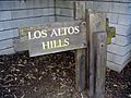
Standard entrance sign.
-
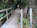
A typical off-road pathway in Los Altos Hills.
-
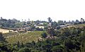
The 60 acre Packard orchard (now owned by the David and Lucile Salter Packard Foundation).
-
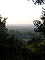
Los Altos Hills in the twilight.


- Los Altos Town Crier – city newspaper
Education
Los Altos Hills is served by both the Palo Alto Unified School District (serving the northern part of the town) and the Los Altos School District (serving the southern part of the town). In 2008 the Los Altos School District reopened Gardner Bullis School, a public elementary (K-6) grade school in Los Altos Hills.
Ventana School is a private pre-school and elementary school modeled around the Reggio Emilia approach. Pinewood is a private coeducational K-12 school. The Pinewood School Upper Campus is also located in Los Altos Hills, serving students in grades 7-12.
Foothill College operated by the Foothill–De Anza Community College District is in the city. The college has the district's headquarters.
Notable residents

- Adrienne Barbeau
- Barry Bonds, baseball player
- Sergey Brin, co-founder of Google
- John T. Chambers
- Jon M. Chu and his father "Chef Chu" Lawrence Chu
- Steve Kirsch
- George M. Marcus (born 1941/42), billionaire real estate broker, founder of Marcus & Millichap
- Yuri Milner
- Gordon Moore
- Becky Morgan (politician)
- David Packard
- Sundar Pichai
- Frank Quattrone
- Stephen Schott
- Wallace Stegner
- Max Thieriot, actor and director
- Jed York
- Jerry Yang
- Connie Young Yu
See also
 In Spanish: Los Altos Hills para niños
