
Los Angeles County facts for kids
Quick facts for kids
Los Angeles County
|
|
|---|---|

Location within the U.S. state of California
|
|
 California's location within the U.S. |
|
| Country | |
| State | |
| Founded | 1850 |
| Named for | Los Angeles, California |
| Seat | Los Angeles |
| Area | |
| • Total | 4,752 sq mi (12,310 km2) |
| • Land | 4,061 sq mi (10,520 km2) |
| • Water | 691 sq mi (1,790 km2) 14.55%% |
| Population
(2006)
|
|
| • Total | 9,948,081 (est) |
| • Density | 2,450/sq mi (946/km2) |
Los Angeles County is a county in California and is by far the most populous county in the United States. Figures from the U.S. Census Bureau give an estimated 2006 population of 9,948,081 residents, while the California State government's population bureau lists a January 1 2007 estimate of 10,331,939. The county seat is the City of Los Angeles.
Contents
History

Los Angeles County is one of the original counties of California, created at the time of statehood in 1850. The county originally included parts of what are now Kern, San Bernardino, Riverside and Orange counties. In 1851 and 1852, Los Angeles County strechted from the coast to the border of Nevada. As the population increased, sections were split off to organize San Bernardino County in 1853, Kern County in 1866, and Orange County in 1889.
Geography

According to the U.S. Census Bureau, the county has an area of 4,751 square miles (12,310 km2), of which 4,058 square miles (10,510 km2) is land and 693 square miles (1,790 km2) (15%) is water. Los Angeles County borders 70 miles (110 km) of coast on the Pacific Ocean and encompasses mountain ranges, valleys, forests, islands, lakes, rivers, and desert. The Los Angeles River, Rio Hondo, the San Gabriel River and the Santa Clara River flow in Los Angeles County, while the primary mountain ranges are the Santa Monica Mountains and the San Gabriel Mountains. The western extent of the Mojave Desert begins in the Antelope Valley, in the northeastern part of the county.

Most of the population of Los Angeles County is located in the south and southwest, with major population centers in the Los Angeles Basin, San Fernando Valley and San Gabriel Valley. Other population centers are found in the Santa Clarita Valley, Pomona Valley, Crescenta Valley and Antelope Valley.
The county is divided west-to-east by the San Gabriel Mountains, which are part of the Transverse Ranges of southern California, and are contained mostly within the Angeles National Forest. Most of the county's highest peaks are in the San Gabriel Mountains, including Mount San Antonio 10,068 feet (3,069 m)) at the Los Angeles-San Bernardino county lines, Mount Baden-Powell 9,399 feet (2,865 m), Mount Burnham 8,997 feet (2,742 m) and Mount Wilson 5,710 feet (1,740 m). Several lower mountains are in the northern, western, and southwestern parts of the county, including the San Emigdio Mountains, the southernmost part of Tehachapi Mountains and the Sierra Pelona Mountains.
Los Angeles County includes San Clemente Island and Santa Catalina Island, which are part of the Channel Islands archipelago off the Pacific Coast.
Lakes and reservoirs
- Baldwin Lake
- Bouquet Reservoir
- Castaic Lake
- Crystal Lake
- Elizabeth Lake
- Holiday Lake
- Hollywood Reservoir
- Hughes Lake
- Jackson Lake
- Malibou Lake
- Morris Reservoir
- Munz Lakes
- Lake Palmdale
- Puddingstone Reservoir
- Pyramid Lake
- Quail Lake
- Silver Lake Reservoir
- Stone Canyon Reservoir
- Tweedy Lake
Economy
.svg)
Los Angeles County is commonly associated with the entertainment and digital media industry; all six major film studios—Paramount Pictures, 21st Century Fox, Sony, Warner Bros., Universal Pictures, and Walt Disney Studios—are located within the county. Numerous other major industries also define the economy of Los Angeles County, including international trade supported by the Port of Los Angeles and the Port of Long Beach, music recording and production, aerospace and defense, fashion, and professional services such as law, medicine, engineering and design services, financial services and more. High-tech sector employment within Los Angeles County is 368,500 workers, and manufacturing employment within Los Angeles County is 365,000 workers.
The following major companies have headquarters in Los Angeles County:
|
|
|
Sites of interest


The county's most visited park is Griffith Park, owned by the city of Los Angeles. The county is also known for the annual Rose Parade in Pasadena, the annual Los Angeles County Fair in Pomona, the Los Angeles County Museum of Art, the Los Angeles Zoo, the Natural History Museum of Los Angeles County, the La Brea Tar Pits, the Arboretum of Los Angeles, and two horse racetracks and two car racetracks (Pomona Raceway and Irwindale Speedway), also the RMS Queen Mary located in Long Beach, and the Long Beach Grand Prix, and miles of beaches—from Zuma to Cabrillo.
Venice Beach is a popular attraction where its Muscle Beach used to find throngs of tourists admiring "hardbodies". Today, it is more arts-centered. Santa Monica's pier is a well known tourist spot, famous for its ferris wheel and bumper car rides, which were featured in the introductory segment of the television sitcom Three's Company. Further north in Pacific Palisades one finds the beaches used in the television series Baywatch. The fabled Malibu, home of many a film or television star, lies west of it.
In the mountain, canyon, and desert areas one may find Vasquez Rocks Natural Area Park, where many old Westerns were filmed. Mount Wilson Observatory in the San Gabriel Mountains is open for the public to view astronomical stars from its telescope, now computer-assisted. Many county residents find relaxation in water skiing and swimming at Castaic Lake Recreation Area – the county's largest park by area – as well as enjoying natural surroundings and starry nights at Saddleback Butte State Park in the eastern Antelope Valley – California State Parks' largest in area within the county. The California Poppy Reserve is located in the western Antelope Valley and shows off the State's flower in great quantity on its rolling hills every spring.
Transportation
Air
.jpg)
Los Angeles International Airport (LAX), located in the Westchester district, is the primary commercial airport for commercial airlines in the county and the Greater Los Angeles Area. LAX is operated by Los Angeles World Airports (LAWA), an agency of the City of Los Angeles.
Other important commercial airports in Los Angeles County include:
- Long Beach Municipal Airport operated by the City of Long Beach.
- Bob Hope Airport in Burbank, operated by the Burbank-Glendale-Pasadena Airport Authority.
The following general aviation airports also are located in Los Angeles County:
- County operated airports (Department of Public Works, Aviation Division)
- City operated airports
- Van Nuys Airport in Van Nuys, also operated by LAWA. Van Nuys Airport sees significant executive jet air traffic.
- LA/Palmdale Regional Airport in Palmdale. The airport is a separate facility on the grounds of Air Force Plant 42.
- Santa Monica Airport in Santa Monica, which has major executive jet traffic.
- Hawthorne Municipal Airport, also known as Jack Northrop Field, in Hawthorne.
- Zamperini Field in Torrance.
The U.S. Air Force operates three airports in Los Angeles County:
- Portions of Edwards Air Force Base, located at the northern edge of the county.
- Air Force Plant 42 in Palmdale, sharing runways with LA/Palmdale Regional.
- The non-flying Los Angeles Air Force Base in El Segundo.
Rail
Los Angeles is a major freight-railroad transportation center, largely due to the large volumes of freight moving in and out of the county's sea port facilities. The ports are connected to the downtown rail yards and to the main lines of Union Pacific and Burlington Northern Santa Fe headed east via a grade-separated, freight rail corridor known as the Alameda Corridor.
Passenger rail service is provided in the county by Amtrak, Los Angeles Metro Rail and Metrolink.
Amtrak has the following intercity Amtrak service at Union Station in the city of Los Angeles:
- The Pacific Surfliner to Santa Barbara, San Luis Obispo, and San Diego.
- The Coast Starlight to Seattle.
- The Southwest Chief to Chicago.
- The Sunset Limited to New Orleans and Orlando.
Union Station is also the primary hub for Metrolink commuter rail, which serves much of the Greater Los Angeles Area.
Light rail, subway (heavy rail), and long-distance bus service are all provided by the Los Angeles County Metropolitan Transportation Authority (Metro).
Sea
The county's two main seaports are the Port of Los Angeles and the Port of Long Beach. Together they handle over a quarter of all container traffic entering the United States, making the complex the largest and most important port in the country, and the third-largest port in the world by shipping volume.
The Port of Los Angeles is the largest cruise ship center on the West Coast, handling more than 1 million passengers annually.
The Port of Long Beach is home to the Sea Launch program, which uses a floating launch platform to insert payloads into orbits that would be difficult to attain from existing land-based launch sites.
Ferries link the Catalina Island city of Avalon to the mainland.
Images for kids
-
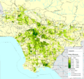
Partial map of Los Angeles County showing population density in 2000 by census tract
-
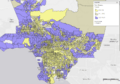
Percent of households with incomes above $150k across LA County census tracts.
-

Many introduced species, such as this Indian peafowl, adapt readily to urban living and Los Angeles County’s mild climate
-
Photo of the Los Angeles County Museum of Art during its 2005 Ancient Egypt exhibit.


.jpg)


See also
 In Spanish: Condado de Los Ángeles para niños
