
Lowell, Massachusetts facts for kids
Quick facts for kids
Lowell, Massachusetts
|
|||
|---|---|---|---|
| City of Lowell | |||
 ,_Lowell,_Massachusetts.JPG)   Left-right from top: Lowell City Hall, Lowell mills, University of Massachusetts Lowell, Lowell Skyline
|
|||
|
|||
| Nickname(s):
Mill City, Spindle City, City of Lights City of Magic
|
|||
| Motto(s):
"Art is the Handmaid of Human Good."
|
|||

Location in Middlesex County in Massachusetts
|
|||

Lowell, Massachusetts
Location in Massachusetts

Lowell, Massachusetts
Location in the United States
|
|||
| Country | |||
| State | |||
| County | Middlesex | ||
| Region | New England | ||
| Settled | 1652 | ||
| Incorporated | 1826 | ||
| A city | 1836 | ||
| Government | |||
| • Type | Manager-City council | ||
| Area | |||
| • Total | 14.53 sq mi (37.63 km2) | ||
| • Land | 13.61 sq mi (35.25 km2) | ||
| • Water | 0.92 sq mi (2.38 km2) | ||
| Elevation | 102 ft (31 m) | ||
| Population
(2020)
|
|||
| • Total | 115,554 | ||
| • Density | 8,490.37/sq mi (3,278.13/km2) | ||
| • Demonym | Lowellian | ||
| Time zone | UTC−5 (Eastern) | ||
| • Summer (DST) | UTC−4 (Eastern) | ||
| ZIP code |
01850, 01851, 01852, 01853, 01854
|
||
| Area code(s) | 978 / 351 | ||
| FIPS code | 25-37000 | ||
| GNIS feature ID | 0611832 | ||
| Website | City of Lowell, Massachusetts | ||


Lowell is a city in Massachusetts, in the United States. With Cambridge, Lowell is one of two traditional seats of Middlesex County. With an estimated population of 115,554 in 2020, it was the fifth most populous city in Massachusetts as of the last census, and the third most populous in the Boston metropolitan statistical area. The city also is part of a smaller Massachusetts statistical area, called Greater Lowell, and of New England's Merrimack Valley region.
Incorporated in 1826 to serve as a mill town, Lowell was named after Francis Cabot Lowell, a local figure in the Industrial Revolution. The city became known as the cradle of the American Industrial Revolution because of its textile mills and factories. Many of Lowell's historic manufacturing sites were later preserved by the National Park Service to create Lowell National Historical Park. During the Cambodian genocide (1975–1979), the city took in an influx of refugees, leading to a Cambodia Town and America's second largest Cambodian-American population.
Lowell is home to two institutions of higher education. UMass Lowell, part of the University of Massachusetts system, has three campuses in the city. Middlesex Community College's two campuses are in Lowell and in the town of Bedford, Massachusetts. Arts facilities in the city include the Whistler House Museum of Art, the Merrimack Repertory Theatre, the Lowell Memorial Auditorium, and Sampas Pavilion. In sports, the city has a long tradition of boxing, hosting the annual New England Golden Gloves boxing tournament. The city has a baseball stadium, Edward A. LeLacheur Park, and a multipurpose indoor sports arena, the Tsongas Center, both of which have hosted collegiate and minor-league professional sports teams.
Contents
History

Founded in the 1820s as a planned manufacturing center for textiles, Lowell is located along the rapids of the Merrimack River, 25 miles northwest of Boston in what was once the farming community of East Chelmsford, Massachusetts. The so-called Boston Associates, including Nathan Appleton and Patrick Tracy Jackson of the Boston Manufacturing Company, named the new mill town after their visionary leader, Francis Cabot Lowell, who had died five years before its 1823 incorporation. As Lowell's population grew, it acquired land from neighboring towns, and diversified into a full-fledged urban center. Many of the men who composed the labor force for constructing the canals and factories had immigrated from Ireland, escaping the poverty and Potato Famines of the 1830s and 1840s. The mill workers, young single women called Mill Girls, generally came from the farm families of New England.
_side;_2011-08-20.JPG)
By the 1850s, Lowell had the largest industrial complex in the United States. The textile industry wove cotton produced in the South. In 1860, there were more cotton spindles in Lowell than in all eleven states combined that would form the Confederacy. Yet the city did not simply finish raw materials produced in the American South, but rather became involved in the South in another way, too. Many of the coarse cottons produced in Lowell eventually returned to the South to clothe enslaved people, and, according to historian Sven Beckert, "'Lowell' became the generic term slaves used to describe coarse cottons." The city continued to thrive as a major industrial center during the 19th century, attracting more migrant workers and immigrants to its mills. Next were the Catholic Germans, followed by a large influx of French Canadians during the 1870s and 1880s. Later waves of immigrants included Portuguese, Polish, Lithuanians, Swedes, Greeks, and eastern European Jews. They came to work in Lowell and settled in ethnic neighborhoods, with the city's population reaching almost 50% foreign-born by 1900. By the time World War I broke out in Europe, the city had reached its economic and population peak of over 110,000 people.
In 1885 was founded the Lowell Co-operative Bank, today Sage Bank, one of the oldest still functioning banks in Massachusetts.
The Mill Cities' manufacturing base declined as companies began to relocate to the South in the 1920s. The city fell into hard times, and was even referred to as a "depressed industrial desert" by Harper's Magazine in 1931, as the Great Depression worsened. At this time, more than one-third of its population was "on relief", as only three of its major textile corporations remained active. Several years later, the mills were reactivated, making parachutes and other military necessities for the World War II effort. However, this economic boost was short-lived and the post-war years saw the last textile plants close.

In the 1970s, Lowell became part of the Massachusetts Miracle, being the headquarters of Wang Laboratories. At the same time, Lowell became home to thousands of new immigrants, many from Cambodia, following the genocide at the hands of the Khmer Rouge. The city continued to rebound, but this time, focusing more on culture. The former mill district along the river was partially restored and became part of the Lowell National Historical Park, founded in the late 1970s.

At this same time, the Lowell City Development Authority created a Comprehensive Master Plan which included recommendations for zoning adaptations within the city. The city's original zoning code was adopted in 1926 and was significantly revised in 1966 and 2004, with changes included to respond to concerns about overdevelopment.
Although Wang went bankrupt in 1992, the city continued its cultural focus by hosting the nation's largest free folk festival, the Lowell Folk Festival, as well as many other cultural events. This effort began to attract other companies and families back to the urban center. Additional historic manufacturing and commercial buildings were adapted as residential units and office space. By the 1990s, Lowell had built a new ballpark and arena, which became home to two minor league sports teams, the Lowell Devils and Lowell Spinners. The city also began to have a larger student population. The University of Massachusetts Lowell and Middlesex Community College expanded their programs and enrollment.
In 2002, in lieu of updating the Comprehensive Master Plan, more broad changes were recommended so that the land use and development would be consistent with the current master plan. The most significant revision to the 1966 zoning code is the adoption of an inclusion of a transect-based zoning code and some aspects of a form-based code style of zoning that emphasizes urban design elements as a means to ensure that infill development will respect the character of the neighborhood or district in question. By 2004, the recommended zoning changes were unanimously adopted by the City Council and despite numerous changes to the 2004 Zoning Code, it remains the basic framework for resolving zoning issues in Lowell to this day.

The Hamilton Canal District (HCD) is the first district in Lowell in which regulation and development is defined by Form-Based Code (HCD-FBC) and legislated by its own guiding framework consistent to the HCD Master Plan. The HCD is a major redevelopment project that comprises 13-acres of vacant, underutilized land in downtown Lowell abutting former industrial mills. Trinity Financial was elected as the Master Developer to recreate this district with a vision of making a mixed-use neighborhood. Development plans included establishing the HCD as a gateway to downtown Lowell and enhanced connectivity to Gallagher Terminal.
In July 2012, Lowell youth led a nationally reported campaign to gain voting privileges for 17-year-olds in local elections; it would have been the first municipality to do so. The 'Vote 17' campaign was supported by national researchers; its goals were to increase voter turnout, create lifelong civic habits, and increase youth input in local matters. The effort was led by youth at the United Teen Equality Center in downtown Lowell.
Geography


Lowell is located at 42°38′22″N 71°18′53″W / 42.63944°N 71.31472°W (42.639444, -71.314722). According to the United States Census Bureau, the city has a total area of 14.5 square miles (38 km2).13.8 square miles (35.7 km²) of it is land and 0.8 square miles (2.1 km2) of it (5.23%) is water.
Physical

Lowell is located at the confluence of the Merrimack and Concord rivers. The Pawtucket Falls, a mile-long set of rapids with a total drop in elevation of 32 feet, ends where the two rivers meet. At the top of the falls is the Pawtucket Dam, designed to turn the upper Merrimack into a millpond, diverted through Lowell's extensive canal system.
The Merrimack, which flows southerly from Franklin, New Hampshire to Lowell, makes a northeasterly turn there before emptying into the Atlantic Ocean at Newburyport, Massachusetts, approximately 40 miles downriver from Lowell. It is believed that in prior ages, the Merrimack continued south from Lowell to empty into the ocean somewhere near Boston. The glacial deposits that redirected the flow of the river left the drumlins that dot the city, most notably, Fort Hill in the Belvidere neighborhood. Other large hills in Lowell include Lynde Hill, also in Belvidere, and Christian Hill, in the easternmost part of Centralville at the Dracut town line.
The Concord, or Musketaquid (its original name), forms from the confluence of the Assabet and Sudbury rivers at Concord, Massachusetts. This river flows north into the city, and the area around the confluence with the Merrimack was known as Wamesit. Like the Merrimack, the Concord, although a much smaller river, has many waterfalls and rapids that served as power sources for early industrial purposes, some well before the founding of Lowell. Immediately after the Concord joins the Merrimack, the Merrimack descends another ten feet in Hunt's Falls.
There is a ninety-degree bend in the Merrimack partway down the Pawtucket Falls. At this point, the river briefly widens and shallows. Here, Beaver Brook enters from the north, separating the City's two northern neighborhoods, Pawtucketville and Centralville. Entering the Concord River from the southwest is River Meadow, or Hale's Brook. This brook flows largely in a man-made channel, as the Lowell Connector was built along it. Both of these minor streams have limited industrial histories as well.
The bordering towns (clockwise from north) are Dracut, Tewksbury, Billerica, Chelmsford, and Tyngsborough. The border with Billerica is a point in the middle of the Concord River where Lowell and Billerica meet Tewksbury and Chelmsford.
The ten communities designated part of the Lowell Metropolitan area by the 2000 US Census are Billerica, Chelmsford, Dracut, Dunstable, Groton, Lowell, Pepperell, Tewksbury, Tyngsborough, and Westford, and Pelham, NH. See Greater Lowell.
Neighborhoods

Lowell has eight distinct neighborhoods: the Acre, Back Central, Belvidere, Centralville, Downtown, Highlands, Pawtucketville, and South Lowell. The city also has five ZIP codes: four are geographically distinct general ZIP codes, and one (01853) is for post-office boxes only.
The Centralville neighborhood, ZIP Code 01850, is the northeastern section of the city, north of the Merrimack River and east of Beaver Brook. Christian Hill is the section of Centralville east of Bridge Street.
The Highlands, ZIP Code 01851, is the most populated neighborhood, with almost a quarter of the city residing here. It is located in the southwestern section of the city, bordered to the east by the Lowell Connector and to the north by the railroad. Lowellians further distinguish the sections of the Highlands as the Upper Highlands and the Lower Highlands, the latter being the area closer to downtown. Middlesex Village, Tyler Park, and Drum Hill are in this ZIP Code.
Downtown, Belvidere, Back Central, and South Lowell make up the 01852 ZIP Code, and are the southeastern sections of the city (south of the Merrimack River and southeast of the Lowell Connector). Belvidere is the mostly residential area south of the Merrimack River, east of the Concord River, and north of the Lowell and Lawrence railroad. Belvidere Hill is a Historic District along Fairmount Street. Lower Belvidere is the section west of Nesmith Street. Back Central is an urban area south of downtown, toward the mouth of River Meadow Brook. South Lowell is the area south of the railroad and east of the Concord River. Other neighborhoods in this ZIP Code are Ayers City, Bleachery, Chapel Hill, the Grove, Oaklands, Riverside Park, Swede Village, and Wigginville. Although the use of the names of these smaller neighborhoods has been in decline in the past decades, there has been recently a reemergence of their use.
The ZIP Code 01854 is the northwestern portion of the city and includes Pawtucketville; the University of Massachusetts Lowell; and the Acre. Pawtucketville is where Jack Kerouac resided around the area of University Avenue (previously known as Moody Street). The north campus of UMass Lowell is in Pawtucketville. The older parts of the neighborhood are around University Avenue and Mammoth Road, whereas the newer parts are around Varnum Avenue. Middle and elementary schools for this area include Wang Middle School, Pawtucketville Memorial, McAvinnue Elementary School, and private school Ste Jeanne d'Arc. Pawtucketville is the official entrance to the Lowell-Dracut-Tyngsborough State Forest. Pawtucketville's Lowell–Dracut–Tyngsborough State Forest is the probable site of a Native American tribe, and in the age of the Industrial Revolution was a prominent source where granite for canals and factory foundations was obtained.
Demographics
| Historical population | ||
|---|---|---|
| Year | Pop. | ±% |
| 1830 | 6,474 | — |
| 1840 | 20,796 | +221.2% |
| 1850 | 33,383 | +60.5% |
| 1860 | 36,827 | +10.3% |
| 1870 | 40,928 | +11.1% |
| 1880 | 59,475 | +45.3% |
| 1890 | 77,696 | +30.6% |
| 1900 | 94,969 | +22.2% |
| 1910 | 106,294 | +11.9% |
| 1920 | 112,759 | +6.1% |
| 1930 | 100,234 | −11.1% |
| 1940 | 101,389 | +1.2% |
| 1950 | 97,249 | −4.1% |
| 1960 | 92,107 | −5.3% |
| 1970 | 94,239 | +2.3% |
| 1980 | 92,418 | −1.9% |
| 1990 | 103,439 | +11.9% |
| 2000 | 105,167 | +1.7% |
| 2010 | 106,519 | +1.3% |
| 2020 | 115,554 | +8.5% |
| * = population estimate. Source: United States Census records and Population Estimates Program data. Source: |
||
Population Density: According to the 2010 Census, there were 106,519 people living in the city. The population density was 7,842.1 inhabitants per square mile (3,027.9/km2). There were 41,431 housing units at an average density of 2,865.5/sq mi (1,106.4/km2).
Household Size: 2010, there were 38,470 households, and 23,707 families living in Lowell; the average household size was 2.66 and the average family size was 3.31. Of those households, 34.9% had children under the age of 18 living with them, 35.9% were married couples living together, 14.7% had a female householder with no husband present, 38.4% were non-families, 29.4% of all households were made up of individuals, and 8.3% had someone living alone who was 65 years of age or older.
Age Distributions: Lowell has also experienced a significant increase in the number of residents between the ages of 50-69 while the percentages of residents under the age of 15 and over the age of 70 decreased. In 2010 the city's population had a median age of 32.6. The age distribution was 23.7% of the population under the age of 18, 13.5% from 18 to 24, 29.4% from 25 to 44, 23.3% from 45 to 64, and 10.1% who were 65 years of age or older. For every 100 females, there were 98.6 males; while for every 100 females age 18 and over, there were 97.6 males.
Median Income: for a household in the city was $51,714, according to the American Community Survey 5-year estimate ending in 2012. The median income for a family was $55,852. Males had a median income of $44,739 versus $35,472 for females. The per capita income for the city was $22,730. About 15.2% of families and 17.5% of individuals were below the poverty line, including 24.5% of those under age 18 and 13.2% of those age 65 or over.
Racial Makeup: In 2010, the ethnic diversity of the city was 60.3% White (49.3% Non-Hispanic White), 20.2% Asian American (12.5% Cambodian, 2.0% Indian, 1.7% Vietnamese, 1.4% Laotian), 6.8% African American, 0.3% Native American, 8.8% from other races, 3.6% from two or more races. Hispanic or Latino of any race were 17.3% of the population. The largest Hispanic group was those of Puerto Rican ancestry, comprising 11.3% of the population.
African Immigrants: In 2010 there were about 6,000 people of recent African heritage living in Lowell making up nearly the entire African American population of the city.
Cambodian-American Population: In 2010, Lowell had the highest proportion of residents of Cambodian origin of any place in the United States, at 12.5% of the population. The Government of Cambodia opened up its third U.S. Consular Office in Lowell, on April 27, 2009, with Sovann Ou as current advisor to the Cambodian Embassy. The other consular offices are in Long Beach, California, and Seattle, Washington, which also have large Cambodian communities.
Arts and culture
Annual events


- February: Winterfest - celebration of winter.
- March: Lowell Women's Week - A week of events recognizing women's achievements, struggles, and contributions to the Lowell community past and present. Irish Cultural Week - A celebration of Irish history and hulture within the Greater Lowell community.
- April: Lowell Film Festival- Showcases documentary and feature-length films focusing on a variety of topics of interest to the Greater Lowell community and beyond
- May: Doors Open Lowell - A celebration of preservation, architecture, and design where many historic buildings that normally have limited public access are open for viewing
- June: African Festival - A celebration of the various African communities in and around Lowell
- July: Lowell Folk Festival - A three-day free folk music and traditional arts festival attended by on average 250,000 people on the last weekend in July
- August: Lowell Southeast Asian Water Festival - celebrates Southeast Asian culture
- October: Lowell Celebrates Kerouac Festival - A celebration of the works of Jack Kerouac and his roots in the city of Lowell
- October: Bay State Marathon marathon and half marathon
Points of interest
Among the many tourist attractions, Lowell also currently has 39 places on the National Register of Historic Places including many buildings and structures as part of the Lowell National Historical Park.
- Lowell National Historical Park: Maintains Lowell's history as an early manufacturing and immigrant city. Exhibits include weave rooms, a waterpower exhibit, and paths along 5.6 miles of largely restored canals.
- Lowell-Dracut-Tyngsboro State Forest: Hiking, biking, and cross-country skiing trails in an urban state forest
- University of Massachusetts Lowell: State university
- Vandenberg Esplanade: Walking, biking, swimming, and picnicking park along the banks of the Merrimack River. Contains the Sampas Pavilion.
- Lowell High School: The first desegregated and co-educational high school in the United States
- Western Avenue Studios: Largest complex of artists studios in the United States at 122 Western Avenue.
- Jack Kerouac's birthplace: In the Centralville section of the city at 9 Lupine Road.
- Bette Davis's birthplace: In the Highlands section of the city at 22 Chester Street.
- Rosalind Elias's birthplace: In the Acre neighborhood at 144 School Street .
- Lowell Cemetery: burial site of many of Lowell's wealthy industrialists from the Victorian era, as well as several U.S. Congressmen, a Massachusetts Governor, and a U.S. Senator. 77 Knapp Avenue.
- Edson Cemetery: burial site of Jack Kerouac, John McFarland, Passaconaway and William Preston Phelps. 1375 Gorham Street.
- The Acre: Lowell's gateway neighborhood where waves of immigrants have established their communities.
- University of Massachusetts Lowell Radiation Laboratory: The site of a small nuclear reactor at the school
- Yorick Building: Former home of the gentlemen's club the "Yorick Club", currently a restaurant & function facility.
- Little Cambodia: In 2010, the city began an effort to make it a tourist destination.
Culture
_side;_2011-08-20.JPG)


In the early years of the 1840s when the population quickly exceeded 20,000, Lowell became very active as a cultural center, with the construction of the Lowell Museum, the Mechanics Hall, as well as the new City Hall used for art exhibits, lectures, and for the performing arts. The Lowell Museum was lost in a devastating fire in the early morning of January 31, 1856, but was quickly rehoused in a new location. The Lowell Art Association was founded in 1876, and the new Opera House was built in 1889.
Continuing to inspire and entertain, Lowell currently has a plethora of artistic exhibitions and performances throughout a wide range of venues in the city:
Museums and public galleries
- The Lowell Gallery
- 119 Gallery
- The American Textile History Museum (closed in 2016)
- Ayer Lofts Artist Live-work Lofts
- The Boott Cotton Mills Museum: Lowell National Historic Park
- Brush Art Gallery and Studios
- The New England Quilt Museum
- National Streetcar Museum
- Patrick J. Mogan Cultural Center: Lowell National Historic Park
- Whistler House Museum of Art - Art museum in birthplace of James McNeill Whistler.
- Western Avenue Studios - A converted mill with over 300 working artists and musicians.
Interactive and live performances
- Arts League of Lowell
- Angkor Dance Troupe - Cambodian classical and folk dance company and youth program
- The Hi Hat Lounge - acoustic performance stage located at Mill No. 5.
- Center for Lowell History, University of Massachusetts Lowell - local history library and archive
- Lowell Memorial Auditorium - Mid-sized venue for live performances.
- Lowell Summer Music Series - Boarding House Park
- Lowell Rocks - Lowell nightlife and entertainment web site
- Lowell Telecommunication Corporation (LTC) - A community media and technology center
- Merrimack Repertory Theater - Professional equity theater
- Play by Player's Theatre Company - critically acclaimed community theater
- Lowell Philharmonic Orchestra - Community orchestra presenting free concerts and offering youth programs
- RRRecords - Internationally known record label and store
- Standing Room Only Players - musical review troupe
- The Gentlemen Songsters The Lowell Chapter of The Barbershop Harmony Society -Causing Harmony In The Merrimack Valley.
- Lowell Poetry Network - A network of area poets and appreciators of poetry who host readings, receptions, and open mics.
- UMass Lowell Department of Music Performances
- The United Teen Equality Center A by teens, for teens youth center promoting peace, positivity and empowerment for young people in Lowell.
- UnchARTed - Gallery, studios, cafe, bar, and performance space in downtown Lowell
Libraries
_side;_2011-08-20.JPG)
Pollard Memorial Library / Lowell City Library
The first Lowell public library was established in 1844 with 3,500 volumes, and was set up in the first floor of the Old City Hall, 226 Merrimack St. In 1872, the expanding collection was relocated down the street to the Hosford Building at 134 Merrimack St. In 1890-91, the City of Lowell hired local Architect Frederick W. Stickney to design the new Lowell City Library, known as "Memorial Hall, in honor of the city's men who lost their lives in the American Civil War. In 1981, the library was renamed the Pollard Memorial Library in memory of the late Mayor Samuel S. Pollard. And, in the mid-2000s the century old National Historic building underwent a major $8.5m renovation. The city also, recently expanded the library system to include the Senior Center Branch, located in the City of Lowell Senior Center.
In fiscal year 2008, the city of Lowell spent 0.36% ($975,845) of its budget on its public libraries, which houses 236,000 volumes, and is a part of the Merrimack Valley Library Consortium. Currently, circulation of materials averages around 250,000 annually, with approximately one-third deriving from the children's collection. In fiscal year 2009, Lowell spent 0.35% ($885,377) of its budget on the library—some $8 per person.
As of 2012, the Pollard Library purchases access for its patrons to databases owned by: EBSCO Industries; Gale, of Cengage Learning; Heritage Archives, Inc.; New England Historic Genealogical Society; OverDrive, Inc.; ProQuest; and World Trade Press.
Lydon Library
The Lydon Library is a part of the University of Massachusetts Lowell system, and is located on the North Campus. The building is named in honor of President Martin J. Lydon, whose vision expanded and renamed the college during his tenure in the 1950s and 1960s. Its current collection concentrates on the sciences, engineering, business management, social sciences, humanities, and health.
O'Leary Library
The O'Leary Library is a part of the University of Massachusetts Lowell system, and is located on the South Campus. The building is named in honor of former History Professor and then President O'Leary, whose vision helped merge the Lowell colleges during his tenure in the 1970s and 1980s. Its current collection concentrates on music and art.
Center for Lowell History
The Center for Lowell History [special collections and archives] is a part of the University of Massachusetts Lowell system, established in 1971 to assure the safekeeping, preservation, and availability for study and research of materials in unique subject areas, particularly those related to the Greater Lowell Area and the University of Massachusetts Lowell. Located downtown in the Patrick J. Mogan Cultural Center at 40 French Street, the Center is committed to the design and implementation of historical, educational, and cultural programs that link the university and the community in developing an economically strong and multi-culturally rich region. Its current collections and archives focus on historic and contemporary issues of Lowell (including: industrialization, textile technology, immigration, social history, regional history, labor history, women's history, and environmental history).
Twin towns and sister cities
| City | State | Year |
|---|---|---|
| Saint-Dié-des-Vosges | 1989 | |
| Berdiansk | 1997 | |
| Limerick City | 2013 | |
| Phnom Penh | 2015 |
Honors
- 2010, Lowell designated as a "Green Community"
- 1997 and 1998, Lowell was a finalist for the All-American City award.
- 1999, Lowell received an All-American City award.
Sports

Boxing
Boxing has formed an important part of Lowell's working-class culture. The city's auditorium hosts the annual New England Golden Gloves tournament, which featured fighters such as Rocky Marciano, Sugar Ray Leonard, and Marvin Hagler. Micky Ward and Dicky Eklund both began their careers in Lowell, the subject of the 2010 film The Fighter. Arthur Ramahlo's West End Gym is where many of the city's boxers train.
Teams
- University of Massachusetts Lowell River Hawks, NCAA Division I Hockey, Soccer, Basketball, Baseball, Softball, Track & Field, Field Hockey, Volleyball
- Lowell Spinners – Former Class A short-season professional baseball affiliate of the Boston Red Sox
- Lowell All-Americans – NECBL (Collegiate Summer Baseball)
- New England Riptide – National Pro Fastpitch League (Major League Softball)
- Lowell Nor'easter – Semi-Professional football team (New England Football League)
- Greater Lowell United FC – Semi-Pro soccer team (NPSL)


Education
Colleges and universities
With a rapidly growing student population, Lowell has been considered an emerging college town. With approximately 12,000 students at Middlesex Community College (MCC) and 18,500 students at University of Massachusetts Lowell, Lowell is currently home to more than 30,000 undergraduate, graduate and doctoral students, and the location of some of the top research laboratories in Massachusetts. UMass Lowell is the second largest state university and fifth largest university in Massachusetts, while MCC is the second largest Associate's college in Massachusetts.
- Middlesex Community College
- University of Massachusetts Lowell

Primary and secondary schools
Public schools
Lowell Public Schools operates district public schools. Lowell High School is the district public high school. Non-district public schools include Greater Lowell Technical High School, Lowell Middlesex Academy Charter School, Lowell Community Charter Public School, and Lowell Collegiate Charter School.
Lowell Public Schools is an above average, public school district located in Lowell, MA. It has 14,247 students in grades Pre-K, K–12 with a student-teacher ratio of 14 to 1.
Lowell High School students have the opportunity to take Advanced Placement® course work and exams. The AP® participation rate at Lowell High is 29 percent. The student body makeup is 50 percent male and 50 percent female, and the total minority enrollment is 68 percent with a student-teacher ratio of 14 to 1.
Infrastructure
Transportation

Lowell can be reached by automobile from Interstate 495, U.S. Route 3, the Lowell Connector, and Massachusetts Routes: 3A, 38, 110, 113, and 133, all of which run through the city; Route 133 begins at the spot where Routes 110 and 38 branch off just south of the Merrimack River. There are six bridges crossing the Merrimack River in Lowell, and four crossing the Concord River (not including the two for I-495).
For public transit, Lowell is served by the Lowell Regional Transit Authority (LRTA), which provides fixed route bus services and paratransit services to the city and surrounding area. OurBus has daily bus service to Worcester and New York City. Other service includes Merrimack Vallery Regional Transfer Authority (MVRTA) Route 41 to Lawrence, and the Coach Company bus to Foxwoods Resort Casino.
Lowell is also served at Lowell station by the MBTA's commuter rail Lowell Line, with several departures daily to and from Boston's North Station.
The Lowell National Historical Park provides a free streetcar between its various sites in the city center, using track formerly used to provide freight access to the city's mills. An expansion to expand the system to 6.9 mi (11.1 km) was planned but rejected in 2016.
In addition to several car rental agencies, Lowell has four Zipcar rental locations convenient to Gallagher Terminal, the Downtown, and the three UMass Lowell campuses (North, South and East).
Hospitals
- Lowell General Hospital
- Saints Medical Center
Law enforcement

The city is primarily policed and protected by the Lowell Police Department, the University Police: UMass Lowell, and the National Park Service Police. The Massachusetts State Police and Middlesex County Sheriff's Office also work with local law enforcement to set up driver checkpoints for alcohol awareness. With the growth of UMass Lowell and the impact of its faculty and students in areas of scientific research, engineering, and nursing, the city has seen rapid gentrification of several neighborhoods.
Cable
Lowell Telecommunication Corporation (LTC) – A community media and technology center
Notable people
- See List of people from Lowell, Massachusetts
Images for kids
-
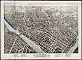
Lowell in 1876
-
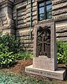
"A Mother's Hands" Armenian Genocide memorial outside of Lowell City Hall.
-
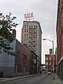
The Sun is the city's daily newspaper.


See also
 In Spanish: Lowell (Massachusetts) para niños
