Lower Tenthill, Queensland facts for kids
Quick facts for kids Lower TenthillQueensland |
|||||||||||||||
|---|---|---|---|---|---|---|---|---|---|---|---|---|---|---|---|

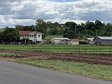
Houses and fields of lettuce, Lower Tenthill, 2022
|
|||||||||||||||
| Population | 252 (2016 census) | ||||||||||||||
| • Density | 9.66/km2 (25.0/sq mi) | ||||||||||||||
| Postcode(s) | 4343 | ||||||||||||||
| Area | 26.1 km2 (10.1 sq mi) | ||||||||||||||
| Time zone | AEST (UTC+10:00) | ||||||||||||||
| Location | |||||||||||||||
| LGA(s) | Lockyer Valley Region | ||||||||||||||
| State electorate(s) | Lockyer | ||||||||||||||
| Federal Division(s) | Wright | ||||||||||||||
|
|||||||||||||||
Lower Tenthill is a rural locality in the Lockyer Valley Region, Queensland, Australia. In the 2016 census, Lower Tenthill had a population of 252 people.
Education
Tent Hill Lower State School is a government primary (Prep-6) school for boys and girls at 90 Lower Tenthill Road (27°35′29″S 152°14′10″E / 27.5915°S 152.2361°E). In 2017, the school had an enrolment of 66 students with 6 teachers (5 full-time equivalent) and 5 non-teaching staff (2 full-time equivalent). In 2018, the school had an enrolment of 69 students with 5 teachers and 6 non-teaching staff (3 full-time equivalent).
There are no secondary schools in Lower Tenthill. The nearest government secondary school is Lockyer District State High School in neighbouring Gatton to the north-east.


