
Loyalsock Township, Lycoming County, Pennsylvania facts for kids
Quick facts for kids
Loyalsock Township, Pennsylvania
|
|
|---|---|
|
Township
|
|
  From top: Golden Strip; Railroad bridge over Loyalsock Creek
|
|
| Nickname(s):
Sock Township, Sock, The Sock
|
|

Location within Lycoming County
|
|

Loyalsock Township, Lycoming County, Pennsylvania
Location in Pennsylvania

Loyalsock Township, Lycoming County, Pennsylvania
Location in the United States
|
|
| Country | |
| State | |
| County | Lycoming |
| Settled | 1768 |
| Incorporated | 1786 |
| Area | |
| • Total | 21.50 sq mi (55.67 km2) |
| • Land | 21.15 sq mi (54.78 km2) |
| • Water | 0.34 sq mi (0.89 km2) |
| Elevation | 1,770 ft (524 m) |
| Population
(2020)
|
|
| • Total | 11,561 |
| • Density | 521.03/sq mi (203.50/km2) |
| Time zone | Eastern (EST) |
| • Summer (DST) | EDT |
| Area code(s) | 570 |
| FIPS code | 42-081-45224 |
Loyalsock Township is a township in Lycoming County, Pennsylvania, United States. The population was 11,026 at the 2010 census. It is part of the Williamsport Metropolitan Statistical Area. It is the second largest municipality in Lycoming County, in terms of population, behind the county seat Williamsport.
The township was settled in 1768 and incorporated in 1786. It is located on the north bank of the West Branch Susquehanna River. Native American artifacts can be commonly found in parks near the West Branch. Archaeologists have found over 1,500 pieces of Native American pottery, weaponry and other artifacts, some being displayed in collections in Philadelphia, Pittsburgh, and New York City. Most can be found at local museums in nearby Williamsport.
Contents
History
Loyalsock Township was formed from Muncy Township in February 1786 by the Northumberland County court. This was nine years prior to the formation of Lycoming County. The township was originally bounded by the West Branch Susquehanna River to the south, Loyalsock Creek was the eastern limit and Lycoming Creek was the western limit. As for the northern limit, this was undefined, it may have extended as far north as New York state. The city of Williamsport was formed in large measure from a great part of Loyalsock Township. Seventy-five percent of Williamsport's lands came from Loyalsock.
In the American Revolutionary War, settlements throughout the Susquehanna valley and what was to become Loyalsock Township were attacked by Loyalists and Native Americans allied with the British. After the Wyoming Valley battle and massacre in the summer of 1778 (near what is now Wilkes-Barre) and smaller local attacks, the "Big Runaway" occurred throughout the West Branch Susquehanna valley. Settlers fled feared and actual attacks by the British and their allies. Homes and fields were abandoned, with livestock driven along and a few possessions floated on rafts on the river east to Muncy, then further south to Sunbury. The abandoned property was burnt by the attackers. Some settlers soon returned, only to flee again in the summer of 1779 in the "Little Runaway". Sullivan's Expedition helped stabilize the area and encouraged resettlement, which continued after the war.
Isaac and William McKinney, father and son, built the McKinney Iron Works along Lycoming Creek in western Loyalsock Townshop between 1825 and 1830, when they built a forge, in an area known as Heshbon Park. Their operation was expanded in 1836 with the construction of an iron furnace and further still in 1841 when a rolling mill was added to the complex. Iron ore was transported down the West Branch Susquehanna River Valley and up Lycoming Creek to the iron works from Centre County. The McKinney's effort was ultimately unsuccessful. The efforts of two more iron masters also failed. The iron works was largely destroyed by a flood in 1865.
Daniel Hughes was a conductor in the Underground Railroad based in Loyalsock Township. He was the owner of a barge on the Pennsylvania Canal and transported lumber from Williamsport on the West Branch Susquehanna River to Havre de Grace, Maryland. Hughes hid runaway slaves in the hold of his barge on his return trip up the Susquehanna River to Lycoming County where he provided shelter on his property near the Loyalsock Township border with Williamsport before moving further north and to eventual freedom in Canada. Hughes' home was located in a hollow or small valley in the mountains just north of Williamsport. This hollow is now known as Freedom Road. In response to the actions of concerned African American citizens of Williamsport, the pejorative name was formally changed by the Williamsport City Council in 1936.
Today, the flood plain between Williamsport and Montoursville is densely populated with family residences and a shopping district known as the "Golden Strip" along East Third Street. The northern and western parts of the township are less heavily populated but still there are many family homes and small businesses. The population of Loyalsock Township has grown to 10,876 (2000 census) this is up from 2,498 (1890 census).
Geography
Loyalsock Township is bordered by Montoursville, Fairfield and Upper Fairfield Township to the east. These eastern borders are formed by Loyalsock Creek. The township is bordered by Williamsport and the West Branch Susquehanna River to the south (with Armstrong Township south of the river). Williamsport also forms the eastern border along with Lycoming Creek which is the dividing line between Loyalsock and Old Lycoming Township. The townships of Hepburn and Eldred form the northern border. As the crow flies, Lycoming County is about 130 miles (209 km) northwest of Philadelphia and 165 miles (266 km) east-northeast of Pittsburgh.
According to the United States Census Bureau, the township has a total area of 21.2 square miles (55.0 km2).21.0 square miles (54.4 km2) of it is land and 0.2 square miles (0.6 km2) of it (1.13%) is water.
Demographics
| Historical population | |||
|---|---|---|---|
| Census | Pop. | %± | |
| 1890 | 769 | — | |
| 1900 | 2,567 | 233.8% | |
| 1910 | 4,765 | 85.6% | |
| 1920 | 5,498 | 15.4% | |
| 1930 | 8,949 | 62.8% | |
| 1940 | 9,698 | 8.4% | |
| 1950 | 10,071 | 3.8% | |
| 1960 | 10,103 | 0.3% | |
| 1970 | 9,765 | −3.3% | |
| 1980 | 9,987 | 2.3% | |
| 1990 | 10,019 | 0.3% | |
| 2000 | 10,876 | 8.6% | |
| 2010 | 11,026 | 1.4% | |
| 2016 (est.) | 11,148 | 1.1% | |
| U.S. Decennial Census | |||
As of the census of 2000, there were 10,876 people, 4,501 households, and 2,966 families residing in the township. The population density was 517.6 people per square mile (199.9/km2). There were 4,687 housing units at an average density of 223.1/sq mi (86.1/km2). The racial makeup of the township was 94.81% White, 2.64% African American, 0.13% Native American, 1.05% Asian, 0.01% Pacific Islander, 0.33% from other races, and 1.03% from two or more races. Hispanic or Latino of any race were 0.86% of the population.
There were 4,501 households, out of which 26.1% had children under the age of 18 living with them, 53.5% were married couples living together, 9.5% had a female householder with no husband present, and 34.1% were non-families. 31.0% of all households were made up of individuals, and 18.9% had someone living alone who was 65 years of age or older. The average household size was 2.25 and the average family size was 2.80.
In the township the population was spread out, with 20.7% under the age of 18, 5.0% from 18 to 24, 20.7% from 25 to 44, 24.3% from 45 to 64, and 29.4% who were 65 years of age or older. The median age was 47 years. For every 100 females there were 81.6 males. For every 100 females age 18 and over, there were 76.0 males.
The median income for a household in the township was $36,806, and the median income for a family was $47,952. Males had a median income of $39,623 versus $24,684 for females. The per capita income for the township was $23,480. About 6.8% of families and 8.7% of the population were below the poverty line, including 15.7% of those under age 18 and 4.3% of those age 65 or over.
Departments
Police
Loyalsock does not have its own police department the township is policed by the Pennsylvania State Police.
Fire and rescue
The local fire department is Loyalsock Volunteer Fire Company it has an EMS department that is on site 24/7, and fire and rescue fire departments.
Economy
Top employers
| # | Employer | # of Employees |
|---|---|---|
| 1 | Loyalsock School District | 209 |
| 2 | Loyalsock Township | 189 |
| 3 | Liberty Mutual | 111 |
| 4 | Valley Farms Dairy | 83 |
| 5 | UPMC Susquehanna Divine Providence | 49 |
Education
Loyalsock Township School District consists of a high school, middle school and elementary school. All schools in the district rank in the top 150 in the state in test scores and teacher preparedness.
The schools in the district are:
- Donald E. Schick Elementary (formerly known as Four Mile Elementary)
- Loyalsock Township Middle School
- Loyalsock Township High School
A lancer is the mascot for the school district. The school colors are maroon and white.
Transportation
Major roadways
 - Interstate 180
- East Third Street
- Washington Boulevard
- Four Mile Drive
- Northway Road
- Lycoming Creek Road
- Warrensville Road
- Poco Farm Road
- Bloomingrove Road
The southern part of the township is crossed by Interstate 180, with two exits (Exits 25 and 23) into Loyalsock. I-180 leads west 4 miles (6 km) to its western terminus in Williamsport, and southeast 25 miles (40 km) to Interstate 80 near Milton. U.S. Route 220 runs concurrently with I-180 through the township.
The township has multiple major roadways, most notably East Third Street which begins in Williamsport to the west and ends at the township's eastern border with Montoursville, where the road name changes to Broad Street. Northway Road begins at Exit 25 off I-180 and continues north until it reaches the township's north border. Four Mile Drive begins at the township's western boarder with Williamsport and stretches to Warrensville Road near the eastern border and Loyalsock Creek. Four Mile Drive has a mixture of commercial and residential properties, including Donald E. Schick Elementary School and Divine Providence Hospital.
Air
Located in neighboring Montoursville is Williamsport Regional Airport (KIPT/IPT). As of September 30, 2021, there is no commercial airline service.
Rail
The Lycoming Valley Railroad runs along the West Branch Susquehanna River on the southern border of the township.
Notable people
The following are notable people who were born, lived or currently reside within the township:
- Pat Daneker, former Major League Baseball pitcher
- Bob Farley, former MLB outfielder
- Dylan Rockoff, singer
- Jeff Wheeland, politician
- Tom Woodruff Jr., actor
- Gene Yaw, politician
Images for kids
-
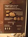
Native American stone tools excavated from Canfield Island in the West Branch Susquehanna River, seen from exhibit at the Lycoming County Historical Museum in Williamsport
-
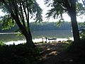
Canfield Island looking out onto the West Branch Susquehanna River in Loyalsock Township in August 2009


See also
 In Spanish: Municipio de Loyalsock (condado de Lycoming, Pensilvania) para niños
