
Loyalton, California facts for kids
Quick facts for kids
City of Loyalton
|
|
|---|---|
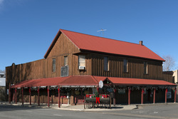
Sierra Valley Home Center in Loyalton
|
|

Location in Sierra County and the state of California
|
|

Loyalton, California
Location in the United States
|
|
| Country | |
| State | |
| County | Sierra |
| Incorporated | August 21, 1901 |
| Government | |
| • Type | Council–manager |
| Area | |
| • Total | 0.35 sq mi (0.92 km2) |
| • Land | 0.35 sq mi (0.92 km2) |
| • Water | 0.00 sq mi (0.00 km2) 0% |
| Elevation | 4,951 ft (1,509 m) |
| Population
(2020)
|
|
| • Total | 740 |
| • Estimate
(2019)
|
702 |
| • Density | 2,114.3/sq mi (804.3/km2) |
| Time zone | UTC-8 (Pacific (PST)) |
| • Summer (DST) | UTC-7 (PDT) |
| ZIP code |
96118
|
| Area code(s) | 530 |
| FIPS code | 06-44364 |
| GNIS feature ID | 0277550 |
Loyalton is a city in Sierra County, California, United States. At the 2020 census, the population was 740, reflecting a decline of 29 from the 769 counted in 2010. The ZIP code for the community is 96118. The town is near the north extent of State Route 49, which ends at State Route 70 in Vinton. According to Rand-McNally, it is a fifty-mile drive on State Route 49 to the county seat, Downieville. Many of the population are ranchers, loggers, former loggers, or suburbanites who have relocated from the San Francisco Bay Area, Sacramento, and growing Reno–Tahoe area.
Geography
Loyalton is located at 39°40′36″N 120°14′35″W / 39.67667°N 120.24306°W (39.676558, -120.243157). Elevation above mean sea level for the area was listed as roughly 4,930 feet (1,500 m).
According to the United States Census Bureau, the city has a total area of 0.4 square miles (1.0 km2), all land.
Climate
This region experiences warm (but not hot) and dry summers, with no average monthly temperatures above 71.6 °F. According to the Köppen Climate Classification system, Loyalton has a warm-summer Mediterranean climate, abbreviated "Csb" on climate maps.
Demographics
| Historical population | |||
|---|---|---|---|
| Census | Pop. | %± | |
| 1880 | 84 | — | |
| 1910 | 983 | — | |
| 1920 | 442 | −55.0% | |
| 1930 | 837 | 89.4% | |
| 1940 | 925 | 10.5% | |
| 1950 | 911 | −1.5% | |
| 1960 | 936 | 2.7% | |
| 1970 | 945 | 1.0% | |
| 1980 | 1,030 | 9.0% | |
| 1990 | 931 | −9.6% | |
| 2000 | 862 | −7.4% | |
| 2010 | 769 | −10.8% | |
| 2019 (est.) | 702 | −8.7% | |
| U.S. Decennial Census | |||
2020
At the 2020 census Loyalton had a population of 740. The population density was 2114.3 people per square mile (804.3/km2). The racial makeup of Loyalton was 601 (81.2%) White, 4 (0.5%) African American, 9 (1.2%) Native American, 0 (0.0%) Asian, 1 (0.1%) Pacific Islander, 45 (6.1%) from other races, and 80 (10.8%) from two or more races. Hispanic or Latino of any race were 127 people (17.6%).
2010
At the 2010 census Loyalton had a population of 769. The population density was 21 people per square mile (835.2/km2). The racial makeup of Loyalton was 701 (91.2%) White, 2 (0.3%) African American, 21 (2.7%) Native American, 0 (0.0%) Asian, 0 (0.0%) Pacific Islander, 20 (2.6%) from other races, and 25 (3.3%) from two or more races. Hispanic or Latino of any race were 108 people (14.0%).
The census reported that 738 people (96.0% of the population) lived in households, no one lived in non-institutionalized group quarters and 31 (4.0%) were institutionalized.
There were 308 households, 86 (27.9%) had children under the age of 18 living in them, 163 (52.9%) were opposite-sex married couples living together, 28 (9.1%) had a female householder with no husband present, 19 (6.2%) had a male householder with no wife present. There were 25 (8.1%) unmarried opposite-sex partnerships, and 0 (0%) same-sex married couples or partnerships. 81 households (26.3%) were one person and 35 (11.4%) had someone living alone who was 65 or older. The average household size was 2.40. There were 210 families (68.2% of households); the average family size was 2.84.
The age distribution was 156 people (20.3%) under the age of 18, 55 people (7.2%) aged 18 to 24, 164 people (21.3%) aged 25 to 44, 243 people (31.6%) aged 45 to 64, and 151 people (19.6%) who were 65 or older. The median age was 46.2 years. For every 100 females, there were 101.3 males. For every 100 females age 18 and over, there were 98.4 males.
There were 371 housing units at an average density of 1,043.6 per square mile, of the occupied units 225 (73.1%) were owner-occupied and 83 (26.9%) were rented. The homeowner vacancy rate was 3.4%; the rental vacancy rate was 8.8%. 526 people (68.4% of the population) lived in owner-occupied housing units and 212 people (27.6%) lived in rental housing units.
2000
At the 2000 census there were 862 people in 323 households, including 235 families, in the city. The population density was 2,516.4 people per square mile (978.9/km2). There were 347 housing units at an average density of 1,013.0 per square mile (394.1/km2). The racial makeup of the city was 94.90% White, 0.23% African American, 2.67% Native American, 0.12% Asian, 0.58% from other races, and 1.51% from two or more races. Hispanic or Latino of any race were 7.19%.
Of the 323 households 38.4% had children under the age of 18 living with them, 53.6% were married couples living together, 11.1% had a female householder with no husband present, and 27.2% were non-families. 23.8% of households were one person and 10.2% were one person aged 65 or older. The average household size was 2.58 and the average family size was 3.00.
The age distribution was 29.1% under the age of 18, 6.0% from 18 to 24, 24.8% from 25 to 44, 24.4% from 45 to 64, and 15.7% 65 or older. The median age was 39 years. For every 100 females, there were 94.6 males. For every 100 females age 18 and over, there were 91.5 males.
The median income for a household in the city was $34,063, and the median family income was $39,750. Males had a median income of $38,864 versus $23,571 for females. The per capita income for the city was $15,732. About 20.3% of families and 18.1% of the population were below the poverty line, including 22.0% of those under age 18 and 6.7% of those age 65 or over.
See also
 In Spanish: Loyalton (California) para niños
