Lubbock County, Texas facts for kids
Quick facts for kids
Lubbock County
|
|
|---|---|

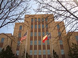
The current Lubbock County Courthouse
|
|

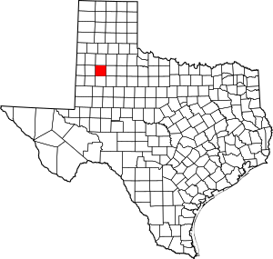
Location within the U.S. state of Texas
|
|
 Texas's location within the U.S. |
|
| Country | |
| State | |
| Founded | 1891 |
| Named for | Thomas Saltus Lubbock |
| Seat | Lubbock |
| Largest city | Lubbock |
| Area | |
| • Total | 901 sq mi (2,330 km2) |
| • Land | 896 sq mi (2,320 km2) |
| • Water | 5.1 sq mi (13 km2) 0.6% |
| Population
(2020)
|
|
| • Total | 310,639 |
| • Density | 344.77/sq mi (133.12/km2) |
| Time zone | UTC−6 (Central) |
| • Summer (DST) | UTC−5 (CDT) |
| Congressional district | 19th |
Lubbock County is a county located in the U.S. state of Texas. The 2020 census placed the population at 310,639. Its county seat and largest city is Lubbock. The county was created in 1876 and organized in 1891. It is named for Thomas Saltus Lubbock, a Confederate colonel and Texas Ranger (some sources give his first name as Thompson).
Lubbock County, along with Crosby County, and Lynn County, is part of the Lubbock Metropolitan Statistical Area (MSA). The Lubbock MSA and Levelland Micropolitan Statistical Area, encompassing only Hockley County, form the larger Lubbock–Levelland Combined Statistical Area.
Contents
Geography
According to the U.S. Census Bureau, the county has a total area of 901 square miles (2,330 km2), of which 896 square miles (2,320 km2) is land and 5.1 square miles (13 km2) (0.6%) is water.
Major highways
 Interstate 27
 U.S. Highway 62/U.S. Highway 82
 U.S. Highway 84
 U.S. Highway 87
 State Highway 114
 Loop 289
Adjacent counties
- Hale County (north)
- Crosby County (east)
- Lynn County (south)
- Hockley County (west)
- Lamb County (northwest)
- Terry County (southwest)
- Garza County (southeast)
Demographics
| Historical population | |||
|---|---|---|---|
| Census | Pop. | %± | |
| 1880 | 25 | — | |
| 1890 | 33 | 32.0% | |
| 1900 | 293 | 787.9% | |
| 1910 | 3,624 | 1,136.9% | |
| 1920 | 11,096 | 206.2% | |
| 1930 | 39,104 | 252.4% | |
| 1940 | 51,782 | 32.4% | |
| 1950 | 101,048 | 95.1% | |
| 1960 | 156,271 | 54.7% | |
| 1970 | 179,295 | 14.7% | |
| 1980 | 211,651 | 18.0% | |
| 1990 | 222,636 | 5.2% | |
| 2000 | 242,628 | 9.0% | |
| 2010 | 278,831 | 14.9% | |
| 2020 | 310,639 | 11.4% | |
| U.S. Decennial Census 1850–2010 2010 2020 |
|||
2020 census
| Race / Ethnicity | Pop 2010 | Pop 2020 | % 2010 | % 2020 |
|---|---|---|---|---|
| White alone (NH) | 159,815 | 154,994 | 57.32% | 49.90% |
| Black or African American alone (NH) | 19,957 | 25,663 | 7.16% | 8.26% |
| Native American or Alaska Native alone (NH) | 1,026 | 1,436 | 0.37% | 0.46% |
| Asian alone (NH) | 5,650 | 9,490 | 2.03% | 3.05% |
| Pacific Islander alone (NH) | 161 | 180 | 0.06% | 0.06% |
| Some Other Race alone (NH) | 284 | 968 | 0.10% | 0.31% |
| Mixed Race/Multi-Racial (NH) | 3,014 | 8,738 | 1.08% | 2.81% |
| Hispanic or Latino (any race) | 88,924 | 109,170 | 31.89% | 35.14% |
| Total | 278,831 | 310,639 | 100.00% | 100.00% |
Note: the US Census treats Hispanic/Latino as an ethnic category. This table excludes Latinos from the racial categories and assigns them to a separate category. Hispanics/Latinos can be of any race.
Communities
Cities
- Abernathy (mostly in Hale County)
- Idalou
- Lubbock (county seat)
- Shallowater
- Slaton
- Wolfforth
Towns
Village
Unincorporated communities
Ghost Town
- Estacado (partly in Crosby County)
See also
 In Spanish: Condado de Lubbock para niños


