
Lucas County, Ohio facts for kids
Quick facts for kids
Lucas County
|
|||
|---|---|---|---|

The Lucas County Courthouse in Toledo
|
|||
|
|||

Location within the U.S. state of Ohio
|
|||
 Ohio's location within the U.S. |
|||
| Country | |||
| State | |||
| Founded | June 20, 1835 | ||
| Named for | Robert Lucas | ||
| Seat | Toledo | ||
| Largest city | Toledo | ||
| Area | |||
| • Total | 596 sq mi (1,540 km2) | ||
| • Land | 341 sq mi (880 km2) | ||
| • Water | 255 sq mi (660 km2) 43%% | ||
| Population
(2020)
|
|||
| • Total | 431,279 | ||
| • Density | 723.6/sq mi (279.39/km2) | ||
| Time zone | UTC−5 (Eastern) | ||
| • Summer (DST) | UTC−4 (EDT) | ||
| Congressional districts | 5th, 9th | ||


Lucas County is a county located in the northwestern part of the U.S. state of Ohio. It is bordered to the east by Lake Erie, and to the southeast by the Maumee River, which runs to the lake. As of the 2020 census, the population was 431,279. Its county seat is Toledo, located at the mouth of the Maumee River on the lake. The county was named for Robert Lucas, 12th governor of Ohio, in 1835 during his second term. Its establishment provoked the Toledo War conflict with the Michigan Territory, which claimed some of its area. Lucas County is named after Robert Lucas, 12th Governor of the State of Ohio and the winning governor of the Toledo War, and is the central county of the Toledo Metropolitan Statistical Area.
Contents
History
On August 20, 1794, near the site of the present-day town of Maumee, American forces led by General Anthony Wayne won a decisive victory over allied Indian forces at the Battle of Fallen Timbers after years of conflict in what was known as the Northwest Indian War. The defeat of the Native forces resulted in the opening of the entire Northwest Territory for white settlement. Northwest Ohio was occupied chiefly by villages and bands of the Odawa people, who had trading relations with the French at Fort Detroit since 1701. Other Odawa were located in southeast Michigan and further north on the peninsula. They ceded much of that territory in the Treaty of Greenville but retained control of lands along the Maumee River until after the War of 1812. The last Odawa band, that of Ottokee, grandson of Chief Pontiac, left the Maumee River area for Kansas in 1839.

Lucas County was established in 1835. At that time, both Ohio and Michigan Territory claimed sovereignty over a 468-square-mile (1,210 km2) region along their border (see Toledo War). When Michigan petitioned Congress for statehood in 1835, it sought to include the disputed territory within its bounds. In response, the Ohio General Assembly formally organized part of the area as Lucas County, naming it after the incumbent governor of Ohio, Robert Lucas.
Geography

According to the U.S. Census Bureau, the county has a total area of 596 square miles (1,540 km2), of which 341 square miles (880 km2) is land and 255 square miles (660 km2) (43%) is water. It is the fourth-smallest county in Ohio by land area. Much of the county lies within what was at the time of its establishment, a vast network of forests, wetlands, and grasslands known as the Great Black Swamp.
Rivers
Adjacent counties
- Monroe County, Michigan (north)
- Essex County, Ontario (northeast)
- Ottawa County (southeast)
- Wood County (south)
- Henry County (southwest)
- Fulton County (west)
- Lenawee County, Michigan (northwest)
National protected areas
- Cedar Point National Wildlife Refuge
- Ottawa National Wildlife Refuge (part)
- West Sister Island National Wildlife Refuge
Major highways
 I-73 (future)
 Interstate 75
 Interstate 80
 Interstate 90
 Interstate 280
 Interstate 475
 U.S. Highway 20
 U.S. Highway 23
 U.S. Highway 24
Demographics
| Historical population | |||
|---|---|---|---|
| Census | Pop. | %± | |
| 1840 | 9,382 | — | |
| 1850 | 12,363 | 31.8% | |
| 1860 | 25,831 | 108.9% | |
| 1870 | 46,722 | 80.9% | |
| 1880 | 67,377 | 44.2% | |
| 1890 | 102,296 | 51.8% | |
| 1900 | 153,559 | 50.1% | |
| 1910 | 192,728 | 25.5% | |
| 1920 | 275,721 | 43.1% | |
| 1930 | 347,709 | 26.1% | |
| 1940 | 344,333 | −1.0% | |
| 1950 | 395,551 | 14.9% | |
| 1960 | 456,931 | 15.5% | |
| 1970 | 484,370 | 6.0% | |
| 1980 | 471,741 | −2.6% | |
| 1990 | 462,361 | −2.0% | |
| 2000 | 455,054 | −1.6% | |
| 2010 | 441,815 | −2.9% | |
| 2020 | 431,279 | −2.4% | |
| U.S. Decennial Census 1790-1960 1900-1990 1990-2000 2020 |
|||
2010 census
As of the 2010 census, there were 441,815 people, 180,267 households, and 111,016 families living in the county. The population density was 1,296.2 inhabitants per square mile (500.5/km2). There were 202,630 housing units at an average density of 594.5 per square mile (229.5/km2). The racial makeup of the county was 74.0% white, 19.0% black or African American, 1.5% Asian, 0.3% American Indian, 2.0% from other races, and 3.1% from two or more races. Those of Hispanic or Latino origin made up 6.1% of the population. In terms of ancestry, 29.8% were German, 13.2% were Irish, 9.7% were Polish, 8.0% were English, and 3.8% were American.
Of the 180,267 households, 31.1% had children under the age of 18 living with them, 40.0% were married couples living together, 16.5% had a female householder with no husband present, 38.4% were non-families, and 31.4% of all households were made up of individuals. The average household size was 2.39 and the average family size was 3.01. The median age was 37.0 years.
The median income for a household in the county was $42,072 and the median income for a family was $54,855. Males had a median income of $46,806 versus $33,394 for females. The per capita income for the county was $23,981. About 14.0% of families and 18.0% of the population were below the poverty line, including 25.4% of those under age 18 and 8.7% of those age 65 or over.
Communities

Cities
- Maumee
- Oregon
- Sylvania
- Toledo (county seat)
- Waterville
Villages
- Berkey
- Harbor View
- Holland
- Ottawa Hills
- Swanton
- Whitehouse
Townships
- Harding
- Jerusalem
- Monclova
- Providence
- Richfield
- Spencer
- Springfield
- Swanton
- Sylvania
- Washington
- Waterville
Census-designated places
Unincorporated Communities
Ghost towns
Economy
Top Employers
According to the county's 2019 Comprehensive Annual Financial Report, the top ten employers in the county are:
| # | Employer | # of employees |
|---|---|---|
| 1 | Promedica Health Services | 11,517 |
| 2 | University of Toledo | 8,502 |
| 3 | Fiat Chrysler - Toledo North Plant; Toledo South Plant | 6,759 |
| 4 | Mercy Health Partners | 5,880 |
| 5 | Toledo Public Schools | 3,193 |
| 6 | Lucas County | 2,821 |
| 7 | City of Toledo | 2,748 |
| 8 | Kroger | 2,300 |
| 9 | Walmart | 1,954 |
| 10 | General Motors - Powertrain | 1,778 |
Images for kids
-
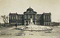
Lucas County Courthouse, 1910s
-
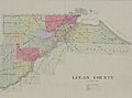
Historical map of Lucas County, 1899
.jpg)
.jpg)
See also
 In Spanish: Condado de Lucas (Ohio) para niños
