
Lucerne Valley, California facts for kids
Quick facts for kids
Lucerne Valley
|
||
|---|---|---|
 |
||
|
||

Lucerne Valley
Location in California
|
||
| Country | USA | |
| State | ||
| County | San Bernardino | |
| Area | ||
| • Total | 105.590 sq mi (273.477 km2) | |
| • Land | 105.590 sq mi (273.477 km2) | |
| • Water | 0 sq mi (0 km2) 0% | |
| Elevation | 2,953 ft (900 m) | |
| Population
(2010)
|
||
| • Total | 5,811 | |
| • Density | 55.034/sq mi (21.2486/km2) | |
| Time zone | UTC-8 (Pacific (PST)) | |
| • Summer (DST) | UTC-7 (PDT) | |
| ZIP code |
92356
|
|
| Area codes | 442/760 | |
| GNIS Feature IDs | 272271; 2627937 | |
Lucerne Valley is a census-designated place (CDP) and valley landform in the southern Mojave Desert, in western San Bernardino County, California.
Contents
Geography
.jpg)
The geographic valley is defined by the surrounding Granite Mountains, Ord Mountains, and San Bernardino Mountains.
Lucerne Valley lies east of the Victor Valley, whose population nexus includes Victorville, Apple Valley, Adelanto and Hesperia. It is located 19 miles (31 km) east of Apple Valley, and 20 miles (32 km) north of Big Bear Lake. Distant surrounding communities include Yucca Valley which lies 45 miles (72 km) east via State Route 247/Old Woman Springs Road, and Barstow, which is 26 miles (42 km) north via State Route 247/Barstow Road.
The transportation nexus of Lucerne Valley is located where State Route 247 and State Route 18 are connected by Old Woman Springs and Barstow Roads, the two highways do not have a direct junction.
In San Bernardino County, Lucerne Valley's area is also identified as County Service Area 29. While Lucerne Valley's "town limit" signs are within 2 miles of each other, the County Service Area Limits are much larger: in the west to Joshua Road (unpaved road east of Milpas Rd. on Hwy. 18), to the north at the 4,000 feet (1,200 m) height of Ord Mountain on Highway 247, to the south at the entrance to Cushenbury Canyon on Highway 18, and at Old Woman Springs Ranch as the eastern boundary. On June 11, 2013, Lucerne Valley and Johnson Valley were merged under the same Municipal Advisory Council, which serves as an advisory reporting agency to the County of San Bernardino District Supervisor concerning the region. On August 14, 2013, Johnson Valley was sworn in to the same Municipal Advisory Council as Lucerne Valley. CSA 29's borders, however, remain unchanged from the move.
According to the United States Census Bureau, the CDP covers an area of 105.6 square miles (273.5 km²), all of it land.
Climate
According to the Köppen Climate Classification system, Lucerne Valley has a semi-arid climate, abbreviated "BSk" on climate maps.
Demographics
The 2010 United States Census reported that Lucerne Valley had a population of 5,811. The population density was 55 persons per square mile (21.2/km2). The racial makeup of Lucerne Valley was 4,507 (77.6%) White (66.8% Non-Hispanic White), 170 (2.9%) African American, 106 (1.8%) Native American, 90 (1.5%) Asian, 0 (0.0%) Pacific Islander, 676 (11.6%) from other races, and 262 (4.5%) from two or more races. Hispanic or Latino of any race were 1,447 persons (24.9%).
The census reported that 5,780 people (99.5% of the population) lived in households, 31 (0.5%) lived in non-institutionalized group quarters, and zero (0%) were institutionalized.
There were 2,176 households, out of which 685 (31.5%) had children under the age of 18 living in them, 954 (43.8%) were opposite-sex married couples living together, 280 (12.9%) had a female householder with no husband present, 157 (7.2%) had a male householder with no wife present. There were 146 (6.7%) unmarried opposite-sex partnerships, and 14 (0.6%) same-sex married couples or partnerships. Sole individuals occupied 632 households (29.0%) and 255 (11.7%) had someone living alone who was 65 years of age or older. The average household size was 2.66. There were 1,391 families (63.9% of all households); the average family size was 3.28.
The population was spread out, with 1,424 people (24.5%) under the age of 18, 452 people (7.8%) aged 18 to 24, 1,214 people (20.9%) aged 25 to 44, 1,780 people (30.6%) aged 45 to 64, and 941 people (16.2%) who were 65 years of age or older. The median age was 42.7 years. For every 100 females, there were 106.1 males. For every 100 females age 18 and over, there were 105.4 males.
There were 2,949 housing units at an average density of 27.9 per square mile (10.8/km2), of which 1,454 (66.8%) were owner-occupied, and 722 (33.2%) were occupied by renters. The homeowner vacancy rate was 4.3%; the rental vacancy rate was 9.0%. Three thousand eight hundred people (65.4% of the population) lived in owner-occupied housing units and 1,980 people (34.1%) lived in rental housing units.
According to the 2010 United States Census, Lucerne Valley had a median household income of $30,142, with 18.4% of the population living below the federal poverty line.
Development
Zoning
The majority of Lucerne Valley's zoning consists of Rural Residential, Resource Conservation and Agricultural zones.
Industrial zoning is predominantly in the southern border of the community on the north-facing slopes of the San Bernardino Mountains.
The commercial zoning corridor is primarily on State Route 18, with outlying businesses within a mile of the eastern half of the Old Woman Springs/Barstow Road junction. Commercial development is focused on mixed-use development, with storefronts facing the highway and a private residence on the same property behind the business on the same lot. Traditional retail construction has been restrained in the latter half of the 20th Century to keep the rural character of the town intact, but in September 2015 a Dollar General store opened as the first franchise grocery retail to enter town limits.
All residential zones are classified as Rural, Single or Medium density. Most housing developments are tract-based and were completed prior to the 1990s. No further tract-based construction projects have occurred in 20 years, with most new construction done individually on privately owned lots. An attempt to construct a golf course and install utilities for residential/commercial zones called "Rancho Lucerne" began grading north of the High School site before embezzlement charges filed against the financier caused the project to shut down in 2001, leaving the site abandoned and desert habitat destroyed.
Utilities
Utilities development projects have met with mixed reactions from residents and state/county officials, including solar power plants and wind turbine plants, and water well drilling and export proposals. They all would transport local resources for statewide use: such as power added to state grid through CalISO; or as water rights for power projects cooling purposes or for direct use by the Los Angeles Department of Water and Power (LADWP) to the Los Angeles metropolitan area. In 2012, LADWP cancelled an attempt to install a 2 mile wide water and power corridor in the southern half of the town.
Features
- Lucerne Dry Lake and Rabbit Springs Dry Lake — two dry lakes within the Lucerne Valley. A variety of small meteorites have been found and documented from these two dry lakes. The Critically endangered wildflower Parish's popcornflower (Plagiobothrys parishii) is native to the springs of Rabbit Springs Dry Lake. The dry lakes have been used for filming projects. Selena Gomez shot her music video for "A Year Without Rain" on Rabbit Springs Dry Lake.

- Blackhawk Landslide — a prehistoric landslide that is one of the largest known in North America is in the southeast corner of the Lucerne Valley.
- Chimney Rock — a registered California Historical Landmark, located in the mountains north of the Rabbit Springs Dry Lake and of Highway 18 near the Rabbit Springs Road junction. It is the site of the last battle between immigrant settlers and a Native American tribe in the Mojave Desert. Conflicts between Indians and white settlers over the rich lands of the San Bernardino Mountains culminated in the battle at Chimney Rock on February 16, 1867. Although the Indians defended themselves fiercely, they were forced to retreat into the desert. In the years following, the Indians' traditional mountain food gathering areas were lost to white encroachment. A historical marker is beside Highway 18, next to the welcome sign on the town's western border.
Parks
Parks in the Lucerne Valley include:
- Pioneer Park, next to the County Fire Station, is the main park for San Bernardino County's CSA 29 and used for most public community events. The Lucerne Valley Museum is located in the park, and has self-guided tours.
- Midway Park, at Midway and Rabbit Springs Roads, is the location of the Midway Schoolhouse and Equestrian Arena.
- Visalia Park broke ground in October 2015, and has a planned opening in latter 2016.
- The Johnson Valley OHV Area is mostly within Johnson Valley, and bordered on the west by Lucerne Valley. 2012 expansion plans for the Marine Corps Air Ground Combat Center Twentynine Palms may close the majority of the OHV area for 25 years or longer, and would end the "The Hammers" seasonal off-road vehicle race that brings annual business to Lucerne Valley.
- Mojave Trails National Monument is located to the east and north of the Lucerne Valley.
Education
Lucerne Valley Unified School District operates three school campuses run by Lucerne Valley Unified School District. Lucerne Valley Elementary School, built in 1952, serves grades K–5. Lucerne Valley Middle School was built in 1986 and formerly served grades 6–8. Lucerne Valley High School was built in 1992 and serve grades 6–12 after merging the portables from the prior middle school site onto the campus in 1998. The high school's first graduating class was in 1995. The school district office, community day school, and Mountain View High School have moved into the former Lucerne Valley Middle School site in the 2000's.
The Lucerne Valley Unified School District has had difficulty in recent years with financial issues, and lower than average test scores compared to San Bernardino County schools,. The school district reported a student population of fewer than 800 pupils as of September 2015.
Images for kids
-
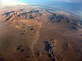
Lucerne Valley in the Mojave Desert
-
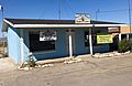
Lucerne Valley Chamber of Commerce.
-
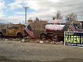
Cafe 247, as seen from CA-247, in Lucerne Valley, California.
.jpg)


See also
 In Spanish: Lucerne Valley para niños
