
Luquillo, Puerto Rico facts for kids
Quick facts for kids
Luquillo
Municipio de Luquillo
|
|||
|---|---|---|---|
|
Town and Municipality
|
|||

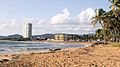
High rise buildings in Luquillo.
|
|||
|
|||
| Nicknames:
"Capital del Sol", "La Riviera de Puerto Rico", "Los Come Cocos"
|
|||
| Anthem: "Junto a las costas del mar Atlántico" | |||

Map of Puerto Rico highlighting Luquillo Municipality
|
|||
| Commonwealth | |||
| Founded | 1797 | ||
| Barrios | |||
| Area | |||
| • Total | 34.26 sq mi (88.73 km2) | ||
| • Land | 26 sq mi (68 km2) | ||
| • Water | 8.00 sq mi (20.73 km2) | ||
| Population
(2020)
|
|||
| • Total | 17,781 | ||
| • Density | 519.02/sq mi (200.394/km2) | ||
| Demonym(s) | Luquillenses or Luquillanos | ||
| Time zone | UTC−4 (AST) | ||
| ZIP Code |
00773
|
||
| Area code(s) | 787/939 | ||
| Major routes | |||


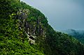
Luquillo is a town and municipality of Puerto Rico located in the northeast coast, northwest of Fajardo; and east of Rio Grande. Luquillo is spread over 5 barrios and Luquillo Pueblo (the downtown area and the administrative center of the city). It lends its name to the Sierra de Luquillo, where El Yunque National Forest is located. It is part of the Fajardo Metropolitan Statistical Area.
The city of Luquillo is 26 square miles and it sits on 12 miles of Atlantic coastline. It is nestled between the blue waters of the Atlantic and the El Yunque National Forest, a rainforest, giving it a diverse and unique ecology. Luquillo marks the beginning of the Northeast Ecological Corridor Nature Reserve which runs down the coast from downtown Luquillo all the way down to the Seven Seas Beach in Fajardo. During certain times of the year, it is not unusual to encounter rare or endangered species of fauna (like the leatherback turtle) while visiting in Luquillo.
Contents
History
Luquillo was founded in 1797 and is known as "La Capital del Sol" (sun capital), "La Riviera de Puerto Rico" (Puerto Rico's riviera), and "Los Come Cocos" (The coconut eaters). The town was named after the Indian cacique Loquillo, who died a few years after the last Indian rebellion in 1513.
Cityscape
Barrios
- Juan Martín
- Luquillo Pueblo
- Mameyes I
- Mata de Plátano
- Pitahaya
- Sabana
- Fortuna Playa
- Fortuna Carretera
- Rio Chiquito
- Casa Blanca
- Villa Angelina
- Estancias Del Atlantico
Tourism

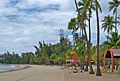
If you stay on the coastal highway going east from San Juan, you'll soon reach Luquillo Beach. This huge plantation of majestic coconut palms shades more than a mile of fine and shimmering sand. It is one of the most popular and nicest public beaches in the San Juan area. It offers cafeterias, public bathrooms with showers, access for disabled people, and an ample parking lot. Monserrate Beach is one of the public beaches most frequented by the locals. In 2006 El Balneario de Luquillo (The Luquillo Beach) was pronounced the most popular one in Puerto Rico. La Pared Beach is also very popular for its surf worthy waves.
La Selva, is a small cove on the east coast. It is arguably one of the best surf spots on the east coast. The only way to get to it is about a 2-mile walk through a cow farm, but it's worth the trip if you can talk someone into telling you how to get there.
Landmarks and places of interest
- Chief Loquillo Monument
- La Fortuna Hacienda
- La Bandera Beach
- La Monserrate Beach
- La Pared Beach
- Las Pailas Beach
- Luquillo Beach
- Mameyes Beach
- Ocean View Boulevard
- Fortuna Beach
- El Parque de Recreacion
- El Balneario
- The Kiosks
- The Brass Cactus Restaurant
- Lolitas Restaurant
- La Selva Reef Break
Culture
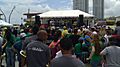
Festivals and events
- Patron Saint Celebrations - March
- Leatherback Turtle Festival - April
- Coconut Festival - September
- Typical Dish Festival - December
- The Three Kings Day Celebration at The Luquillo Plaza - January
Demographics
| Historical population | |||
|---|---|---|---|
| Census | Pop. | %± | |
| 1920 | 6,251 | — | |
| 1930 | 7,799 | 24.8% | |
| 1940 | 8,851 | 13.5% | |
| 1950 | 9,967 | 12.6% | |
| 1960 | 8,582 | −13.9% | |
| 1970 | 10,390 | 21.1% | |
| 1980 | 14,895 | 43.4% | |
| 1990 | 18,100 | 21.5% | |
| 2000 | 19,817 | 9.5% | |
| 2010 | 20,068 | 1.3% | |
| 2020 | 17,781 | −11.4% | |
| U.S. Decennial Census 1920-1930 1930-1950 1960-2000 2010 2020 |
|||
| Ethnicity - Luquillo, Puerto Rico - 2005 | ||
|---|---|---|
| Race | Population | % of Total |
| White | 10,112 | 57.4% |
| Black/African American | 4,345 | 23.7% |
| American Indian and Alaska Native | 120 | 0.6% |
| Asian | 62 | 0.3% |
| Native Hawaiian/Pacific Islander | 3 | 0.0% |
| Some other race | 2,933 | 14.8% |
| Two or more races | 610 | 3.1% |
Symbols
Flag
It consists of three horizontal stripes, the blue top and green bottom are double of width of the yellow central stripe. Blue makes reference to the sky and the sea; yellow represents the sand of its beaches and green represents the vegetation of the mountains. In the center stripe resides the Coat Of Arms of the town superimposed and surrounded by two palm tree leaves crossed at the bottom.
Coat of Arms
In a gold background a centered mountain range with three green mountains is accompanied at the bottom by a bay with blue and silver waves; the top portion of the shield in blue, has three iris branches. Above the shield resides a three tower gold crown. Surrounding the shield by its flanks are two palms trees leaves crossed at the bottom.
Economy
Transportation

There is no public transportation in Luquillo, and residents and visitors rely on Uber or Luquillo Taxi & Tours for service.
There are 20 bridges in Luquillo.
PR-3 is the main road through Luquillo. Other municipality roads include PR-983, PR-988, PR-991 and PR-940.
Images for kids
-

A view of Luquillo Beach
-
View of Luquillo
-
Luquillo Beach
-
Mountain in Luquillo
-
Festival in Luquillo
-
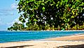
Luquillo Beach, Luquillo
-
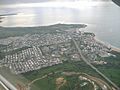
Aerial view of Luquillo


See also
 In Spanish: Luquillo para niños
