Luthersville, Georgia facts for kids
Quick facts for kids
Luthersville, Georgia
|
|
|---|---|
|
City
|
|

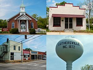
Luthersville in 2013
|
|

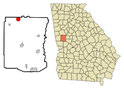
Location in Meriwether County and the state of Georgia
|
|
| Country | United States |
| State | Georgia |
| County | Meriwether |
| Area | |
| • Total | 3.19 sq mi (8.25 km2) |
| • Land | 3.16 sq mi (8.19 km2) |
| • Water | 0.02 sq mi (0.06 km2) |
| Elevation | 942 ft (287 m) |
| Population
(2020)
|
|
| • Total | 776 |
| • Density | 245.26/sq mi (94.70/km2) |
| Time zone | UTC-5 (Eastern (EST)) |
| • Summer (DST) | UTC-4 (EDT) |
| ZIP code |
30251
|
| Area code(s) | 770 |
| FIPS code | 13-48008 |
| GNIS feature ID | 0317494 |
Luthersville is a city in Meriwether County, Georgia, United States. The population was 874 at the 2010 census.
Contents
Geography
Luthersville is located at 33°12′33″N 84°44′43″W / 33.20917°N 84.74528°W (33.209299, −84.745286).
According to the United States Census Bureau, the city has a total area of 3.1 square miles (8.0 km²), of which, 3.1 square miles (8.0 km²) of it is land and 0.32% is water.
Demographics
| Historical population | |||
|---|---|---|---|
| Census | Pop. | %± | |
| 1880 | 179 | — | |
| 1900 | 209 | — | |
| 1910 | 349 | 67.0% | |
| 1920 | 359 | 2.9% | |
| 1930 | 321 | −10.6% | |
| 1940 | 354 | 10.3% | |
| 1950 | 312 | −11.9% | |
| 1960 | 282 | −9.6% | |
| 1970 | 400 | 41.8% | |
| 1980 | 597 | 49.3% | |
| 1990 | 741 | 24.1% | |
| 2000 | 783 | 5.7% | |
| 2010 | 874 | 11.6% | |
| 2020 | 776 | −11.2% | |
| U.S. Decennial Census | |||
2020 census
| Race | Num. | Perc. |
|---|---|---|
| White (non-Hispanic) | 341 | 43.94% |
| Black or African American (non-Hispanic) | 387 | 49.87% |
| Native American | 2 | 0.26% |
| Asian | 8 | 1.03% |
| Other/Mixed | 17 | 2.19% |
| Hispanic or Latino | 21 | 2.71% |
As of the 2020 United States census, there were 776 people, 248 households, and 173 families residing in the city.
See also
 In Spanish: Luthersville para niños

All content from Kiddle encyclopedia articles (including the article images and facts) can be freely used under Attribution-ShareAlike license, unless stated otherwise. Cite this article:
Luthersville, Georgia Facts for Kids. Kiddle Encyclopedia.
