
Lyman County, South Dakota facts for kids
Quick facts for kids
Lyman County
|
|
|---|---|

|
|

Location within the U.S. state of South Dakota
|
|
 South Dakota's location within the U.S. |
|
| Country | |
| State | |
| Founded | 1893 |
| Named for | W. P. Lyman |
| Seat | Kennebec |
| Largest community | Lower Brule |
| Area | |
| • Total | 1,707 sq mi (4,420 km2) |
| • Land | 1,642 sq mi (4,250 km2) |
| • Water | 65 sq mi (170 km2) 3.8% |
| Population
(2020)
|
|
| • Total | 3,718 |
| • Estimate
(2021)
|
3,764 |
| • Density | 2.1781/sq mi (0.8410/km2) |
| Time zone | UTC−6 (Central) |
| • Summer (DST) | UTC−5 (CDT) |
| Congressional district | At-large |
Lyman County is a county located in the U.S. state of South Dakota. As of the 2020 census, the population was 3,718. Its county seat is Kennebec.
Lyman County was created by the Dakota Territorial Legislature on January 8, 1873, but was not organized until May 21, 1893. Its boundaries were altered in 1891, 1897, 1898, and 1916. The county was named for W. P. Lyman, a politician.
Contents
History
Lyman County was created in 1873 and organized in 1893. Oacoma served as its first county seat in 1891; in 1922 the seat was transferred to Kennebec.
Geography
According to the U.S. Census Bureau, the county has a total area of 1,707 square miles (4,420 km2), of which 1,642 square miles (4,250 km2) is land and 65 square miles (170 km2) (3.8%) is water.
Major highways
 Interstate 90
 U.S. Highway 83
 U.S. Highway 183
 South Dakota Highway 47
 South Dakota Highway 49
 South Dakota Highway 53
 South Dakota Highway 273
 South Dakota Highway 1806
Adjacent counties
- Hughes County, South Dakota - north
- Hyde County, South Dakota - northeast
- Buffalo County, South Dakota - northeast
- Brule County, South Dakota - east
- Charles Mix County, South Dakota - southeast
- Gregory County, South Dakota - south
- Tripp County, South Dakota - south
- Mellette County, South Dakota - southwest
- Jones County, South Dakota - west
- Stanley County, South Dakota - northwest
National protected area
- Fort Pierre National Grassland (part)
Demographics
| Historical population | |||
|---|---|---|---|
| Census | Pop. | %± | |
| 1880 | 124 | — | |
| 1890 | 233 | 87.9% | |
| 1900 | 2,632 | 1,029.6% | |
| 1910 | 10,848 | 312.2% | |
| 1920 | 6,591 | −39.2% | |
| 1930 | 6,335 | −3.9% | |
| 1940 | 5,045 | −20.4% | |
| 1950 | 4,572 | −9.4% | |
| 1960 | 4,428 | −3.1% | |
| 1970 | 4,060 | −8.3% | |
| 1980 | 3,864 | −4.8% | |
| 1990 | 3,638 | −5.8% | |
| 2000 | 3,895 | 7.1% | |
| 2010 | 3,755 | −3.6% | |
| 2020 | 3,718 | −1.0% | |
| 2021 (est.) | 3,764 | 0.2% | |
| US Decennial Census 1790-1960 1900-1990 1990-2000 2010-2020 |
|||
2010 census
As of the 2010 United States Census, there were 3,755 people, 1,392 households, and 967 families in the county. The population density was 2.3 inhabitants per square mile (0.89/km2). There were 1,704 housing units at an average density of 1.04 per square mile (0.40/km2). The racial makeup of the county was 58.3% white, 38.2% American Indian, 0.3% Asian, 0.1% black or African American, 0.1% from other races, and 2.9% from two or more races. Those of Hispanic or Latino origin made up 1.1% of the population. In terms of ancestry, 27.3% were German, 9.2% were Irish, 9.1% were Norwegian, and 1.0% were American.
Of the 1,392 households, 35.6% had children under the age of 18 living with them, 47.1% were married couples living together, 15.2% had a female householder with no husband present, 30.5% were non-families, and 27.2% of all households were made up of individuals. The average household size was 2.67 and the average family size was 3.19. The median age was 36.1 years.
The median income for a household in the county was $36,323 and the median income for a family was $45,045. Males had a median income of $32,760 versus $25,512 for females. The per capita income for the county was $16,930. About 17.4% of families and 18.8% of the population were below the poverty line, including 25.4% of those under age 18 and 5.8% of those age 65 or over.
Communities
City
Towns
Census-designated places
Unincorporated community
Townships
The county is divided into sixteen townships:
- Bailey
- Butte
- Dorman
- Fairland
- Iona
- Morningside
- Oacoma
- Pleasant
- Pratt
- Reliance
- Rex
- Rose
- Rowe
- Sioux
- Stony Butte
- Vivian
Unorganized territories
The county contains six areas of unincorporated territory:
- Black Dog
- Lafayette
- Lower Brule
- McClure
- Northwest Lyman
- South Lyman
Images for kids
-
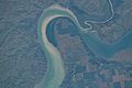
Confluence of the White and Missouri rivers at the Lyman–Brule county border, taken on July 4, 2022 from the International Space Station

See also
 In Spanish: Condado de Lyman para niños
