
M27 motorway facts for kids
Quick facts for kids
|
||||
|---|---|---|---|---|
_map.svg) |
||||
| Route information | ||||
| Length | 27.9 mi (44.9 km) | |||
| Existed | 1972–present | |||
| History | Constructed 1972–83 | |||
| Major junctions | ||||
| West end | Cadnam 50°55′06″N 1°35′35″W / 50.9182°N 1.5930°W |
|||
J3 → M271 motorway J4 → M3 motorway J12 → M275 motorway |
||||
| East end | Portsmouth 50°50′12″N 1°03′54″W / 50.8366°N 1.0650°W |
|||
| Location | ||||
| Primary destinations: |
Southampton, Fareham, Portsmouth, (Ringwood), (Bournemouth), (Salisbury), (Winchester), (Chichester), (Brighton) | |||
| Road network | ||||
|
||||

The M27 is a motorway in Hampshire, England. The main reason it was built was to link the cities of Southampton and Portsmouth. It is not yet finished, and more of it to the east has not been built yet.
Junctions
| M27 motorway junctions | |||||
| miles | km | Westbound exits (B carriageway) | Junction | Eastbound exits (A carriageway) | Coordinates |
|---|---|---|---|---|---|
| 0.0 1.2 |
0.0 2.0 |
Road continues as A31 to The WEST, Ringwood, Bournemouth, Poole, and Dorchester | Terminus J1 |
Cadnam A336, Brook, Bramshaw B3079, Lyndhurst A337 |
50°55′14″N 1°35′22″W / 50.92051°N 1.58958°W |
| The New Forest, Cadnam, Lyndhurst A337 |
Start of motorway | ||||
| 4.2 4.6 |
6.8 7.4 |
Salisbury A36, Fawley A326 | J2 | Salisbury, Romsey A36, Fawley A326, Paultons Park | 50°56′45″N 1°31′46″W / 50.94583°N 1.52950°W |
| 6.6 6.8 |
10.6 11.0 |
Southampton, The Docks M271(S), Romsey M271(N) | J3 | Southampton, The Docks M271 | 50°56′45″N 1°28′35″W / 50.94577°N 1.47637°W |
| Rownhams Services (Roadchef) | Services | Rownhams Services (Roadchef) | 50°57′26″N 1°26′57″W / 50.95732°N 1.44917°W | ||
| 9.4 9.8 |
15.2 15.7 |
The MIDLANDS, London, Winchester M3 | J4 | The MIDLANDS, London, Winchester M3 | 50°57′14″N 1°24′28″W / 50.95394°N 1.40767°W |
| 11.7 11.9 |
18.9 19.2 |
Southampton, Eastleigh, Airport |
J5 | Southampton, Eastleigh, Airport |
50°56′58″N 1°22′16″W / 50.94948°N 1.37115°W |
| Non- exsistent | J6 | 'Non-exsistent' | |||
| 15.5 15.7 |
24.9 25.2 |
Hedge End A334 | J7 | Hedge End, Botley A334 | 50°55′01″N 1°19′03″W / 50.91700°N 1.31763°W |
| 16.2 17.0 |
26.0 27.4 |
Southampton, Hamble, East Docks A3024 | J8 | Southampton (E), Hamble A3024 | 50°53′54″N 1°18′44″W / 50.89838°N 1.31222°W |
| 19.9 20.6 |
32.1 33.1 |
Fareham (W) A27, Whiteley | J9 | Fareham (W) A27, Whiteley | 50°52′28″N 1°15′09″W / 50.87431°N 1.25257°W |
| 23.2 23.5 |
37.4 37.8 |
Alton A32 (No access from A32 to M27) | J10 | No exit | 50°52′00″N 1°10′56″W / 50.86678°N 1.18232°W |
| 24.4 24.7 |
39.2 39.8 |
Fareham (C) A27, Gosport (A32) | J11 | Fareham (C) A27, Gosport (A32) | 50°51′36″N 1°09′27″W / 50.86004°N 1.15760°W |
| 27.7 28.1 |
44.6 45.2 |
Portsmouth, Ferries M275 | J12 | Cosham, Paulsgrove, Hilsea A27, Portsmouth (W), Ferries M275 | 50°50′32″N 1°05′34″W / 50.84213°N 1.09271°W |
| 29.0 | 46.6 | Start of motorway | Terminus | No exit, access to A3 via J12 | 50°55′14″N 1°35′22″W / 50.92051°N 1.58958°W |
| Cosham A3(N), Hilsea A3(S) | Road continues as A27 to Havant, Portsmouth (E), Brighton and London (A3(M)) | ||||
Notes
|
|||||
| 1.000 mi = 1.609 km; 1.000 km = 0.621 mi | |||||
Images for kids
-
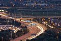
Looking down onto the M27 from Portsdown Hill
-
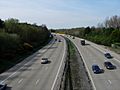
M27 Between junctions 5 and 7 (there is no junction 6)


All content from Kiddle encyclopedia articles (including the article images and facts) can be freely used under Attribution-ShareAlike license, unless stated otherwise. Cite this article:
M27 motorway Facts for Kids. Kiddle Encyclopedia.