
M50 motorway (Great Britain) facts for kids
Quick facts for kids
|
||||
|---|---|---|---|---|
_map.svg) |
||||

The M50, looking south-west from the Ryton Bridge towards Ross-on-Wye
|
||||
| Route information | ||||
| Length | 21.6 mi (34.8 km) | |||
| Existed | 1960–present | |||
| History | Constructed 1958–62 | |||
| Major junctions | ||||
| East end | Strensham | |||
M5 motorway |
||||
| West end | Ross-on-Wye | |||
| Major junctions |
A449 road | |||
| Road network | ||||
|
||||

The M50 is a motorway in South West England. It goes from from the M5 to near Ross-on-Wye. Together with the A40 and A449, it links the West Midlands to South Wales. It is about 22 miles (35 km).
Junctions
| M50 motorway junctions | |||||
| mile | km | Eastbound exits (B carriageway) | Junction | Westbound exits (A carriageway) | Coordinates |
|---|---|---|---|---|---|
| 0.0 | 0.0 | The Midlands, Worcester, Birmingham, The South West, Tewkesbury, Bristol M5 | M5, J8 Terminus |
Start of motorway | 52°02′52″N 2°08′08″W / 52.0477°N 2.1355°W |
| 1.7 | 2.8 | Tewkesbury A38 | J1 | Malvern A38 | |
| 10.9 | 17.5 | Gloucester A417 | J2 | Ledbury A417
Hereford (A438) |
|
| 18.0 | 28.9 | Newent B4221 | J3 | Newent B4221 | |
| 21.6 | 34.7 | Start of motorway | J4 Terminus |
South Wales, Monmouth, Ledbury, Ross-on-Wye A449 | 51°55′49″N 2°33′44″W / 51.9302°N 2.5623°W |
| 1.000 mi = 1.609 km; 1.000 km = 0.621 mi | |||||
Images for kids
-
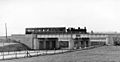
A train using the newly constructed viaduct on the Tewkesbury and Malvern railway – the line was to be dismantled a few years later
-

In Herefordshire the road passes cultivated fields and pastures
-
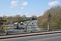
The minor Junction 3 exits, viewed from the adjoining minor road bridge


All content from Kiddle encyclopedia articles (including the article images and facts) can be freely used under Attribution-ShareAlike license, unless stated otherwise. Cite this article:
M50 motorway (Great Britain) Facts for Kids. Kiddle Encyclopedia.