Mabuiag Island facts for kids

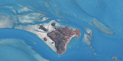
Landsat image of the Bellevue Islands, with Mabuiag in the centre
|
|
| Geography | |
|---|---|
| Location | Arafura Sea |
| Archipelago | Bellevue Islands |
| Total islands | 11 |
| Administration | |
|
Australia
|
|
| State | Queensland |
| Local government area | Torres Strait Island Region |
| Demographics | |
| Population | 251 (2006) |
| Ethnic groups | Mabuiag people |
| Mabuiag Island Queensland |
|||||||||||||||
|---|---|---|---|---|---|---|---|---|---|---|---|---|---|---|---|
| Population | 210 (2016 census) | ||||||||||||||
| • Density | 33.3/km2 (86/sq mi) | ||||||||||||||
| Postcode(s) | 4875 | ||||||||||||||
| Area | 6.3 km2 (2.4 sq mi) | ||||||||||||||
| Time zone | AEST (UTC+10:00) | ||||||||||||||
| Location |
|
||||||||||||||
| LGA(s) | Torres Strait Island Region | ||||||||||||||
| State electorate(s) | Cook | ||||||||||||||
| Federal Division(s) | Leichhardt | ||||||||||||||
|
|||||||||||||||
Mabuiag (also known as "Mabuyag", formerly "Jervis Island") is one of the Torres Strait Islands in Queensland, Australia. Mabuiag Island is also a town and locality in the Torres Strait Island Region local government area. In the 2016 census, Mabuiag Island had a population of 210 people.
Contents
Geography
The island is in the Bellevue Islands group, 100 kilometres (62 mi) north of Thursday Island in the Napoleon Passage and Arnolds Passage of the Torres Strait. It has other traditional names as well, such as Gumu (strictly speaking the name of the South-East part of Mabuiag).
This island is one of the Torres Strait Islands, originally named by Captain William Bligh, "Jervis Island", and so labelled on early English language maps.
History
Archaeological excavations have shown that people arrived on Mabuiag at least 7300 years ago. During this period, Islanders were able to survive by fishing and hunting dugong. The island continued to be occupied by small communities for the subsequent 5000 years, with pottery (usually associated with Melanesian peoples) found at two sites, Mui (East coast of Mabuiag) and Mask Cave (on adjacent islet, Pulu) dating from approximately 2000 years ago. The past 1000 years witnessed expansion in site use, including formation of multiple ethnographically-significant 'villages', including Goemu, Wagadagam and Dabangay. During the past 400–500 years large, highly structured mounds of dugong bone, as well as shell and stone arrangements provide evidence for emerging totemic divisions
The "Footprints before me – Torres Strait Island Missions and Communities" webpage tells the following history of Mabuiag Island and the people living there
Kala Lagaw Ya (also known as Kala Lagaw Ya, KLY and Gumulgaw Ya) is one of the languages of the Torres Strait. Kala Lagaw Ya is the traditional language owned by the Western and Central islands of the Torres Strait. The Kala Lagaw Ya language region includes the landscape within the local government boundaries of the Torres Shire Council.
Mabuiag is considered a dialect of Kala Lagaw Ya, one of the languages of the Torres Strait. Mabuiag (also written as Mabuyag) is the traditional language of Mabuiag and Badu, Central Western islands of the Torres Strait. The Mabuiag language region includes the island landscape of Mabuiag within the local government boundaries of the Torres Shire Council and Mabuiag Island Council.
In 1606, Luís Vaz de Torres sailed through, and navigated, Torres Strait islands, along New Guinea's southern coast.
"The Mabuiag people had a reputation for hostility to outsiders until their acceptance of Christianity in the early 1870s. In 1877 the mission moved to Bau where the water supply was better. Later, the missionaries persuaded the people to join them at Bau, which became the main settlement. By 1898, Mabuiag people were labouring on pearling luggers for wages, while many followed work to Thursday Island and further to the mainland. An official presence on Mabuiag began during the mid-1920s when Queensland Government posted teachers there. An Island Industries Board store opened in 1946".
Mabuiag Island State School opened on 29 January 1985. On 1 January 2007 the school became the Maubuiag Island campus of Tagai State College, an amalgamation of 17 Torres Strait Island schools.
Transportation
The island is one of the only ones in the Strait to have an airport, though its runway is the smallest in Australia to have commercial service. The runway as Mabuiag Island Airport is only 390 metres long.
Amenities
The Torres Strait Islands Regional Council operates an Indigenous Knowledge Centre with public library facilities on Main Street, known as Ngalpun Ngulaygaw Lag Resource Centre 'Our Place of Learning'.
Education
Tagai State College has 17 campuses throughout the Torres Strait. Its Mabuiag Island campus (Mabuygiw Ngurpay Lag) provides primary (Early Childhood-6) education at School Street (9°57′17″S 142°11′22″E / 9.9546°S 142.1895°E).
There is no secondary school on the island. The nearest secondary school is on Thursday Island.


