
Madeira Islands facts for kids
Quick facts for kids Madeira |
|||
| Autonomous Region (Região Autónoma) | |||
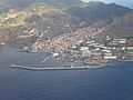
 A view of Funchal, the capital city of Madeira.
|
|||
|
|||
| Official name: Região Autónoma da Madeira | |||
| Name origin: madeira, Portuguese for wood | |||
| Motto: Das ilhas, as mais belas e livres (Of all islands, the most beautiful and free) |
|||
| Nickname: Pérola do Atlântico (Pearl of the Atlantic) |
|||
| Country | |||
|---|---|---|---|
| Autonomous Region | |||
| Region | Atlantic Ocean | ||
| Subregion | Tore-Madeira Ridge | ||
| Position | Madeira Platform, Savage Islands submarine mount |
||
| Islands | Madeira, Porto Santo, Desertas, Selvagens | ||
| Municipalities | Calheta, Câmara de Lobos, Funchal, Machico, Ponta do Sol, Porto Moniz, Porto Santo, Ribeira Brava, Santa Cruz, Santana, São Vicente | ||
| Capital & largest city | Funchal | ||
| - coordinates | 32°39′4″N 16°54′35″W / 32.65111°N 16.90972°W | ||
| Highest point | Pico Ruivo | ||
| - location | Paul da Serra, Santana, Madeira | ||
| - elevation | 1,862 m (6,109 ft) | ||
| - coordinates | 32°45′31″N 16°56′32″W / 32.75861°N 16.94222°W | ||
| Lowest point | Sea level | ||
| - location | Atlantic Ocean | ||
| - elevation | 0 m (0 ft) | ||
| Area | 801 km² (309 sq mi) | ||
| Population | 267,785 (2011) |
||
| Density | 334 /km² (865 /sq mi) | ||
| Settlement | c. 1420 | ||
| - Administrative autonomy | c. 1895 | ||
| - Political autonomy | 4 September 1976 | ||
| Discovery | c. 1415 | ||
| President | Alberto João Jardim (PPD-PSD) | ||
| - President (Assembleia) | José Miguel Jardim d´Olival de Mendonça (PPD-PSD) | ||
| Timezone | WET (UTC+0) | ||
| - summer (DST) | WEST (UTC+1) | ||
| ISO 3166-2 code | PT-30 | ||
| Postal code | 9XXX-XXX | ||
| Area code | (+351) 291 XXX XXX | ||
| ccTLD | .pt | ||
| Date format | dd-mm-yyyy | ||
| Drive | right-side | ||
| Demonym | Madeiran; Madeirense | ||
| Patron Saint | Nossa Senhora do Monte | ||
| Holiday | 1 July | ||
| Anthem | [A Portuguesa] Error: {{Lang}}: text has italic markup (help) (national) [Hino da Madeira] Error: {{Lang}}: text has italic markup (help) (regional) |
||
| Currency | Euro (€) | ||


Madeira is a Portuguese archipelago that lies between 32°22.3′N 16°16.5′W / 32.3717°N 16.2750°W and 33°7.8′N 17°16.65′W / 33.1300°N 17.27750°W, just under 400 kilometres (250 mi) north of Tenerife, Canary Islands, in the north Atlantic Ocean and an outermost region of the European Union.
The archipelago comprises the major part of one of the two autonomous regions of Portugal (the other being the Azores located to the northwest), that includes the islands of Madeira, Porto Santo, and the Desertas, administered together with the separate archipelago of the Savage Islands.
The name Madeira could be used for the autonomous region, the geographical group of islands or just the island of Madeira. These islands are part of the Macaronesia.
Contents
History
Discovery
Madeira's official written history began in 1418, when two captains under service to Prince Henry the Navigator, João Gonçalves Zarco and Tristão Vaz Teixeira, were pushed by a storm to an island which they named Porto Santo (English: holy harbour). The following year, an organised expedition was sent to this new land to take possession of the island on behalf of the Portuguese crown. Later, the new settlers saw an island to the southwest, and so the larger island of Madeira was discovered.
Settlement
The islands were found to be completely uninhabited, and their colonization by the Portuguese began around 1420 or 1425. To get the minimum conditions for the development of agriculture, they had to cut part of the dense forest and to construct a large number of canals (levadas) to carry water, since in some parts of the island there was excess water, while in others water was scarce. During this period, fish constituted about half of the settlers' diet, together with vegetables and fruits cultivated from small pieces of land. Initially, these colonists produced wheat for their own subsistence, but later the quantity cultivated was sufficient to begin sending wheat to continental Portugal.
On the 23 September of 1433, the name Ilha da Madeira (English: Madeira Island, or literally island of wood) began to appear in the first documents and maps. The name given to the islands corresponded to the large dense forests of native trees that covered the island.
However, when wheat production began to fall, the crisis forced to plant other commercial crops. They brought from Sicily plants of sugarcane to produce sugar. After the 17th century, as sugar production went to Brazil, São Tomé and Príncipe and elsewhere, Madeira's most important product became its wine.
Geography
As other islands of the Macaronesia, the Madeira islands are of volcanic origin and with a subtropical climate.
Location
The archipelago is in the African plate, in the Atlantic Ocean between the latitudes 30° and 33° north, 978 km (608 mi) southwest of Lisbon and, about 700 km (435 mi) west of the African coast, almost at the same latitude as Casablanca.
Islands and islets
The Madeira islands have a total area of 801 km2 (309 sq mi). Their individual areas vary between 740.7 km2 (286.0 sq mi) of the largest island (Madeira) to 3.6 km2 (1.4 sq mi) of the Savage Islands.
| Island | Area (km2) |
Islets (Portuguese: Ilhéu) |
|---|---|---|
| Madeira | 740.7 | Ilhéu de Agostinho, Ilhéu de São Lourenço, Ilhéu Mole |
| Porto Santo | 42.5 | Ilhéu de Baixo ou da Cal, Ilhéu de Ferro, Ilhéu das Cenouras, Ilhéu de Fora, Ilhéu de Cima |
| Desertas Islands | 14.2 | Deserta Grande, Bugio Island, Ilhéu de Chão |
| Savage Islands | 3.6 | |
| Northwest Group | Selvagem Grande, Ilhéu de Palheiro da Terra, Ilhéu de Palheiro do Mar | |
| Southeast Group | Selvagem Pequena, Ilhéu Grande, Ilhéu Sul, Ilhéu Pequeno, Ilhéu Fora, Ilhéu Alto, Ilhéu Comprido, Ilhéu Redondo, Ilhéu Norte | |
Of the eight islands, only the two largest (Madeira and Porto Santo) are inhabited, having as main accesses, the Madeira Airport in Funchal and the one in Porto Santo. By sea, Funchal has a port that receives different ships, especially cruise ships. The remaining islands are nature reserves.

Territory
The territory of the archipelago contains two main islands: the islands of Madeira and Porto Santo; besides these, there are two groups of uninhabited islands, the Desertas and Savages.
The island of Madeira has a very irregular and uneven terrain, being the highest points the peaks Pico Ruivo (1862 m), Pico das Torres (1851 m), Pico do Ariero (1818 m) and Pico do Juncal (1800 m). The northern coast is dominated by high cliffs.
The island of Porto Santo, on the other hand, has a completely different geomorphological formation of the island of Madeira. It is very flat where only small plants grow and the soils are poor and not very good for agriculture. This island has some peaks, particularly in the north, and the Pico do Facho (517 m) is the highest point of elevation in the island, followed by Pico Branco (450 m).
The highest point of Desertas Islands is Pedregal (442 m) in Deserta Grande, and of Selvagens Islands is Pico da Atalaia (153 m), in Selvagem Grande.
Climate

The average temperature for the year in Funchal, Madeira island, is 19°C (66.2°F). The warmest month, on average, is August with an average temperature of 22.6°C (72.7°F). The coolest month on average is February, with an average temperature of 16.1°C (61.0°F).
The average amount of precipitation for the year in Funchal is 596.9 mm (23.5"). The month with the most precipitation on average is December with 109.2 mm (4.3") of precipitation. The month with the least precipitation on average is July with an average of 2.5 mm (0.1"). There are an average of 87 days of precipitation, with the most precipitation occurring in December with 13 days and the least precipitation occurring in July with 1 days.
For the Villa de Porto Santo, Porto Santo island, the average temperature for the year is 17.8°C (64.0°F). The warmest month, on average, is August with an average temperature of 21.7°C (71.0°F). The coolest month on average is January, with an average temperature of 15°C (59.0°F).
The average amount of precipitation for the year in Villa de Porto Santo is 375.9 mm (14.8"). The month with the most precipitation on average is January with 61 mm (2.4") of precipitation. The month with the least precipitation on average is July with an average of 2.5 mm (0.1").
The Köppen climate classification subtype for this climate of Funchal (Madeira) and Villa de Porto Santo (Porto Santo) is Csb (Mediterran Climate).
The climate of Desertas islands and partes of Porto Santo is semi-arid (Bs) and in the Savage islands is a desert climate (Bw).
| Climate data for Madeira : Funchal | |||||||||||||
|---|---|---|---|---|---|---|---|---|---|---|---|---|---|
| Month | Jan | Feb | Mar | Apr | May | Jun | Jul | Aug | Sep | Oct | Nov | Dec | Year |
| Average high °C (°F) | 19.2 (66.6) |
19.3 (66.7) |
19.8 (67.6) |
19.9 (67.8) |
20.9 (69.6) |
22.6 (72.7) |
24.4 (75.9) |
25.8 (78.4) |
25.9 (78.6) |
24.4 (75.9) |
22.4 (72.3) |
20.4 (68.7) |
22.1 (71.8) |
| Average low °C (°F) | 15.9 (60.6) |
13.2 (55.8) |
13.3 (55.9) |
13.8 (56.8) |
14.9 (58.8) |
16.9 (62.4) |
18.4 (65.1) |
19.4 (66.9) |
19.4 (66.9) |
18.0 (64.4) |
16.1 (61.0) |
14.5 (58.1) |
15.9 (60.6) |
| Average precipitation mm (inches) | 90.6 (3.57) |
64.5 (2.54) |
56.2 (2.21) |
37.8 (1.49) |
30.3 (1.19) |
6.4 (0.25) |
2.8 (0.11) |
3.1 (0.12) |
34.7 (1.37) |
78.2 (3.08) |
82.4 (3.24) |
109.4 (4.31) |
596.4 (23.48) |
| Source: Weatherbase.com [1] | |||||||||||||
Administration
In 1976 Madeira became one of the two autonomous regions of the Republic of Portugal (Azores is the other) under the Portuguese name Região Autónoma da Madeira, with its own executive and a regional legislature. The current president of the regional government is Alberto João Jardim. The main offices of the regional government are in Funchal, making this city the capital of the region.
Administrative divisions

Administratively, the Autonomous Region of Madeira (with a population of 267,785 inhabitants in 2011 and covering an area of 801.0 km2 (309.3 sq mi)) is organised into 11 municípios, of which 10 are in the island of Madeira and one in Porto Santo. Municipalities are further divided into 54 freguesias, 53 in Madeira and 1 in Porto Santo.
| Municipality | Population (2011) |
Area (km2) |
Main settlement | Parishes (Freguesias) |
|---|---|---|---|---|
| Calheta | 11,521 | 111.5 | Calheta | 8 |
| Câmara de Lobos | 35,666 | 52.1 | Câmara de Lobos | 5 |
| Funchal | 111,892 | 76.1 | Funchal | 10 |
| Machico | 21,828 | 68.3 | Machico | 5 |
| Ponta do Sol | 8,862 | 46.2 | Ponta do Sol | 3 |
| Porto Moniz | 2,711 | 82.9 | Porto Moniz | 4 |
| Porto Santo | 5,483 | 42.6 | Vila Baleira | 1 |
| Ribeira Brava | 13,375 | 65.4 | Ribeira Brava | 4 |
| Santa Cruz | 43,005 | 81.5 | Santa Cruz | 5 |
| Santana | 7,719 | 95.6 | Santana | 6 |
| São Vicente | 5,723 | 78.8 | São Vicente | 3 |
| Total | 267,785 | 801.0 | 54 |
Population
According to the 2011 Census, the total population in the Autonomous Region of Madeira was 267,785: 126,268 men and 141,517 women. The density for the whole region is 334.3 persons/km2; calculating the density taking in account only the inhabited islands (Madeira and Porto Santo), the density would be 341.9 inhabitants/km2.
Nature


The region of Madeira is home to a great and important biodiversity, with an estimated 7,571 terrestrial species for the whole archipelago. The total number of endemic species and subspecies is about 1,419 (1,286 species and 182 sub-species), which represents 19% of the overall species diversity.
The most known environment of the archipelago is its Laurel forest (laurisilva) which still extends over 15,000 hectares or 20% of the archipelago. These forests, very rich in biodiversity, are the largest and best-preserved Laurel forests in the entire Macaronesia region. They are home to unique plant and animal species, including the famous Trocaz Pigeon or Madeira Laurel Pigeon (Columba trocaz), and the Madeira Kinglet (Regulus madeirensis). The most threatened bird of Europe, the Madeiran or Zino’s Petrel (Pterodroma madeira) inhabits the highest cliffs in the Central Mountainous Massif of the Madeira island.
In the sea around Madeira there are numerous species of marine mammals, including 28 species of cetaceans and the critically endangered Mediterranean Monk Seal (Monachus monachus).
There are 6 protected areas in the Madeira Archipelago, including the Madeira Natural Park. This park, which covers over 2/3 of Madeira Island and includes the entire Laurel forest, is a European Council Biogenetic Reserve since 1992, and a UNESCO World Natural Heritage Site since 1999. Additionally, 11 sites in the whole archipelago are part of the Natura 2000 network and 11 other sites are designated Important Bird Areas.
Economy
The local economy is based mainly on agriculture and tourism, the main resource. Agriculture produces bananas, flowers, and Madeira wine which is exported. The industrial area is not very diverse and they are relationated with food, beverages, tobacco and construction.
Images for kids
-
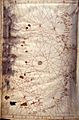
The fourth and final sheet of the four-sheet Corbitis Atlas (1384-1410)
-
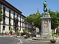
Statue of João Gonçalves Zarco
-
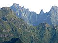
Sights from Bica da Cana showing Madeira's high orography
-
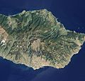
Detailed, true-colour image of Madeira. The image shows that deep green laurel forest (laurissilva) survives intact on the steep northern slopes of the island, but in the south, where terrain is gentler, the terracotta colour of towns and the light green colour of agriculture are more dominant
-
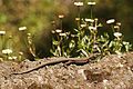
Madeiran wall lizard (Teira dugesii) captured in Levada do Norte, Madeira
-
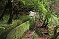
Levada near Rabaçal
-
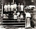
Many Portuguese immigrants in Hawaii were Madeiran
-
Caniçal on the left and Madeira Free Trade (Industrial) Zone on the right
-
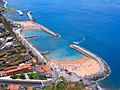
Calheta Beach
-
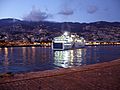
A ferry makes daily trips between Madeira and Porto Santo.
-
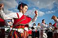
Bailinho da Madeira
-
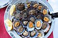
"Lapas", the true limpet species Patella vulgata
-
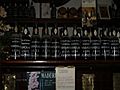
Bottles of Madeira labelled by the different grape varieties used to produce the many styles of wine
-
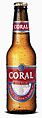
Coral Beer, produced since 1872 in the Island's main brewery, has achieved several Monde Selection medals
-
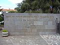
Monument in Camacha, celebrating the first ever organised football game in Portugal
.jpg)
13.jpg)


.jpg)


See also
 In Spanish: Madeira para niños
