
Maipo (volcano) facts for kids
Quick facts for kids MaipoMaipu |
|
|---|---|

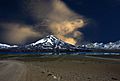
Maipo volcano and its lake
|
|
| Highest point | |
| Elevation | 5,264 m (17,270 ft) |
| Prominence | 1,989 m (6,526 ft) |
| Geography | |
|
Lua error in Module:Location_map at line 420: attempt to index field 'wikibase' (a nil value).
|
|
| Location | Argentina – Chile |
| Parent range | Andes |
| Geology | |
| Mountain type | Stratovolcano |
| Last eruption | 1912 |
| Climbing | |
| First ascent | 1883 |
| Easiest route | snow/ice climb |
Maipo is a stratovolcano in the Andes, lying on the border between Argentina and Chile. It is located 90 km (56 mi) south of Tupungato, one of the highest mountains in the Americas, and about 100 km (62 mi) southeast of Santiago.
Contents
History
The first ascent of this peak was made on 19 January 1833 by Paul Güssfeldt, a German geologist, mountaineer and explorer, together with two Chilean guides: Lorenzo Zamorano and Francisco (only the first name is known).
Geography
In Chile, the Maipo volcano is in the Santiago Metropolitan Region, Cordillera province, San José de Maipo commune. In Argentina, it is in the Mendoza province, San Carlos department, Pareditas district.
The Maipo river starts on the western side (Chile) of the volcan. The Diamante river start on the eastern side (Argentina) in the lake with the same name.
The volcano was formed during the Pleistocene. There are four historical and confirmed records of eruptions of the Maipo: in 1826, 1829,1905 and 1912. The Laguna del Diamante ("Diamond Lake") was formed by the eruption of 1826.
Gallery
-
Maipo volcano
-
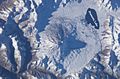
Satellite image of the Maipo
-
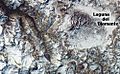
Satellite image of the Maipo


Related pages
See also
 In Spanish: Volcán Maipo para niños
