
Mangoplah facts for kids
Quick facts for kids MangoplahNew South Wales |
|
|---|---|

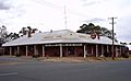
Mangoplah Hall
|
|

Mangoplah
Location in New South Wales
|
|
| Population | 309 (2016 census) |
| Established | 1850's |
| Postcode(s) | 2652 |
| Elevation | 276 m (906 ft) |
| Time zone | AEST (UTC+10) |
| • Summer (DST) | AEST (UTC+11) |
| Location |
|
| LGA(s) | City of Wagga Wagga |
| County | Mitchell |
| State electorate(s) | Wagga Wagga |
| Federal Division(s) | Riverina |
Mangoplah is a town approximately 36 kilometres (22 mi) south of Wagga Wagga in the Riverina region of New South Wales, Australia. At the 2016 census, Mangoplah had a population of 309. The name of the town is believed to mean "Kooris singing" in the Wiradjuri aboriginal language.
History
Mangoplah Post Office opened on 1 September 1880, closed in 1885 and reopened in 1911.
A hotel and grain silo was built in 1923, and a railway station operated in the town from 1925 until 1956 - a bushfire in 1952 forced its closure.
Mangoplah was formerly within the Shire of Kyeamba until 1 January 1981 when the Shire was amalgamated with the Shire of Mitchell into the City of Wagga Wagga.
Today
The town contains a pub, hall, two churches, a general store and a rural produce distributor. The primary school in Mangoplah operated until its closure in 2013. The local Australian rules football team is the Mangoplah Cookardinia United-Eastlakes Football Club. The official mascot for the club is the goanna. The three football grades and the netball teams compete in the Riverina Football League.
Mangoplah is located 10 kilometres (6.2 mi) west of Livingstone National Park.
Images for kids
-
Mangoplah Hotel

