
Manila facts for kids


Manila is the capital city of the Philippines. It is one of the largest cities in the Philippines. Manila is on the biggest island of the Philippines, Luzon. Manila is by a bay named Manila Bay. The metropolitan area is much larger. It stretches across a thin strip of land to a lake called "Laguna de Bay".
Contents
History
Prehistory
The earliest evidence of human habitation in and around the area of Manila is found the via the nearby Angono Petroglyphs dated to around 3000 BC. Furthermore, negritos, a class of Australoid peoples, became the aboriginal inhabitants of the Philippine islands. They were found across Luzon before the Malayo-Polynesians migrated in and assimilated them.
Indian influence

Manila was first known as Gintô (gold) or Suvarnadvipa by neighboring settlements and was officially named as the Kingdom of Maynila. The Kingdom flourished during the latter half of the Ming Dynasty as a result of direct trade relations with China. Ancient Tondo was maintained as the traditional capital of the empire, with its rulers as sovereign kings and not mere chieftains, and were addressed variously as panginuan or panginoon ("lords"); anak banwa ("son of heaven"); or lakandula ("lord of the palace"), the Emperor of China considered the Lakans (rulers of ancient Manila) "王" (Kings). In the 13th century, the city consisted of a fortified settlement and trading quarter at the shores of the Pasig River, on top of previous older towns. Manila was then invaded by the Indianized empire of Majapahit as referenced in the epic eulogy poem Nagarakretagama which inscribed its conquest by Maharaja Hayam Wuruk. Selurong "षेलुरोन्ग्" which is a historical name for the city of Manila is listed in Canto 14 alongside Sulot, which is now Sulu, and Kalka.
Islamic kingdom
During the reign of Sultan Bolkiah from 1485 to 1521, the Sultanate of Brunei attempted to break Tondo's monopoly in the China trade by attacking it and establishing the state of كوتا سلودوڠ Kota Saludong (now Manila) as a Bruneian satellite state. A new dynasty under the islamized rajah, Salalila, was also established to challenge the House of Lakandula in Tondo. Islam was further strengthened by the arrival of traders and proselytizers from Malaysia and Indonesia. Manila was temporarily besieged by the invasion of Chinese pirate-warlord Limahong1574 before it became the seat of the colonial government of Spain,in 1603 Spanish forces in Manila massacred about 26 000 Chinese residents of Manila because Spanish military thought Chinese residents in Manila might have wanted to help Ming 's invasion of Manila .
Viceroyalty of New Spain
On June 24, 1571, Spanish conquistador Miguel López de Legazpi arrived from New Spain, now Mexico, and then exercised rule of the Spanish city of Manila as a territory of New Spain with the establishment of a city council in what today is the district of Intramuros. Miguel López de Legazpi executed the local royalty after the failure of the Tondo Conspiracy; a plot wherein an alliance between Japanese merchants, Luzon's Rajahs with several Visayan Datus plus the Brunei Sultanate would band together to massacre the Spaniards along with their Amerindian mercenaries and African slaves. At the conclusion of which, and after Spanish have massacred about 26000 Chinese residents of Manila in 1603, the victorious Spaniards made Manila the capital of the Spanish East Indies and of the Philippine Islands, which the empire would control for the next three centuries, from 1565 to 1898.
Manila then became famous during the Manila-Acapulco Galleon trade which lasted for three centuries and brought goods from Europe, Africa and Latin America across the Pacific Islands to Southeast Asia (Which was already an entrepot for goods coming from India, Indonesia and China) and trade also flowed vice versa. Silver that was mined in Mexico and Peru were exchanged for Chinese silk, Indian gems, and the spices of the Southeast Asia, some of which even flowed to Europe. Likewise wines and olives grown from Europe and North Africa were transshipped via Mexico towards Manila.
British Occupation
The city was occupied by Great Britain for two years from 1762 to 1764 as part of the European Seven Years' War between Spain and France and Great Britain. The city remained the capital of the Philippines under the government of the provisional British governor, Dawsonne Drake, acting through the Mexico-born Archbishop of Manila, Manuel Rojo del Rio y Vieyra and the captive Audiencia Real. However, armed resistance to the British persisted, centered in Pampanga, and was led by Oidor Don Simón de Anda y Salazar. During the course of the occupation, the captive Hashemite Sultan of Sulu, Azim ud-Din I, was used as a hostage by both the British and Spanish. Also, the Chinese at Binondo rebelled against Spain and afterwards, the British's Sepoy mercenaries from India, mutinied against them. Eventually, the British withdrew as per agreements in the Treaty of Paris (1763). The Sepoys however, elected to stay and they settled in the area around Cainta, Rizal. As for the Chinese, thereafter, the Spanish Fortress-city of Intramuros always pointed their cannons against Binondo (The world's oldest Chinatown) to create a quick response against anymore Chinese uprisings.
Direct Spanish Rule
After the British Occupation, direct trade and communications with Spain facilitated by the opening of the Suez Canal, supplanted indirect rule via the Viceroyalty. Eventually, Mexican Independence necessitated direct rule from Spain. Under direct Spanish rule, banking, industry and education flourished more than in the past two centuries.
The growing wealth and education attracted Indian, Chinese, Latino, European and local migrants from the Philippine provinces to Manila, all of whom elected a nascent Filipino nationality regardless of ethnicity. The developments also facilitated the rise of an illustrado class which espoused liberal ideas, the ideological foundations of the Philippine Revolution which sought independence from Spain. Eventually, developments were so comprehensive, that by the time of First Philippine Republic, the Philippines' GDP per capita rivaled that of Japan.
American Colonial Period

In 1898, after its defeat in the Spanish-American War, Spain ceded the Philippines to the United States, as well as several other territorial possessions, as part of the terms of the Treaty of Paris and a monetary exchange of $20 million. Immediately after liberation from Spain, between 1899 and 1902, Filipino revolutionaries would be involved in armed conflict with the American military in the Philippine–American War and would result in the deaths of as many as 1.5 million Filipino civilians and the dissolution of the First Philippine Republic mainly due to the efforts of general Arthur MacArthur. He succeeded in capturing president Emilio Aguinaldo even after the African-American David Fagen, joined the righteous Filipinos, thus ending the war. Nevertheless, the Philippine republic was still resurrected after World War II.
Until then, they were under American control. A new civilian oriented Insular Government headed by then Governor-General William Howard Taft invited city planner Daniel Burnham for the transformation of Manila, to adapt the old city to changed times and modern needs. The Burnham Plan included development of the road system, the use of waterways for transportation, and beautification of Manila with the improvement of waterfronts, construction of parks, parkways and various building for various activities. The latter included a government center occupying all of Wallace Field, which extends from Luneta to the present Taft Avenue. The Philippine Capitol was to rise at the Taft Avenue end of the field, facing toward the sea, and would form, with the buildings of different government bureaus and departments, a quadrangle, lagoon in the center, and a monument to Jose Rizal at its Luneta end. Of Burnham’s proposed government center, only three units — the Legislative Building and the building of the Finance and Agricultural departments — were completed when World War II erupted.
Japanese Invasion

Due to the Japanese occupation of the Philippines, American soldiers were ordered to withdraw from the city and all military installations were removed on December 24, 1941. General Douglas MacArthur declared Manila an open city to prevent further death and destruction; despite this, the Japanese warplanes continued to bomb the city. Manila was occupied by the Japanese forces on January 2, 1942.
Manila was also the site of the bloodiest battle in the Pacific theater during the Second World War. After falling to the Empire of Japan on January 2, 1942, it was recaptured by joint American and Filipino troops from February 3 to March 3, 1945. Some 100,000 civilians were killed in Manila in February 1945. It was the second most devastated city in the world after Warsaw during the Second World War. At the end of World War II, almost all of the structures in the city, particularly Intramuros, were destroyed but after the war, reconstruction took place.
Sovereign Philippines
In 1948, President Elpidio Quirino moved the seat of government of the Philippines to Quezon City, a new capital city in the suburbs and fields northeast of Manila, created in 1938 by former President Manuel L. Quezon, which was renamed after him. The move ended any implementation of the Burnham Plan's intent for the government centre to be at Luneta.
With Arsenio Lacson as its first elected mayor in 1952 (all mayors were appointed prior to this), the city of Manila underwent The Golden Age, was revitalized, and once again became the "Pearl of the Orient", a moniker it earned before the Second World War. After Mayor Lacson's term in the 1950s, the city was led by Antonio Villegas during most of the 1960s, and Ramon Bagatsing for nearly the entire decade of the 1970s until the 1986 People Power Revolution, making him the longest serving Mayor of Manila. Mayors Lacson, Villegas, and Bagatsing are often collectively considered as the "Big Three of Manila" less for their rather long tenures as the city's chief executive (continuously for over three decades, from 1952–1986), but more for their indelible contribution to the development and progress of the city and their lasting legacy in uplifting the quality of life and welfare of the people of the city of Manila.
During the dictatorship of President Ferdinand Marcos, the region of the Greater Manila Area was created as an integrated unit with the enactment of Presidential Decree No. 824 on November 7, 1975. The area encompassed four cities and thirteen adjoining towns, as a separate regional unit of government. On the 405th anniversary of the city's foundation on June 24, 1976, Manila was reinstated by Marcos as the capital of the Philippines for its historical significance as the seat of government since the Spanish Period. Presidential Decree No. 940 states that Manila has always been to the Filipino people and in the eyes of the world, the premier city of the Philippines being the center of trade, commerce, education and culture.
Geography


Manila is located on the eastern shores of Manila bay, which rests on the western shores of Luzon. The city lies 800 miles (1,300 kilometers) from mainland Asia. The Pasig River bisects the city. Almost all of Manila sits on top of centuries of prehistoric alluvial deposits built by the waters of the Pasig and on some land reclaimed from Manila Bay. The city's land has been altered substantially by human intervention, with considerable land reclamation along the waterfronts since the American colonial times. Some of the natural variations in topography have been evened out due to the urbanization of the city. As of 2007, the city has a land area of 24.98 square kilometres (9.64 sq mi) and has a total area of 38.55 square kilometres (14.88 sq mi).
Manila sits astride the Pacific typhoon belt and is criss-crossed by several fault lines. This led to Manila and its metropolitan region to be ranked as the second riskiest capital (city) to live in according to Swiss Re. The seismically active Marikina Valley Fault System poses a threat to Manila and the surrounding regions. Manila endured several deadly earthquakes, notably in 1645 and in 1677 which destroyed the stone and brick medieval city. The Earthquake Baroque style was used by the Colonial architects during the Spanish colonial period in order to adapt to the frequent earthquakes.
Climate
Under the Köppen climate classification system, Manila features a tropical savanna climate (Köppen climate classification Aw). Together with the rest of the Philippines, Manila lies entirely within the tropics. Its proximity to the equator means that the temperature range is very small, rarely going below 20 °C (68 °F) or above 38 °C (100 °F). Temperature extremes have ranged from 14.5 °C (58.1 °F) on January 11, 1914 to 38.6 °C (101.5 °F) on May 7, 1915.
Cityscape

Architecture

Manila has architecturally significant buildings in a wide range of styles spanning distinct historical and cultural periods. Architectural styles reflect American, Spanish, Chinese, and Malay influences. Architects such as Antonio Toledo and Juan M. Arellano designed some significant buildings in Manila. Works of Arellano includes the Manila Metropolitan Theater and the Manila Central Post Office Buildings, while Antonio Toledo designed the Manila City Hall.
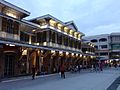
Manila is architecturally known for its Art Deco theaters which are designed by National Artists such as Juan Nakpil and Pablo Antonio. The historic Escolta Street in Binondo features many buildings of neo-classical and beaux-arts architectural style, some of which were designed by prominent Filipino architects in the 1920s to the late 1930s. At present, many architects, artists, historians and heritage advocacy groups are pushing for the revival of Escolta Street, which was once the premier street of the Philippines.
Since Manila is prone to earthquakes, the Spanish colonial architects invented the style called Earthquake Baroque which the churches and government buildings during the Spanish colonial period adopted. As a result, succeeding earthquakes of the 18th and 19th centuries barely affected Manila, although it did periodically level the surrounding area. Modern buildings in and around Manila are designed or have retrofitted to withstand an 8.2 magnitude quake in accordance to the country's building code.
Demographics

According to the 2020 census, the population of the city was 1,846,513, making it the second most populous city in the Philippines. Manila is the most densely populated city in the world, with 41,515 inhabitants per km2 in 2015. District 6 is listed as being the most dense with 68,266 inhabitants per km2, followed by District 1 with 64,936 and District 2 with 64,710. District 5 is the least densely populated area with 19,235.
Manila has been presumed to be the Philippines' largest city since the establishment of a permanent Spanish settlement with the city eventually becoming the political, commercial and ecclesiastical capital of the country. Since colonial times, Manila has been the destination of peoples whose origins are as wide-ranging as India and Latin-America. In the 1860s to 1890s, in the urban areas of the Philippines, especially at Manila, according to burial statistics, as much as 3.3% of the population were pure European Spaniards and the pure Chinese were as high as 9.9% of the people. The Spanish-Filipino and Chinese-Filipino Mestizo populations also fluctuated. Eventually, everybody belonging to these non-native categories diminished because they were assimilated into and chose to self-identify as pure Filipinos since during the Philippine Revolution, the term "Filipino" included anybody born in the Philippines coming from any race. That would explain the abrupt drop of otherwise high Chinese, Spanish and mestizo, percentages across the country by the time of the first American census in 1903. Manila's population increased dramatically since the 1903 census as the population tended to move from rural areas to towns and cities. In the 1960 census, Manila became the first Philippine city to breach the one million mark (more than 5 times of its 1903 population). The city continued to grow until the population somehow "stabilized" at 1.6 million and experienced alternating increase and decrease starting the 1990 census year. This phenomenon may be attributed to the higher growth experience by suburbs and the already very high population density of city. As such, Manila exhibited a decreasing percentage share to the metropolitan population from as high as 63% in the 1950s to 27.5% in 1980 and then to 13.8% in 2015. The much larger Quezon City marginally surpassed the population of Manila in 1990 and by the 2015 census already has 1.1 million people more. Nationally, the population of Manila is expected to be overtaken by cities with larger territories such as Caloocan and Davao City by 2020.
The vernacular language is Filipino, based mostly on the Tagalog language of surrounding areas, and this Manila form of spoken Tagalog has essentially become the lingua franca of the Philippines, having spread throughout the archipelago through mass media and entertainment. English is the language most widely used in education, business, and heavily in everyday usage throughout Metro Manila and the Philippines itself.
A variant of Southern Min, Hokkien (locally known as Lan'nang-oe) is mainly spoken by the city's Chinese-Filipino community. According to data provided by the Bureau of Immigration, a total of 3.12 million Chinese citizens arrived in the Philippines from January 2016 to May 2018.
Economy

The city is a major center for banking and finance, retailing, transportation, tourism, real estate, new media as well as traditional media, advertising, legal services, accountancy, insurance, theater, fashion, and the arts in the Philippines.
Manila ranks 3rd in terms of economic dynamism in the Philippines and its economy size ranks as the 5th largest according to the Cities and Municipalities Competitiveness Index.
The Port of Manila is the largest seaport in the Philippines, making it the premier international shipping gateway to the country.

Diverse manufacturers within the city produce industrial-related products such as chemicals, textiles, clothing, and electronic goods. Food and beverages and tobacco products also produced. Local entrepreneurs continue to process primary commodities for export, including rope, plywood, refined sugar, copra, and coconut oil. The food-processing industry is one of the most stable major manufacturing sector in the city.

The Pandacan Oil Depot houses the storage facilities and distribution terminals of the three major players in the country's petroleum industry, namely Caltex Philippines, Pilipinas Shell and Petron Corporation.
Manila is a major publishing center in the Philippines.
Tourism

Tourism is a vital industry in Manila, and it welcomes approximately over 1 million tourists each year. Major destinations include the walled city of Intramuros, the National Theater at the Cultural Center of the Philippines, Manila Ocean Park, Binondo, Ermita, Malate, Manila Zoo, National Museum of the Philippines and Rizal Park.
Rizal Park, also known as Luneta Park, is the national park of the country and has an area of 58 hectares (140 acres), making it the largest urban park in Asia. In the Tourism Act of 2009, Rizal Park along with Intramuros are designated as flagship destination to become a tourism enterprise zone. A new attraction called Paseo de Manila is expected to rise in the park. The park was constructed as an honor and dedication to the country's national hero José Rizal, who was executed by the Spaniards on charges of subversion. The flagpole west of the Rizal Monument is the Kilometer Zero marker for distances to the rest of the country.

Intramuros is the historic center of Manila. Originally, it was considered to be Manila itself at the time when the Philippines was under the Spanish Empire colonial rule.
The architecture of Intramuros reflects the Spanish colonial style and the American neoclassical architectural style, since the Philippines was formerly a colony of Spain and the United States before it is granted its independence in 1946. Kalesa is a popular mode of transportation in Intramuros and nearby places such as Binondo, Ermita and the Rizal Park.
Popular tourist destinations in Intramuros include the Baluarte de San Diego, Club Intramuros Golf Course, Cuartel de Santa Lucia, Fort Santiago, Manila Cathedral, Palacio Arzobispal, Palacio de Santa Potenciana, Palacio del Gobernador, Plaza Mexico, Plaza de Roma, San Agustin Church and its newest tourist attraction, the Ayuntamiento de Manila.
Transportation


One of the more famous modes of transportation in Manila is the jeepney. Patterned after U.S. army jeeps, these have been in use since the years immediately following World War II. Today, the Tamaraw FX, the third generation Toyota Kijang, has begun to compete directly with jeepneys. Along with buses, jeepneys and Tamaraws follow fixed routes for a set price.
On a for-hire basis, the city is served by numerous taxicabs, "tricycles" (motorcycles with sidecars, the Philippine version of the auto rickshaw), and "trisikads" or "sikads" (bicycles with a sidecars, the Philippine version of pedicabs). In some areas, especially in Divisoria, motorized pedicabs are popular. Spanish-era horse-drawn calesas are still a popular tourist attraction and mode of transportation in the streets of Binondo and Intramuros. All types of public transport are privately owned and operated under government franchise.
The city is serviced by the LRT-1 and LRT-2 which forms the LRTA system, as distinct from the MRT-3 which is under the MRTC system that services other parts of Metro Manila. Development of the railway system began in the 1970s under the Marcos administration, making it the first light rail transport in Southeast Asia. These systems are currently undergoing a multibillion-dollar expansion. LRT Line 1 runs along the length of Taft Avenue (R-2) and Rizal Avenue (R-9), and the LRT Line 2 runs along Claro M. Recto Avenue (C-1) and Ramon Magsaysay Boulevard (R-6) from Santa Cruz, through Quezon City, up to Santolan in Marikina.
The main terminal of the Philippine National Railways lies within the city. One commuter railway within Metro Manila is in operation. The line runs in a general north-south direction from Tutuban (Tondo) toward Laguna. The Port of Manila, located in the vicinity of Manila Bay is the chief seaport of the Philippines. The Pasig River Ferry Service which runs on the Pasig River is another form of transportation. The city is also served by the Ninoy Aquino International Airport and Clark International Airport.
In 2006, Forbes magazine ranked Manila "the world's most congested city". Manila has become notorious for its frequent traffic jams and high densities.
Images for kids
-
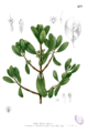
Plate depicting the "nilad" plant (Scyphiphora hydrophylacea), from Augustinian missionary Fray Francisco Manuel Blanco's botanical reference, "Flora de Filipinas"
-
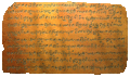
The Laguna Copperplate Inscription is the oldest historical record in the Philippines. It has the first historical reference to Tondo and dates back to Saka 822 (c. 900).
-
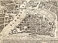
1734 map of the Walled City of Manila. The city was planned according to the Laws of the Indies.
-
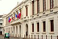
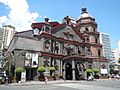
Ayuntamiento de Manila served as the City Hall during the Spanish Colonial Period.
-
Tutuban Main Station, which was built in 1887, is the main terminal of the Ferrocaril de Manila-Dagupan (now known as the Philippine National Railways). At the present moment, it serves as a shopping center and a public transit hub.
-
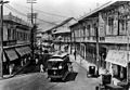
The tranvía running along Escolta Street during the American period.
-
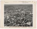
Aerial view of Manila, 1936
-
USS Essex TBF-1 Avenger dropping a bomb over Pasig River in Manila targeting the dockyard, November 14, 1944
-
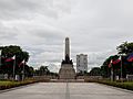
View of the Rizal Monument in Rizal Park.
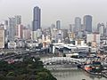
-
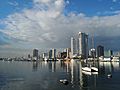
Skyline of Manila as seen from Harbour Square.
-
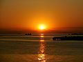
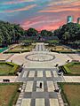
The Manila Bay sunset
-
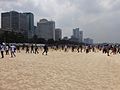
The Manila Bay Beach during the International Coastal Cleanup Day in September 2020
-
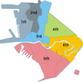
Manila is divided into six congressional districts.
-
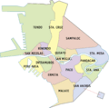
District map of Manila showing its sixteen districts.
-
Smog in Quiapo-Binondo area.
-
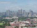
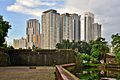
Ermita-Malate skyline in Manila
-
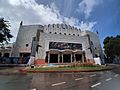
The façade of the NCCA Metropolitan Theater, designed by Filipino architect Juan M. Arellano
-
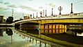
Jones Bridge was redeveloped in 2019 to "restore" it to its near-original design using Beaux-Arts architecture.
-
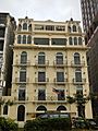
The Luneta Hotel, an example of French Renaissance architecture with Filipino stylized beaux art
-
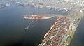
Aerial view of the Port of Manila, the chief port of the Philippines.
-
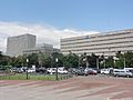
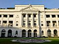
The Bangko Sentral ng Pilipinas, the central bank of the Philippines
-
Skyline of Binondo, the central business district of the city of Manila, as seen from Fort Santiago
-
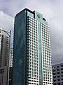
Landbank Plaza, the headquarters of the Land Bank of the Philippines.
-
The historic Plaza Moriones in Fort Santiago, Intramuros.
-

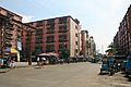
Divisoria is a popular flea market for locals and tourists.
-
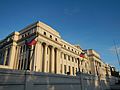
The National Museum of Fine Arts.
-
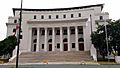
The National Museum of Natural History at Agrifina Circle, Rizal Park.
-
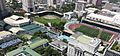
Aerial view of the city-owned Rizal Memorial Sports Complex, considered as the national sports complex of the Philippines.
-
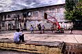
Children playing basketball at the ruins of San Ignacio Church in Intramuros
-
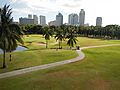
The Intramuros Golf Club
-
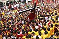
Catholic devotees during the Feast of the Black Nazarene (Traslacíon)
-
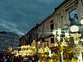
Grand Marian Procession in Intramuros
-
The Smokey Mountain Housing Project was built on a former landfill. Continuous development of housing buildings continues up to the present day.
-

Jeepneys are one of the most popular modes of transportation in Manila
-
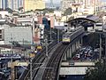
Pureza station of LRT Line 2 in Santa Mesa
-
De La Salle University is a Lasallian educational institution established in 1911.
-
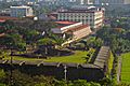
The campus of the University of the City of Manila and Baluarte de San Diego in Intramuros.
-
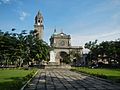
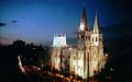
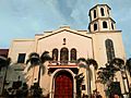
Manila Cathedral is the seat of Roman Catholic Archdiocese of Manila
-
The Minor Basilica of San Sebastián is the only all-steel church in Asia.
-
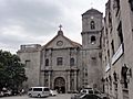
San Agustín Church in Intramuros, a UNESCO World Heritage Site.
-
Binondo Church serves the Roman Catholic Chinese community
-
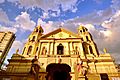
Quiapo Church, home of the iconic Black Nazarene whose Traslacion feast is celebrated every January 9
-
Sto. Niño de Pandacan Church before the 2020 fire


.jpg)

.jpg)


.JPG)
_wiki.jpg)


_(Manila)(2018-02-07).jpg)


_(2014).JPG)
.jpg)
.jpg)


_Facade_-_Front_View.jpg)


(2018-02-22).jpg)


_Manila,_Filipinas..jpg)
.JPG)


.jpg)
See also
 In Spanish: Manila para niños
