
Southwest Harbor, Maine facts for kids
Quick facts for kids
Southwest Harbor, Maine
|
||
|---|---|---|

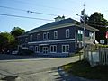
Southwest Harbor Town Offices
|
||
|
||

Southwest Harbor, Maine
Location in Maine

Southwest Harbor, Maine
Location in the United States
|
||
| Country | United States | |
| State | Maine | |
| County | Hancock | |
| Settled | 1761 | |
| Incorporated (town) | February 21, 1905 | |
| Villages | Southwest Harbor Manset Seawall |
|
| Area | ||
| • Total | 22.69 sq mi (58.77 km2) | |
| • Land | 13.51 sq mi (34.99 km2) | |
| • Water | 9.18 sq mi (23.78 km2) | |
| Elevation | 118 ft (36 m) | |
| Population
(2020)
|
||
| • Total | 1,756 | |
| • Density | 130/sq mi (50.2/km2) | |
| Time zone | UTC-5 (Eastern (EST)) | |
| • Summer (DST) | UTC-4 (EDT) | |
| ZIP codes |
04656, 04679
|
|
| Area code(s) | 207 Exchange: 244 | |
| FIPS code | 23-72865 | |
| GNIS feature ID | 0582740 | |

Southwest Harbor is a town in Hancock County, Maine, United States. Located on Mount Desert Island, the population was 1,756 at the 2020 census. The municipality contains within it the villages of Southwest Harbor, Manset, Seawall, Wonderland, and Pemetic Hills.
Contents
Geography
According to the United States Census Bureau, the town has a total area of 22.69 square miles (58.77 km2), of which 13.51 square miles (34.99 km2) is land and 9.18 square miles (23.78 km2) is water.
Demographics
| Historical population | |||
|---|---|---|---|
| Census | Pop. | %± | |
| 1910 | 888 | — | |
| 1920 | 824 | −7.2% | |
| 1930 | 888 | 7.8% | |
| 1940 | 1,260 | 41.9% | |
| 1950 | 1,534 | 21.7% | |
| 1960 | 1,480 | −3.5% | |
| 1970 | 1,657 | 12.0% | |
| 1980 | 1,855 | 11.9% | |
| 1990 | 1,952 | 5.2% | |
| 2000 | 1,966 | 0.7% | |
| 2010 | 1,764 | −10.3% | |
| 2020 | 1,756 | −0.5% | |
| U.S. Decennial Census | |||
2010 census
As of the census of 2010, there were 1,764 people, 835 households, and 483 families living in the town. The population density was 130.6 inhabitants per square mile (50.4/km2). There were 1,484 housing units at an average density of 109.8 per square mile (42.4/km2). The racial makeup of the town was 97.3% White, 0.2% African American, 0.5% Native American, 0.3% Asian, 0.3% from other races, and 1.4% from two or more races. Hispanic or Latino of any race were 1.0% of the population.
There were 835 households, of which 24.2% had children under the age of 18 living with them, 44.2% were married couples living together, 10.1% had a female householder with no husband present, 3.6% had a male householder with no wife present, and 42.2% were non-families. 35.0% of all households were made up of individuals, and 15.7% had someone living alone who was 65 years of age or older. The average household size was 2.10 and the average family size was 2.69.
The median age in the town was 47.2 years. 19.4% of residents were under the age of 18; 7.1% were between the ages of 18 and 24; 20% were from 25 to 44; 31.3% were from 45 to 64; and 22.1% were 65 years of age or older. The gender makeup of the town was 47.0% male and 53.0% female.
In popular culture
- Location filming for the 1999 television mini-series Storm of the Century took place in Southwest Harbor.
- The video for the song "Rebellion (Lies)" by Arcade Fire was filmed here.
- In the novel Fudge-a-Mania by Judy Blume, the main character and his family spend their summer vacation at a house in Southwest Harbor, sharing it with his archenemy.
Gallery
-
Southwest Harbor Police Department
-
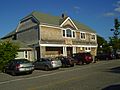
Southwest Harbor Public Library


Education
Southwest Harbor has one school, Pemetic Elementary School. The school educates students in kindergarten through eighth grade. The building originally housed Pemetic High School, which served Southwest Harbor and the neighboring town of Tremont. The elementary school includes two baseball fields and a soccer field. Today, high school students from Southwest Harbor and Tremont attend Mount Desert Island High School in the town of Mount Desert.
Notable people
- Myrna Fahey, actress
- Wendell Gilley, artist, bird carvings
Images for kids
-
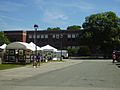
Pemetic Elementary School
-
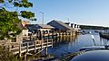
Beal's Lobster Pound


See also
 In Spanish: Southwest Harbor (Maine) para niños
