
Manvel, Texas facts for kids
Quick facts for kids
Manvel, Texas
|
|
|---|---|
| Nickname(s):
The Real Town & Country
|
|
| Motto(s):
City on the Rise
|
|

Location of Manvel, Texas
|
|
| Country | United States |
| State | Texas |
| County | Brazoria |
| Government | |
| • Type | Council-Manager |
| Area | |
| • Total | 27.50 sq mi (71.22 km2) |
| • Land | 27.45 sq mi (71.09 km2) |
| • Water | 0.05 sq mi (0.13 km2) |
| Elevation | 52 ft (16 m) |
| Population
(2010)
|
|
| • Total | 5,179 |
| • Estimate
(2019)
|
12,671 |
| • Density | 461.64/sq mi (178.24/km2) |
| Time zone | UTC-6 (Central (CST)) |
| • Summer (DST) | UTC-5 (CDT) |
| ZIP code |
77578
|
| Area code(s) | 281 |
| FIPS code | 48-46500 |
| GNIS feature ID | 1340905 |
Manvel is a city in Brazoria County, Texas, United States. As of the 2010 census the population was 5,179, up from 3,046 at the 2000 census.
Contents
Geography
Manvel is located in northern Brazoria County at 29°28′45″N 95°21′23″W / 29.47917°N 95.35639°W (29.479200, -95.356299). Iowa Colony is to the west, Pearland is to the north, and Alvin is to the east. Texas State Highway 6 passes through the community, leading 7 miles (11 km) east to Alvin, 37 miles (60 km) east to Galveston, and 20 miles (32 km) northwest to Sugar Land. Texas State Highway 288, a four-lane freeway, runs through the northwest part of Manvel, leading north 20 miles (32 km) to downtown Houston and south 23 miles (37 km) to Angleton, the Brazoria County seat.
According to the United States Census Bureau, the city has a total area of 23.6 square miles (61.0 km2), of which 23.5 square miles (60.9 km2) is land and 0.039 square miles (0.1 km2), or 0.12%, is water.
Demographics
| Historical population | |||
|---|---|---|---|
| Census | Pop. | %± | |
| 1970 | 106 | — | |
| 1980 | 3,549 | 3,248.1% | |
| 1990 | 3,733 | 5.2% | |
| 2000 | 3,046 | −18.4% | |
| 2010 | 5,179 | 70.0% | |
| 2019 (est.) | 12,671 | 144.7% | |
| U.S. Decennial Census | |||
As of the census of 2000, Manvel had a population of 3,046, 1,085 households, and 870 families in the city. The population density was 130.7 people per square mile (50.5/km2). There were 1,148 housing units at an average density of 49.3 per square mile (19.0/km2). The racial makeup of the city was 65.7% White, 13.9% African American, 0.6% Native American, 8.6% Asian, 8.9% from other races, and 2.3% from two or more races. Hispanic or Latino of any race were 15.6% of the population.
Of the 1,085 households, 36.4% had children under the age of 18 living with them, 67.9% were married couples living together, 7.6% had a female householder with no husband present, and 19.8% were non-families. 15.5% of households were one person and 4.4% were one person aged 65 or older. The average household size was 2.80 and the average family size was 3.13.
The age distribution was 25.8% under the age of 18, 7.1% from 18 to 24, 29.9% from 25 to 44, 28.7% from 45 to 64, and 8.5% 65 or older. The median age was 38 years. For every 100 females, there were 100.7 males. For every 100 females age 18 and over, there were 111.3 males.
The median household income was $65,862 and the median family income was $79,217. Males had a median income of $45,602 versus $28,083 for females. The per capita income for the city was $23,751. About 1.3% of families and 3.0% of the population were below the poverty line, including 2.6% of those under age 18 and 1.9% of those age 65 or over.
Education
Primary and secondary schools

Public schools
Students in Manvel attend schools in the Alvin Independent School District.
E.C. Mason Elementary School, Don Jeter Elementary School, Dr. James "Red" Duke Elementary School, Mary Marek Elementary School, Manvel Junior High School, Rodeo Palms Junior High School, Manvel High School and Shadow Creek High School serve the city of Manvel. Manvel was served by Alvin High School (in the nearby city of Alvin) until spring 2006. With the passage of a local bond, several new schools, including an additional high school located in the neighboring city of Iowa Colony, will be constructed in coming years.
Colleges and universities
Manvel is served by the Alvin Community College system, with limited evening and weekend courses being offered at Manvel High School during the Fall and Spring terms. Manvel is in the ACC taxation zone.
Manvel is also within 25 miles (40 km) to several larger colleges including the University of Houston, Rice University, Texas A&M Galveston, University of St. Thomas, Houston Community College, Texas Southern University, Baylor College of Medicine, University of Texas at Houston School of Medicine, University of Texas Medical Branch and Houston Baptist University.
Public libraries
The Manvel Library at 20514B Highway 6 is a part of the Brazoria County Library System.
Transportation and Infrastructure
Texas State Highway 6 passes through the community, leading 7 miles (11 km) east to Alvin, 37 miles (60 km) east to Galveston, and 20 miles (32 km) northwest to Sugar Land. Texas State Highway 288, a four-lane freeway, runs through the northwest part of Manvel, leading north 20 miles (32 km) to downtown Houston and south 23 miles (37 km) to Angleton, the Brazoria County seat.
Manvel has no mapped railways running through it or within it.
Air travel in Manvel is convenient to access. General aviation can be utilized at the nearby Houston Southwest Airport along state highway 6, and Houston Hobby International Airport is rather close to the city, with a driving distance of about 17 miles on the quickest route. The larger but farther George Bush Intercontinental Airport is also accessible by utilizing state highway 288 and Interstate 69, and driving distance on such route is around 43 miles from the center of Manvel.
Notable people
- D'Eriq King, University of Houston then Miami University quarterback
- Koda Martin, Arizona Cardinals offensive lineman
- Kyle Trask, Tampa Bay Buccaneers quarterback. Trask was picked with the 64th pick in the 2021 NFL Draft
- Brianna Turner, Phoenix Mercury forward
Images for kids
-
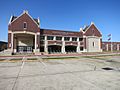
Manvel High School

See also
 In Spanish: Manvel (Texas) para niños
