Maricopa, California facts for kids
Quick facts for kids
City of Maricopa
|
|
|---|---|

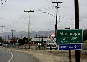
Northern city limit of Maricopa; the fire in the center is a gas flare from an active oil well
|
|

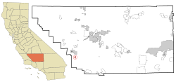
Location in Kern County and the state of California
|
|
| Country | |
| State | |
| County | Kern |
| Incorporated | July 25, 1911 |
| Area | |
| • Total | 1.50 sq mi (3.89 km2) |
| • Land | 1.50 sq mi (3.89 km2) |
| • Water | 0.00 sq mi (0.00 km2) 0% |
| Elevation | 883 ft (269 m) |
| Population
(2010)
|
|
| • Total | 1,154 |
| • Estimate
(2019)
|
1,192 |
| • Density | 793.61/sq mi (306.46/km2) |
| Time zone | UTC-8 (PST) |
| • Summer (DST) | UTC-7 (PDT) |
| ZIP code |
93252
|
| Area code | 661 |
| FIPS code | 06-45736 |
| GNIS feature IDs | 1652749, 2411033 |
Maricopa is a city in Kern County, California. Maricopa is located 6.5 miles (10 km) south-southeast of Taft, at an elevation of 883 feet (269 m). The population was 1,154 at the 2010 census, up from 1,111 at the 2000 census. The Carrizo Plain is located to the northwest, and the enormous Midway-Sunset Oil Field, the third largest oil field in the United States, is adjacent on the north and east.
Contents
Geography
According to the United States Census Bureau, the city has a total area of 1.5 square miles (3.9 km2), all of it land. Maricopa is in the extreme southwestern corner of the San Joaquin Valley, on the first rise of land into the foothills of the Coast Ranges, with the Temblor Range, following the San Andreas Fault, trending northwest of town, and the San Emigdio Mountains to the southeast. The climate of the area is hot and semi-arid, with summertime temperatures routinely exceeding 100 degrees Fahrenheit. Freezes occur in the winter, with the mean period without freezes being about 275 days. About six inches of rain falls annually in Maricopa.
History
The first post office opened in 1901. Maricopa incorporated in 1911. The city was named after the Maricopa Indians.
Demographics
| Historical population | |||
|---|---|---|---|
| Census | Pop. | %± | |
| 1920 | 1,121 | — | |
| 1930 | 1,071 | −4.5% | |
| 1940 | 670 | −37.4% | |
| 1950 | 800 | 19.4% | |
| 1960 | 648 | −19.0% | |
| 1970 | 740 | 14.2% | |
| 1980 | 946 | 27.8% | |
| 1990 | 1,193 | 26.1% | |
| 2000 | 1,111 | −6.9% | |
| 2010 | 1,154 | 3.9% | |
| 2019 (est.) | 1,192 | 3.3% | |
| U.S. Decennial Census | |||
2010
At the 2010 census Maricopa had a population of 1,154. The population density was 768.4 people per square mile (296.7/km2). The racial makeup of Maricopa was 958 (83.0%) White, 1 (0.1%) African American, 27 (2.3%) Native American, 16 (1.4%) Asian, 2 (0.2%) Pacific Islander, 112 (9.7%) from other races, and 38 (3.3%) from two or more races. Hispanic or Latino of any race were 232 people (20.1%).
The whole population lived in households, no one lived in non-institutionalized group quarters and no one was institutionalized.
There were 414 households, 157 (37.9%) had children under the age of 18 living in them, 191 (46.1%) were opposite-sex married couples living together, 66 (15.9%) had a female householder with no husband present, 34 (8.2%) had a male householder with no wife present. There were 50 (12.1%) unmarried opposite-sex partnerships, and 2 (0.5%) same-sex married couples or partnerships. 91 households (22.0%) were one person and 33 (8.0%) had someone living alone who was 65 or older. The average household size was 2.79. There were 291 families (70.3% of households); the average family size was 3.20.
The age distribution was 306 people (26.5%) under the age of 18, 112 people (9.7%) aged 18 to 24, 252 people (21.8%) aged 25 to 44, 349 people (30.2%) aged 45 to 64, and 135 people (11.7%) who were 65 or older. The median age was 39.4 years. For every 100 females, there were 101.7 males. For every 100 females age 18 and over, there were 103.4 males.
There were 466 housing units at an average density of 310.3 per square mile, of the occupied units 268 (64.7%) were owner-occupied and 146 (35.3%) were rented. The homeowner vacancy rate was 1.8%; the rental vacancy rate was 9.8%. 704 people (61.0% of the population) lived in owner-occupied housing units and 450 people (39.0%) lived in rental housing units.
2000
At the 2000 census there were 1,111 people in 404 households, including 302 families, in the city. The population density was 739.7 people per square mile (286.0/km2). There were 460 housing units at an average density of 306.3 per square mile (118.4/km2). The racial makeup of the city was 85.87% White, 1.98% Native American, 0.45% Asian, 8.91% from other races, and 2.79% from two or more races. 13.50% of the population were Hispanic or Latino of any race. Of the 404 households 34.2% had children under the age of 18 living with them, 59.2% were married couples living together, 11.1% had a female householder with no husband present, and 25.2% were non-families. 23.5% of households were one person and 9.2% were one person aged 65 or older. The average household size was 2.75 and the average family size was 3.22.
The age distribution was 29.8% under the age of 18, 7.0% from 18 to 24, 25.8% from 25 to 44, 26.1% from 45 to 64, and 11.3% 65 or older. The median age was 36 years. For every 100 females, there were 111.6 males. For every 100 females age 18 and over, there were 105.3 males.
The median income for a household in the city was $27,917, and the median family income was $31,761. Males had a median income of $31,161 versus $23,333 for females. The per capita income for the city was $15,692. About 15.6% of families and 21.3% of the population were below the poverty line, including 27.2% of those under age 18 and 4.5% of those age 65 or over.
Transportation
Maricopa lies at the junction of Route 166 and Route 33.
The City of Taft operates Taft-Maricopa Area Transit, with buses serving Taft and Maricopa.
See also
 In Spanish: Maricopa (California) para niños


